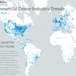
Today DroneDeploy released their second Report on Commercial Drone Industry Trends. The new report is based on 5 million acres mapped, up from the 2 million acres the initial report was based on (that report was released last March). DroneDeploy is seeing significant increase in acres mapped on its platform and it is growing quickly. Whether a report based on data from a single … [Read more...] about DroneDeploy Releases Report on Industry Trends
DroneDeploy
DroneDeploy App Features Contour Export; Enables Operator to Beat Competition
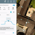
Sponsored by DroneDeploy — Easily leverage drone data in Autodesk AutoCAD, ArcGIS, and other software Elevation data is crucial to many industries. Businesses are beginning to look to drones as a faster, safer, more cost-effective alternative to traditional ground-based survey methods of capturing elevation data. Over the last few months, we’ve rolled out a number of tools … [Read more...] about DroneDeploy App Features Contour Export; Enables Operator to Beat Competition
Is Esri’s Drone2Map a Game Changer?
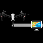
Features should appeal to Esri users, but will they appeal to non-Esri users? QuickTake THE FACTS: In February 2016, Esri released an application called Drone2Map for ArcGIS. Drone2Map (D2M) takes raw image data from drones and creates digital surface models, orthomosaics, 3D-point clouds and 3D PDFs that can be shared. Data processed by Drone2Map can also be rendered in … [Read more...] about Is Esri’s Drone2Map a Game Changer?
DJI and DroneDeploy Partner on Thermal Mapping
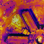
Drone manufacturer DJI and leading commercial drone cloud software platform DroneDeploy announced a new thermal mapping solution yesterday at the Intersolar North America conference. The announcement was well-placed: a drone thermal mapping solution could dramatically increase the efficiency - and lower the cost - of the solar panel installation and inspection. In fact, the … [Read more...] about DJI and DroneDeploy Partner on Thermal Mapping
7 Common Questions About Drones in Agriculture
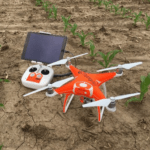
Sponsored by DroneDeploy How high to fly, how to detect crop stress and more As we head into July, growers across the Northern Hemisphere are busy monitoring the growth of their crops, applying nutrients, fertilizers and pesticides, and beginning to estimate their yields for the season. More and more of them are using drones to help them gather information — and when we talk … [Read more...] about 7 Common Questions About Drones in Agriculture


