• Skip to main content
  • Skip to secondary menu
  • Skip to primary sidebar
  • Skip to secondary sidebar
  • Skip to footer
  • DroneRacingLife
  • DroneFlyers
  • Newsletter
DroneLife

DRONELIFE

Stay up to date on all the latest Drone News

  • News
  • Products
  • Industries
    • Agriculture
    • Construction
    • Delivery
    • Dual Use
    • Inspection
    • Public Safety
    • Surveying
  • Enthusiasts
  • Regulations
  • Business
  • Video
  • Podcasts

Is Esri’s Drone2Map a Game Changer?

July 23, 2016 by Alan Phillips 5 Comments

Features should appeal to Esri users, but will they appeal to non-Esri users?

QuickTake

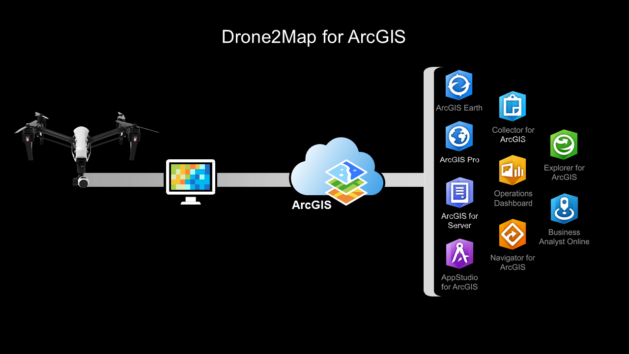
THE FACTS: In February 2016, Esri released an application called Drone2Map for ArcGIS. Drone2Map (D2M) takes raw image data from drones and creates digital surface models, orthomosaics, 3D-point clouds and 3D PDFs that can be shared. Data processed by Drone2Map can also be rendered in Esri’s ArcGIS online web service and integrated into ArcGIS for further processing. The photogrammetry engine in Drone2Map is Pix4D. Esri licenses D2M as a yearly subscription for $3,500 plus a nominal data storage cost.

Click on the image for a larger view. Use back button ot return to article.

esri-imagery-and-beyond-160217123229 slide 18

Esri’s ArcGIS platform provides maps and a wide variety of analytical tools to governments, business, and utilities. Applications range from finding the optimal retail store location, to mapping pipelines, to planning public works projects. In the past, Esri has been rather lethargic in adopting new technology, but to their credit, they have been a forerunner in recognizing the potential of drone-generated data. This new product is proof of that.

WHAT’S COOL AND WHAT’S NOT: If you don’t know Esri, then you don’t know geographic information systems (GIS). ESRI so dominates the GIS industry that the name GIS and Esri are almost synonymous. Esri has been doing business since 1969, has 9,000 employees in 67 countries, 41 offices worldwide, and has annual sales north of $900 million dollars.

More than 350,000 organizations use Esri products, but the number of users is actually much larger because many of these companies have licensed multiple copies of their software. In other words, Esri’s user base is large enough be a market in itself. The D2M feature set, combined with ArcGIS integration, should be appealing to current Esri users.

On the downside, Drone2Map only becomes an end-to-end solution when it is used with the ArcGIS platform, making it an additional cost consideration for non-Esri users. Also, sales of D2M, like other drone data solutions, will be paced by the speed at which drone technology is adopted by enterprises and the data is integrated into the GIS workflow.

THE COMPETITION: Harris Geospatial Solutions and Icaros, Inc. have formed a partnership that enables Harris to sell Icaros’s One Button imaging processing software. Like Drone2Map, OneButton generates 2D, 3D, and orthorectified images from drone data. OneButton may not attract Esri customers, but it will be a compelling alternative for those who don’t use Esri tools.

There is an irony in Esri’s offering—Pix4D is both a supplier to and a competitor with Esri. Irony aside, we see this as a win/win situation for Pix4D because, being part of Drone2Map, they profit from each Drone2Map sale and from sales to non-Esri customers.

There is another twist in the story here. Esri announced last month a beta integration of its ArcGIS software with the very popular DroneDeploy software. But right now, DroneDeploy offers much more to surveyors and mappers than Drone2Map because it offers a simple mobile app for mission planning, data-to-cloud upload, and the same sharable data analysis (digital surface models, orthomosaics, 3D-point clouds, 3D PDFs, etc.) that Drone2Map does. It seems to us a push-button integration to ArcGIS just makes DroneDeploy more valuable.

BOTTOM LINE: Drone2Map for ArcGIS is important to Esri because it works on several different levels. For one, the strong feature set and ArcGIS integration should attract current users. If one half of one percent of Esri’s 350,000 users purchase Drone2Map, Esri will realize a revenue gain of over $6 million.

In addition to generating revenue from their user community, Drone2Map also works as an Esri promotional tool. Drone companies like 3D Robotics, senseFly, and Drone Deploy all want to promote their solutions as working with Esri products. This is free publicity and introduces prospects outside of Esri’s user base to the company.

Drone2Map should sell well to the Esri user base but considering the fact that it is not a complete mobile end-to-end solution, Esri will be challenged to successfully find new customers outside their user base. Also, the commercial drone industry is fast moving and very fluid. Esri may have a difficult time keeping up. However, you can never count Esri out. Once the market settles, Esri will be a formidable competitor.

20140718_ColinSnow_0024_1x1_WebColin Snow is CEO and Founder of Skylogic Research, LLC (aka Drone Analyst®), a research, content, and advisory services firm for the commercial drone industry. Colin is a 25-year technology industry veteran with a background in market research, enterprise software, electronics, digital imaging, and mobility.

Alan Phillips
Alan Phillips

Alan is serial entrepreneur, active angel investor, and a drone enthusiast. He co-founded DRONELIFE.com to address the emerging commercial market for drones and drone technology. Prior to DRONELIFE.com, Alan co-founded Where.com, ThinkingScreen Media, and Nurse.com. Recently, Alan has co-founded Crowditz.com,  a leader in Equity Crowdfunding Data, Analytics, and Insights.  Alan can be reached at alan(at)dronelife.com

Filed Under: Applications, Colin Snow, News Tagged With: Colin Snow, DroneDeploy, Esri, Pix4D

Reader Interactions

Comments

  1. Steve Hall says

    February 5, 2017 at 12:39 am

    Why bother with Drone2Map when it uses the engine from Pix4D but with reduced options? It’s slightly cheaper and has the ESRI brand but Pix4D is a more versatile product and offers a mission authoring app as well. I just tested the two products as demo’s side by side and there was no appreciable difference between the two at default settings.

    Reply
  2. Yuni says

    August 21, 2016 at 3:49 pm

    Is this good? or too much high cost? compare to what pokemon go doo

    Reply
    • Marcin says

      September 2, 2016 at 5:13 am

      Colin could you make comparison with Erdas Imagine UAV software?
      Seems drone2map its just another simplified point cloud matching workflow.

      Reply

Trackbacks

  1. Esri Technology Gets Faster, Easier, and More Robust – Brilliant Geographers says:
    July 10, 2020 at 2:02 pm

    […] Sources: Drone2Map for ArcGIS […]

    Reply
  2. Is Esri’s Drone2Map a Game Changer? | Drone, UAV, Quadcopter a Multi Rotor News says:
    July 23, 2016 at 12:16 pm

    […] post Is Esri’s Drone2Map a Game Changer? appeared first on […]

    Reply

Leave a Reply Cancel reply

Your email address will not be published. Required fields are marked *

Primary Sidebar

LATEST

Skydio Raises $110M Series F, Signals Strong Revenue and U.S. Manufacturing Push

CEO Adam Bry highlights reduced capital needs as company expands production and commits billions to domestic manufacturing Skydio has raised…

Continue Reading Skydio Raises $110M Series F, Signals Strong Revenue and U.S. Manufacturing Push

Teledyne FLIR Defense Expands Payload Program with Emesent Hovermap for GPS-Denied Operations

New integration brings LiDAR mapping and radiation detection together across air and ground platforms Teledyne FLIR Defense has expanded its…

Continue Reading Teledyne FLIR Defense Expands Payload Program with Emesent Hovermap for GPS-Denied Operations

ideaForge Signs MoU with Japan’s DMP to Develop AI Drones

India’s largest UAV maker partners with Tokyo-based Digital Media Professionals to integrate edge AI silicon and enter the Japanese defense…

Continue Reading ideaForge Signs MoU with Japan’s DMP to Develop AI Drones

WISPR Systems’ SkyScout 2+ Earns Blue UAS Cleared List Approval

WISPR Systems’ SkyScout 2+ receives Blue UAS Cleared List designation from DCMA, validating the platform for federal, public safety, and…

Continue Reading WISPR Systems’ SkyScout 2+ Earns Blue UAS Cleared List Approval

SkyfireAI Raises $11M to Advance Autonomous Multi-Drone Operations for Public Safety

New platform aims to reduce operator workload while enabling coordinated drone response at scale SkyfireAI has announced an $11 million…

Continue Reading SkyfireAI Raises $11M to Advance Autonomous Multi-Drone Operations for Public Safety

What Starlink Actually Changes for Police Drones: A Look at BRINC’s Guardian

BRINC Guardian with Starlink: A New Standard for Drone as First Responder?Satellite connectivity, redundancy, and real-world range could reshape police…

Continue Reading What Starlink Actually Changes for Police Drones: A Look at BRINC’s Guardian

Spokane PD Adds Skydio Drones Ahead of FIFA World Cup Security Push

Spokane PD to get 4 Skydio drones for World Cup security By DRONELIFE Features Editor Jim Magill The Spokane, Washington…

Continue Reading Spokane PD Adds Skydio Drones Ahead of FIFA World Cup Security Push

Theft of Agricultural Spray Drones in New Jersey Raises Security Questions-UPDATE

Update, Tuesday April 28, 2026: New Jersey state police have reported that the stolen drones were recovered yesterday from a…

Continue Reading Theft of Agricultural Spray Drones in New Jersey Raises Security Questions-UPDATE

Volocopter Unveils VoloXPro and Expands into Pilot Training Market, Air Sports

New ultralight multicopter targets private pilots, training organizations, and future air taxi operators Volocopter has introduced the VoloXPro, a new…

Continue Reading Volocopter Unveils VoloXPro and Expands into Pilot Training Market, Air Sports

Matternet Launches NHS Drone Deliveries in Central London

New service connects major hospital campuses to move critical medical items in minutes Matternet has launched drone delivery operations for…

Continue Reading Matternet Launches NHS Drone Deliveries in Central London

Secondary Sidebar

Footer

SPONSORED

Inspired Flight Gremsy IF800 VIO F1 drones geo week

What Will It Take to Strengthen U.S. Drone Manufacturing? A Conversation with Inspired Flight’s CEO

Global Mapper Mobile data collection

Collection Ground Control Points with Global Mapper Mobile

Military Drone Mapping Solutions

How SimActive’s Correlator3D™ is Revolutionizing Military Mapping: An Exclusive Interview with CEO Philippe Simard

Photogrammetry Accuracy Standards

SimActive Photogrammetry Software: Enabling Users to Meet Accuracy Standards for Over 20 Years

NACT Engineering Parrot ANAFI tether indoor shot

Smart Tether for Parrot ANAFI USA from NACT Engineering

Blue Marble, features global mapper, features Blue Marble

Check Out These New Features in Global Mapper v25 from Blue Marble

About Us | Contact Us | Advertise With Us | Write for Us | Privacy Policy | Terms of Service

The Trusted Source for the Business of Drones.

This website uses cookies and third party services. By clicking OK, you are agreeing to our privacy policy. ACCEPT

Manage consent

Privacy Overview

This website uses cookies to improve your experience while you navigate through the website. Out of these, the cookies that are categorized as necessary are stored on your browser as they are essential for the working of basic functionalities of the website. We also use third-party cookies that help us analyze and understand how you use this website. These cookies will be stored in your browser only with your consent. You also have the option to opt-out of these cookies. But opting out of some of these cookies may affect your browsing experience.
Necessary
Always Enabled
Necessary cookies are absolutely essential for the website to function properly. These cookies ensure basic functionalities and security features of the website, anonymously.
CookieDurationDescription
cookielawinfo-checkbox-analytics11 monthsThis cookie is set by GDPR Cookie Consent plugin. The cookie is used to store the user consent for the cookies in the category "Analytics".
cookielawinfo-checkbox-functional11 monthsThe cookie is set by GDPR cookie consent to record the user consent for the cookies in the category "Functional".
cookielawinfo-checkbox-necessary11 monthsThis cookie is set by GDPR Cookie Consent plugin. The cookies is used to store the user consent for the cookies in the category "Necessary".
cookielawinfo-checkbox-others11 monthsThis cookie is set by GDPR Cookie Consent plugin. The cookie is used to store the user consent for the cookies in the category "Other.
cookielawinfo-checkbox-performance11 monthsThis cookie is set by GDPR Cookie Consent plugin. The cookie is used to store the user consent for the cookies in the category "Performance".
viewed_cookie_policy11 monthsThe cookie is set by the GDPR Cookie Consent plugin and is used to store whether or not user has consented to the use of cookies. It does not store any personal data.
Functional
Functional cookies help to perform certain functionalities like sharing the content of the website on social media platforms, collect feedbacks, and other third-party features.
Performance
Performance cookies are used to understand and analyze the key performance indexes of the website which helps in delivering a better user experience for the visitors.
Analytics
Analytical cookies are used to understand how visitors interact with the website. These cookies help provide information on metrics the number of visitors, bounce rate, traffic source, etc.
Advertisement
Advertisement cookies are used to provide visitors with relevant ads and marketing campaigns. These cookies track visitors across websites and collect information to provide customized ads.
Others
Other uncategorized cookies are those that are being analyzed and have not been classified into a category as yet.
SAVE & ACCEPT