Sponsored by DroneDeploy
How high to fly, how to detect crop stress and more
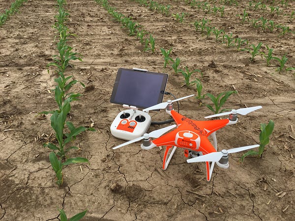
As we head into July, growers across the Northern Hemisphere are busy monitoring the growth of their crops, applying nutrients, fertilizers and pesticides, and beginning to estimate their yields for the season. More and more of them are using drones to help them gather information — and when we talk to these growers, there are a certain questions we hear a lot.
We put together this post to consolidate useful tips and information in one place and address these frequently asked questions:
- How high should I fly and what overlap should I use?
- How can I map larger areas and fly offline with DroneDeploy?
- How do I view plant health data? Do I need a special camera?
- What’s new that I should know about?
- How can I export my data to compare it to yield maps, soil maps and other data?
- Where can I go to learn more or get help?
- What plan should I buy?
1. How high should I fly and what overlap should I use?
There isn’t a formula that will tell you exactly how high to fly and how much overlap to use. That said, having an understanding of how flight altitude and overlap contribute to your map quality can help you choose better settings, and there are a few general guidelines that you can use.
First, let’s talk about flight altitude. At the most basic level, flying higher allows you to cover more ground in a shorter amount of time with less battery usage. Since many fields are quite large, many drone operators in ag fly as high as they can. In the U.S., that means just under 400 ft, the maximum height permitted by the FAA.
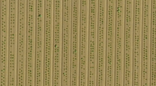
The downside to flying high is that the imagery captured is lower resolution than if you flew lower. That’s why how high you should fly depends on how you want to use the map. If you are crop-scouting a relatively mature crop and simply looking for areas of variability, you probably don’t need very high resolution imagery. However, if you’re looking at emergence of young plants, you may need to fly lower (150–200 feet) to be able to make out the plants against the soil in your completed map.
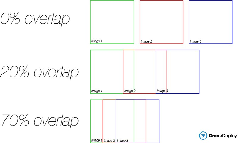
Overlap refers to the amount of overlap between the photos that the drone captures. When DroneDeploy processes a map, our software looks for features that appear across multiple photos, and uses the recognition of those features to stitch the images together into a map. In general, the higher the overlap, the easier it is for the software to identify features across multiple photos, and the higher the likelihood that it will generate a successful, high quality map.
As you might have guessed, there’s a trade-off. The higher the overlap, the closer together the legs of the drone’s flight paths will be, the longer the flight will take, the more battery the drone will consume, and the more images the drone will capture to cover the same area.
To learn more about map stitching and tips for successful maps, check out these resources:
- Making Successful Maps (in our Help center)
- Best Practices for Stitching Crop Imagery — from AgFlyers
2. How can I map larger areas and fly offline with DroneDeploy?
It’s not uncommon for DroneDeploy users in agriculture to want to map large fields, many of which are in areas with poor wifi and cell service. Fortunately, you can mitigate both of these potential issues by planning ahead.
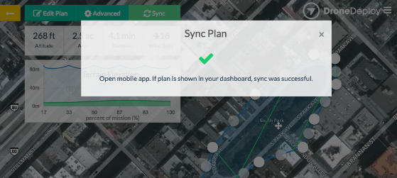
Plan your flights on your computer. If you’re concerned about connectivity issues, it’s a great idea to make your flight plans ahead of time, when you’re back at your computer. Then, while you still have connectivity, open the DroneDeploy app on your mobile device to sync the plans. After the plans sync, you can go out to the field and fly — no cell or wifi connection required.
Bring extra batteries. If you’re mapping large areas (over 100 acres), the batteries are the limiting factor in how much ground you can cover. Fortunately, when your battery runs low, it’s very easy to bring the drone back, swap in a new battery, and keep mapping. If you’re in the middle of a mission and you see the battery get low, just click the “Home” button to bring the drone home. Then swap in the new battery and re-open the plan you were flying. The plan should automatically know where to restart the mission, but even if it doesn’t, you can manually select the restart point.
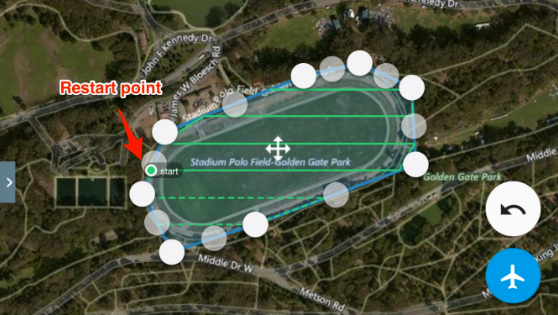
Pro tip: To maximize battery efficiency when mapping large areas, click the “Home” button when the drone is closest to you in its path — that will minimize the amount of time and battery life spent flying back and forth for the swap.
Interested in learning more about how to charge and maintain your batteries? Check out some of these resources:
- 15 Things Every LiPo Battery User Should Know — from The Drone Girl
- A Guide to Understanding LiPo Batteries — from Roger’s Hobby Center
3. How do I view plant health data? Do I need a special camera?
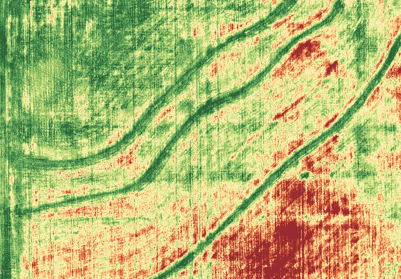
If you’re reading this post, odds are you’ve seen one of these red and green maps and heard the term NDVI — but you still might have a lot of questions about how to use it.
Let’s start with the basics. Healthy plants reflect a lot of near infrared (NIR) and green light and absorb a lot of red light. Vegetation indices interpret the amount of light captured across different wavelengths in order to increase the contrast in your map and highlight variability in a way that corresponds to plant health or stress. Different vegetation indices were developed with different purposes and for different camera or sensor types. NDVI (Normalized Difference Vegetation Index, Rouse et al., 1973) is one of the oldest and most well-known indices, and it’s intended to be used with NIR imagery.
What this means is that if you want to use the NDVI index for true NDVI, you need a NIR camera. However, if you don’t have a NIR camera, you can still use a vegetation index to highlight variability. In fact, one of the indices you’ll find in DroneDeploy, the VARI index (Visible Atmospherically Resistant Index, Gitelson et al., 2002), is intended explicitly for use with visible spectrum (Red Green Blue or RGB) imagery.
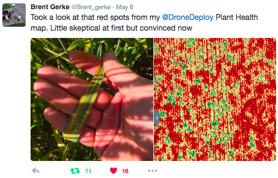
One of our recent case studies shows how a first time mapper used the RGB camera on his Phantom 4 with the VARI index to assess wind damage and detect rust fungus.
It’s important to note that not all NIR cameras are the same. When applying the NDVI index in DroneDeploy, you will need to select the type of filter you used to capture the imagery in the “Band Order” dropdown. Not sure what filter to select on your map? Check out our guide that lists the filter types for many common cameras.
Want to learn more? Check out these resources:
- What can NDVI drones do for my business? Part 1 and Part 2 (Blog posts where experts share their perspectives)
- Plant Health and Understanding NDVI (Help Center documentation)
4. What’s new that I should know about?
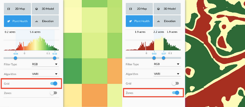
Zone Management
Your Plant Health map will show a high degree of detail, but sometimes it’s helpful to aggregate the data in your map into similar regions by applying zones or a grid. Not only can this help you visually detect health differences between larger areas, it also makes the dataset more manageable to use outside of DroneDeploy, either for analyzing in other software or for inputting to precision ag equipment. Learn more about management zones.
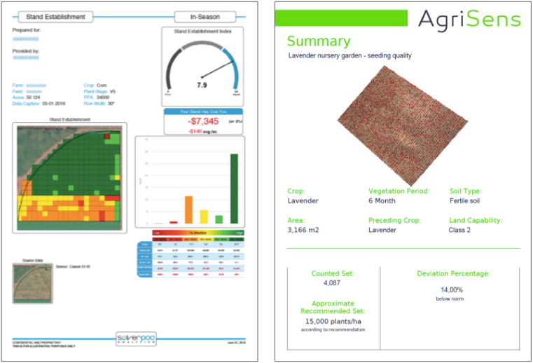
Plant Count and Stand Count Tools
Estimating plant counts using conventional methods is a time-consuming, manual process, and since only sample areas are counted, it doesn’t give you a complete view of your plant or stand count. Now DroneDeploy customers can use two new third-party tools available from within the DroneDeploy dashboard to automate the process and provide more complete, accurate data. The tool from Aglytix is intended for analyzing stand count in emergent corn and soy, whereas the tool from AgriSens specializes in counting visibly distinct plant like trees in an orchard or tomato plantings in a field. Learn more about these new plant count tools.
Curious about how growers are using these tools? Check out this recent case study about how one grower used the plant count tool to count over 400,000 tomato plants and show that losses after transplanting by a third party were higher than reported so that the planter could be held accountable.
5. How can I export my map to compare it to yield maps, soil maps and other data?
A drone map can help you tell that an area of your crop is stressed, but to understand why it’s stressed or what that means for your yield, you need more information. Ground-truthing is one important way to get it, but you can also combine your drone map with other data sets, like your soil sample data or last year’s yield map to get deeper insights.
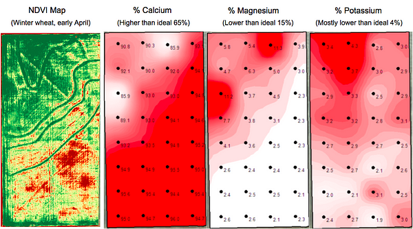
For example, in a recent case study, a team of experts explored the relationship between soil sample data and a drone health map and found surprising correlations.
To export a map, first go to the layer of the map that you want to export (orthomosaic, plant health, elevation, etc.) and then click the “Export” button. From there, you can customize the export depending on your needs. Possible options include exporting raster (GeoTiff) or vector (shapefile) data, projecting in a local EPSG coordinate system, and choosing a level of resolution. If you plan to use the imagery in specific precision ag software, we also provide guidelines to help make sure you export in the right format.
Want to learn more? Check out these resources:
- Exporting Your Data — a step-by-step guide on our Help Center
- Vector or Raster, Spatial Data is Important to Your Farm — a great introduction to spatial data types from Agflyers
6. Where can I go to learn more or get help?
During the growing season, customers on our special ag plan (see below for more information) can take advantage of a 2 hour training session with experts on using drones in agriculture from AgFlyers and reach out to our support team by email or live chat from 8 am to 7 pm CDT to get help with specific issues and questions.
Looking explore on your own? Here are some additional resources to get you started:
- Help Center. Check out our detailed step-by-step guides on how to use DroneDeploy, including this guide for agriculture.
- Forum. Visit our active forum to stay up to date on recent developments and get advice from our community.
- YouTube Channel. Check out the DroneDeploy channel to see our latest how-to videos.
7. What plan should I buy?
Before you buy a plan, try DroneDeploy for yourself! Sign up today to start your free 30-day trial of the Pro plan today. If you need to map larger areas or export data for use in farm software, the DroneDeploy Business Plan might better fit your needs. Check out our pricing page to learn more about our different options. Not sure which plan is best for you? Just reach out to us at sales@dronedeploy.com and one of our representatives would be happy to help you find the right plan.
Frank Schroth is editor in chief of DroneLife, the authoritative source for news and analysis on the drone industry: it’s people, products, trends, and events.
Email Frank
TWITTER:@fschroth


DRONE-CATCHING HEXACOPTER FIRES A LARGE NET TO REEL IN SUSPICIOUS AIRCRAFT
http://yuneec.droneinner.com/drone-catching-hexacopter-fires-a-large-net-to-reel-in-suspicious-aircraft