
SimActive Inc., recently announces the expansion of its network of resellers for medium format licenses. The new strategic alliances allow them to address the growing market need for processing imagery from medium format sensors. Partners include firms such as LiDARUSA, who offers SimActive’s Correlator3D™ to complement Phase One cameras. This announcement follows a recent … [Read more...] about SimActive Expands its Partner Network for Medium Format Camera Solutions
drone surveying
Mapping from a Drone vs. Mapping from Manned Aircraft or Satellite Data: The Difference is Getting Smaller All the Time with SimActive
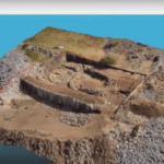
Creating 3D models and maps from aerial footage isn't a new idea. Sophisticated, survey grade models from satellite and aircraft images have been used for large scale environmental surveys, construction projects, and other applications. That functionality is incredibly valuable - and until recently, reserved for government and large industry due to the expense. Drones, … [Read more...] about Mapping from a Drone vs. Mapping from Manned Aircraft or Satellite Data: The Difference is Getting Smaller All the Time with SimActive
Endurance Flight without a Helicopter: Drone Tech Firm Harris Aerial Demonstrates LiDAR with Carrier H4 Hybrid
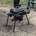
Aerial LiDAR surveys aren't new technology - but now U.S. - based Harris Aerial has demonstrated a new and ground-breaking way of performing them. LiDAR surveys provide critically accurate survey data, allowing for the creation of precise 3D models. LiDAR attached to a helicopter or other manned aircraft have been used for over 50 years in applications like natural hazard … [Read more...] about Endurance Flight without a Helicopter: Drone Tech Firm Harris Aerial Demonstrates LiDAR with Carrier H4 Hybrid
DJI and Datumate Partner to Deliver Site Survey Solution
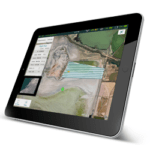
Firms partner to provide software, app ease & automate surveying, infrastructure-mapping and inspection The Chinese drone powerhouse DJI and Datumate, a developer of geomatics software, are offering a drone, software and app package that automates and expedites site surveys. The DJI-Datumate Site Survey Solution is targeted at professionals that want to simplify … [Read more...] about DJI and Datumate Partner to Deliver Site Survey Solution
FLIR Vue Expands Benefits of Thermal Imaging to UAS
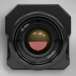
Sponsored by FLIR Systems — FLIR Systems has been a leading provider of thermal imaging technology to military and sureillance markets for years. But recently they have taken bold and significant steps to avail consumer and commercial markets to the benefits of thermal imaging. This includes the UAS market which can benefit mightily from this functionality in a number of … [Read more...] about FLIR Vue Expands Benefits of Thermal Imaging to UAS


