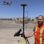
Real-Time Kinematic (RTK) is a buzz term in the UA industry, one many pilots may not understand, even though they may be “mapping” with an uncrewed aircraft (drone). When it comes to RTK and drone mapping, how necessary is the technology to a drone services provider? Will it earn a services provider more money? The following is a guest post by drone industry veteran … [Read more...] about RTK and Drone Mapping: Do You Need It? Is It Worth It?
drone surveying
Surveyors Wanted to Shut this Drone Photographer Down. Now, He’s Fighting Back. [VIDEO]
Is drone mapping surveying without a license? A First Amendment lawsuit in North Carolina says surveyors cannot stop drone operators from selling photos and making maps. Hiring a surveyor is an expensive buisness, but necessary if you want to establish legal property lines. What if you just want to see what your property looks like, or create a visual map of your property … [Read more...] about Surveyors Wanted to Shut this Drone Photographer Down. Now, He’s Fighting Back. [VIDEO]
COVID Response: Drone Service Providers to the Rescue
As industries across the globe come to grips with the “new normal” of a COVID-19 challenges, drone service providers (DSP) are launching new levels of innovation across a range of public and commercial sectors. Last year, Barclays projected drones will lower costs by $100 billion across a majority of industries. The FAA paints a rosy picture of clear skies for drone growth, … [Read more...] about COVID Response: Drone Service Providers to the Rescue
Photogrammetry is Evolving: Pix4D Announces Pix4Dmatic

As mapping professionals are called on to map larger and larger areas around the world, photogrammetry software is evolving to meet their needs. Today, Pix4D announces PixDmatic: faster, accurate photogrammetry on a larger scale. "Projects that would have previously been mapped by aircraft are now being surveyed with drones," says a Pix4D press release. "With Pix4Dmatic, … [Read more...] about Photogrammetry is Evolving: Pix4D Announces Pix4Dmatic
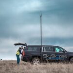
Drone Marketing Meets Reality TV With Surveying as the Backdrop

We here at DRONELIFE are as vulnerable as anyone else to the joys of reality TV, so we were pleased to see that drone provider Microdrones is scheduled to release a reality TV styled video webinar series named Down to Earth. The idea is to show the challenges and hazards that surveying crews face in the field. The series will premiere next Wednesday, February 19. … [Read more...] about Drone Marketing Meets Reality TV With Surveying as the Backdrop


