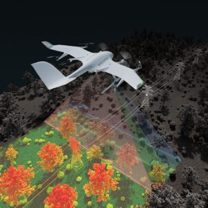
New Application Enables Efficient Infrastructure and Terrain Mapping Wingcopter has announced an expansion of its offerings to include long-range beyond visual line of sight (BVLOS) LiDAR surveying solutions. The Wingcopter 198, the company’s flagship drone, will be equipped with advanced laser scanning and camera systems to enable rapid, high-quality data … [Read more...] about Wingcopter Expands into Long-Range LiDAR Surveying
drone mapping
GeoCue and Clogworks Technologies Announce Partnership to Expand LiDAR Drone Mapping Solutions
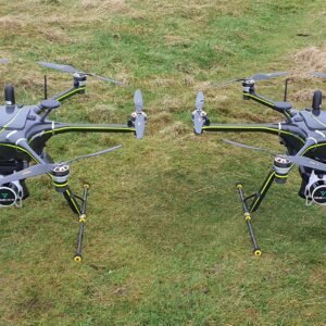
New Collaboration Enhances Aerial Surveying Capabilities with Integrated LiDAR and Software Solutions GeoCue has announced a new partnership with UK-based drone manufacturer Clogworks Technologies Limited. This collaboration integrates GeoCue’s TrueView LiDAR and LP360 software with Clogworks’ Dark Matter series of UAVs. The partnership aims to provide surveyors and mapping … [Read more...] about GeoCue and Clogworks Technologies Announce Partnership to Expand LiDAR Drone Mapping Solutions
Mastering Drone Mapping: Expert Tips for Success from SimActive’s Eric Andelin
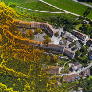
SimActive and Correlator3D™: A Closer Look Drone mapping has transformed industries by making geospatial data more accessible. However, achieving high-quality results requires both the right tools and the right approach. DRONELIFE.com interviewed Eric Andelin, Senior Workflow Specialist at SimActive, to uncover actionable tips for drone operators. SimActive, a leader in … [Read more...] about Mastering Drone Mapping: Expert Tips for Success from SimActive’s Eric Andelin
Drones Aid Disaster Recovery: Mapping and Photogrammetry Support Hurricane Helene Relief Efforts
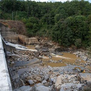
Drone mapping, photogrammetry aid recovery in wake of Helene devastation By DRONELIFE Features Editor Jim Magill (Part of a series on the drone community’s response to natural disasters) Hurricane Helene, the massive and deadly storm that tore through a large swath of the U.S. Southeast in late September, triggered a tremendous response from the drone-flying community, as … [Read more...] about Drones Aid Disaster Recovery: Mapping and Photogrammetry Support Hurricane Helene Relief Efforts
Sonoran Desert Institute Trains the Next Generation of Drone Operators for Disaster Response

Drones Are Becoming Essential Tools in Disaster Recovery and Preparedness By DRONELIFE Features Editor Jim Magill Drones are increasingly being deployed as a lifesaving tool in the response to natural disasters – as evidenced by the role UAVs have played in responding to a series of highly destructive hurricanes in the U.S. Southeast, and wildfires across the West. Helping … [Read more...] about Sonoran Desert Institute Trains the Next Generation of Drone Operators for Disaster Response


