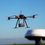
The following is a guest post from Dustin Price, licensed land surveyor and operations manager at Landpoint: a surveying, aerial data and technical services provider. There has been an influx of new and, in some cases, game-changing surveying technologies that have popped up over the past few years. Arguably the biggest of these technologies is unmanned aerial vehicles … [Read more...] about Surveying with Drones: The Key Differences Between Aerial LiDAR and Photogrammetry
- Skip to main content
- Skip to secondary menu
- Skip to primary sidebar
- Skip to secondary sidebar
- Skip to footer
DRONELIFE
Stay up to date on all the latest Drone News


