AirMap announces great step forward in UAS airspace safety for Intel powered drones; but promise is diminished by lack of roadmap for broader manufacturer compatibility. AirMap has announced Drone ID, a partnership with DigiCert that will enable instant authentication of an unmanned aircraft's identity via a digital certificate. Drone ID improves drone security, laying the … [Read more...] about AirMap and DigiCert Announce Drone ID Program for Enhanced Drone Security of Intel Drones
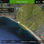
AirMap
Drone App Takes Flight at Kittyhawk
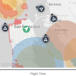
Drone-management firm Kittyhawk is hoping to live up to its aviation pioneering namesake with the launch of a new UAV air-traffic app. Partnering with Airmap, an airspace information service provider, San Francisco-based Kittyhawk has developed an iOS app that will allow users to receive live air-traffic alerts without exiting the app. Built on the Airmap platform, … [Read more...] about Drone App Takes Flight at Kittyhawk
NASA Testing BVLOS Flight in Reno
NASA took drones one step further towards integration into the NAS last week Recode reports, testing flight beyond visual line of sight (BVLOS) at the Reno, NV airport. BVLOS drone flight is not allowed under current regulations. The test was part of the research that NASA is doing in partnership with the FAA to develop a comprehensive unmanned air traffic control system, … [Read more...] about NASA Testing BVLOS Flight in Reno
US Gov Partners with DJI, Drone Industry
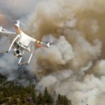
The US Department of the Interior has announced a collaboration with industry partners DJI, AirMap, and Skyward in an attempt to keep drones away from wildfires. In an announcement yesterday, the US Department of the Interior (DOI) says that they have released a prototype warning system with industry partners to provide real-time alerts and geofencing alarms to drone … [Read more...] about US Gov Partners with DJI, Drone Industry
AirMap, DJI Team Up to Corral Drone Wildfire Flights
A California-based company has teamed up with the world’s largest drone manufacturer to build an anti-drone fence around wildfires. AirMap, a provider of UAV airspace intelligence and navigation services, announced a partnership last week with DJI to enhance its current geofencing data database to include areas experiencing wildfires. Errant drones have become a real … [Read more...] about AirMap, DJI Team Up to Corral Drone Wildfire Flights


