• Skip to main content
  • Skip to secondary menu
  • Skip to primary sidebar
  • Skip to secondary sidebar
  • Skip to footer
  • DroneRacingLife
  • DroneFlyers
  • Newsletter
DroneLife

DRONELIFE

Stay up to date on all the latest Drone News

  • News
  • Products
  • Industries
    • Agriculture
    • Construction
    • Delivery
    • Dual Use
    • Inspection
    • Public Safety
    • Surveying
  • Enthusiasts
  • Regulations
  • Business
  • Video
  • Podcasts

Drone App Takes Flight at Kittyhawk

November 17, 2016 by Jason Reagan 1 Comment

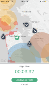
kittyhawkDrone-management firm Kittyhawk is hoping to live up to its aviation pioneering namesake with the launch of a new UAV air-traffic app.

Partnering with Airmap, an airspace information service provider, San Francisco-based Kittyhawk has developed an iOS app that will allow users to receive live air-traffic alerts without exiting the app.

Built on the Airmap platform, Kittyhawk’s new app – which bears the company’s name when searched in the Apple App Store – allows drone users to send a “digital notice” with data about their planned flight path to more than 150 airports and other UAV pilots.

“Kittyhawk had previously stayed away from providing in-flight intelligence, but the AirMap platform presented the right opportunity for us to work with another industry leader on creating an exceptionally useful feature,” Kittyhawk Chief Pilot Joshua Ziering said in a press release.

Other features of Kittyhawk include:

  • Live sharing of drone flights
  • FAA 333, Part 107, and drone hobbyist compliance features
  • Preflight module with hyper local weather and Kp index
  • Flight timers and stopwatch features

“The iOS app is the newest tool in our suite of technologies that allows people to communicate with our airspace management system,” AirMap co-founder Greg McNeal said.

“The AirMap ecosystem includes software integrations into DJI, 3DR, and Yuneec. It includes over 80 airports in the United States, including major hubs like Los Angeles International, Houston Intercontinental, and Denver International, as well as Air Force bases.”

Airmap is fast becoming a popular platform for drone-management solutions.  In May, the company released its own iOS app fueled by its proprietary Digital Notice and Awareness System (D-NAS).

The system allows drone users to transmit data to airports with real-time, digital geo-location information. Air-traffic professionals can then access the location data via the AirMap D-NAS dashboard, providing a map view of nearby drone flights.

In July, Airmap teamed up with DJI to enhance its current geofencing data database to include areas experiencing wildfires. The system gathers wildfire-location data directly from the Department of Interior and transmits it to drone pilots via its flight-control apps and AirMap’s geofencing system native to DJI’s GO flight control app.


Jason Reagan
Jason Reagan

Jason is a longstanding contributor to DroneLife with an avid interest in all things tech. He focuses on anti-drone technologies and the public safety sector; police, fire, and search and rescue.

Beginning his career as a journalist in 1996, Jason has since written and edited thousands of engaging news articles, blog posts, press releases and online content.

Email Jason
TWITTER:@JasonPReagan

LinkedIn 

Subscribe to DroneLife here.

Filed Under: Fire and Police, News Tagged With: Air Traffic Control, AirMap, drone management, Kittyhawk

Reader Interactions

Trackbacks

  1. Disney World To Launch 300-Drone Light Show | Drone "Ki" says:
    November 28, 2016 at 12:04 am

    […] Drone-management firm Kittyhawk is hoping to live up to its aviation pioneering namesake with the launch of a new UAV air-traffic app. Partnering with Airmap, an airspace information service provider, San Francisco-based Kittyhawk has developed an iOS app that will allow users to receive live air-traffic alerts without exiting the app. Built on the Airmap […] The post Drone App Takes Flight at Kittyhawk appeared first on DRONELIFE. See Original Article […]

    Reply

Leave a Reply Cancel reply

Your email address will not be published. Required fields are marked *

Primary Sidebar

LATEST

Blue Marble Geographics Introduces New Global Mapper Subscription for GIS and Drone Mapping

Three subscription tiers bring mapping, terrain analysis, lidar processing, and photogrammetry tools into a unified offering. Blue Marble Geographics has…

Continue Reading Blue Marble Geographics Introduces New Global Mapper Subscription for GIS and Drone Mapping

DOE Launches Battery Manufacturing Initiative to Strengthen U.S. Supply Chain

New national consortium aims to reduce production costs and speed commercialization of advanced batteries, including those used in drones. The…

Continue Reading DOE Launches Battery Manufacturing Initiative to Strengthen U.S. Supply Chain

FEMA’s $250 Million Counter-Drone Grant Deadline Approaches: Applications Due November 16

Nationwide funding supports counter-UAS capabilities for state and local agencies, but questions remain about whether the funding will meet demand.…

Continue Reading FEMA’s $250 Million Counter-Drone Grant Deadline Approaches: Applications Due November 16

Matternet Gains Access to More Than 2,300 North American Hospitals Through Swisslog Healthcare Partnership

New distribution agreement could give Matternet a competitive advantage in hospital drone delivery by leveraging an established healthcare sales network.…

Continue Reading Matternet Gains Access to More Than 2,300 North American Hospitals Through Swisslog Healthcare Partnership

FCC Opens 50 MHz of Cellular Spectrum for Drone Operations

New rules remove a decades-old restriction on airborne use of the 800 MHz Cellular band. The Federal Communications Commission (FCC)…

Continue Reading FCC Opens 50 MHz of Cellular Spectrum for Drone Operations

Zipline Announces Quieter Drone Deliveries as Communities Raise Noise Concerns

New flight software reduces modeled sound exposure by 68%, addressing a growing concern as drone delivery expands into residential areas.…

Continue Reading Zipline Announces Quieter Drone Deliveries as Communities Raise Noise Concerns

FCC Proposes New Rules for Drone Communications and Counter-Drone Radar

November vote would expand low-altitude aviation data links, support drone-detection radar, and update satellite connectivity rules. The Federal Communications Commission…

Continue Reading FCC Proposes New Rules for Drone Communications and Counter-Drone Radar

New State Drone Laws Create Patchwork of Restrictions, Raising Concerns for Operators

New restrictions in California, Arizona, and Alabama highlight differences in state regulations and raise questions about federal airspace authority. By…

Continue Reading New State Drone Laws Create Patchwork of Restrictions, Raising Concerns for Operators

ANRA Advances NATO-Tested Counter-Drone Technology With UTM Airspace Data

SIOP and TACO have advanced from TRL 5 to TRL 7. ANRA is now inviting U.S. sensor makers, integrators and…

Continue Reading ANRA Advances NATO-Tested Counter-Drone Technology With UTM Airspace Data

Basquevolt and Battera Technologies Partner on Lithium Metal Batteries for Aerospace Applications

The Spanish companies plan to combine Basquevolt’s lithium metal cells, which exceed 400 Wh/kg, with Battera’s pack integration, and they…

Continue Reading Basquevolt and Battera Technologies Partner on Lithium Metal Batteries for Aerospace Applications

Secondary Sidebar

Footer

SPONSORED

drone cleaning

Do Cleaning Drones Actually Work? 15 Apellix Before-and-After Jobs Show the Results

What Is the Best Commercial Cleaning Drone in 2026? Specs, Prices, and a Head-to-Head Comparison

Inspired Flight Gremsy IF800 VIO F1 drones geo week

What Will It Take to Strengthen U.S. Drone Manufacturing? A Conversation with Inspired Flight’s CEO

Global Mapper Mobile data collection

Collection Ground Control Points with Global Mapper Mobile

Military Drone Mapping Solutions

How SimActive’s Correlator3D™ is Revolutionizing Military Mapping: An Exclusive Interview with CEO Philippe Simard

Photogrammetry Accuracy Standards

SimActive Photogrammetry Software: Enabling Users to Meet Accuracy Standards for Over 20 Years

About Us | Contact Us | Advertise With Us | Write for Us | Privacy Policy | Terms of Service

The Trusted Source for the Business of Drones.

This website uses cookies and third party services. By clicking OK, you are agreeing to our privacy policy. ACCEPT

Manage consent

Privacy Overview

This website uses cookies to improve your experience while you navigate through the website. Out of these, the cookies that are categorized as necessary are stored on your browser as they are essential for the working of basic functionalities of the website. We also use third-party cookies that help us analyze and understand how you use this website. These cookies will be stored in your browser only with your consent. You also have the option to opt-out of these cookies. But opting out of some of these cookies may affect your browsing experience.
Necessary
Always Enabled
Necessary cookies are absolutely essential for the website to function properly. These cookies ensure basic functionalities and security features of the website, anonymously.
CookieDurationDescription
cookielawinfo-checkbox-analytics11 monthsThis cookie is set by GDPR Cookie Consent plugin. The cookie is used to store the user consent for the cookies in the category "Analytics".
cookielawinfo-checkbox-functional11 monthsThe cookie is set by GDPR cookie consent to record the user consent for the cookies in the category "Functional".
cookielawinfo-checkbox-necessary11 monthsThis cookie is set by GDPR Cookie Consent plugin. The cookies is used to store the user consent for the cookies in the category "Necessary".
cookielawinfo-checkbox-others11 monthsThis cookie is set by GDPR Cookie Consent plugin. The cookie is used to store the user consent for the cookies in the category "Other.
cookielawinfo-checkbox-performance11 monthsThis cookie is set by GDPR Cookie Consent plugin. The cookie is used to store the user consent for the cookies in the category "Performance".
viewed_cookie_policy11 monthsThe cookie is set by the GDPR Cookie Consent plugin and is used to store whether or not user has consented to the use of cookies. It does not store any personal data.
Functional
Functional cookies help to perform certain functionalities like sharing the content of the website on social media platforms, collect feedbacks, and other third-party features.
Performance
Performance cookies are used to understand and analyze the key performance indexes of the website which helps in delivering a better user experience for the visitors.
Analytics
Analytical cookies are used to understand how visitors interact with the website. These cookies help provide information on metrics the number of visitors, bounce rate, traffic source, etc.
Advertisement
Advertisement cookies are used to provide visitors with relevant ads and marketing campaigns. These cookies track visitors across websites and collect information to provide customized ads.
Others
Other uncategorized cookies are those that are being analyzed and have not been classified into a category as yet.
SAVE & ACCEPT