
Remote-operated “drone-in-a-box” system delivers weekly 2D and 3D data for construction monitoring Skyports Drone Services has partnered with HOCHTIEF to deploy an automated drone surveying system at a major bridge construction project in Germany. The deployment brings routine beyond visual line of sight (BVLOS) operations to the Rheinbrücke Leverkusen site near Cologne, … [Read more...] about Skyports Deploys Automated BVLOS Drone Surveys for Major German Bridge Project
aerial surveying
Can You Get Survey-Grade Accuracy Without Ground Control Points?
New Study Explores When Drone Mapping Can Reduce Ground Setup A new white paper from Swiss drone manufacturer Wingtra takes on a long-standing question in drone surveying: is it possible to achieve survey-grade accuracy without ground control points (GCPs)? The report, Repeat Accuracy Verification, presents results from 102 drone flights designed to test both accuracy and … [Read more...] about Can You Get Survey-Grade Accuracy Without Ground Control Points?
Wingcopter 198 Drones to Support Aerial Surveying in Japan

Wingcopter’s long-range Wingcopter 198 drone will be deployed for aerial surveying in Japan under a new collaboration between ITOCHU Corporation, PASCO Corporation, and YellowScan Japan Co., Ltd. The partners have signed an MOU to apply the platform to disaster management, terrain mapping, and post-event restoration tasks. The Wingcopter 198 combines vertical takeoff and … [Read more...] about Wingcopter 198 Drones to Support Aerial Surveying in Japan
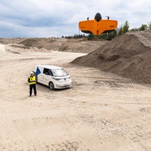
Wingtra Unveils WingtraRAY: A New Drone to Transform Aerial Surveying

The new platform offers faster workflows, safer urban operations, and broad payload flexibility for surveyors worldwide. Wingtra's new drone, WingtraRAY, designed to push the limits of aerial surveying and mapping. The WingtraRAY is built specifically for surveyors and promises to remove many of the operational barriers they face today. One major highlight is its ability to … [Read more...] about Wingtra Unveils WingtraRAY: A New Drone to Transform Aerial Surveying
Enhancing Drone Mapping with RTK and PPK: Insights from SimActive’s Eric Andelin

Drone mapping technology has advanced significantly in recent years, with Real-Time Kinematic (RTK) and Post-Processed Kinematic (PPK) positioning emerging as game-changing technologies. These methods enhance mapping accuracy and efficiency, reducing reliance on traditional Ground Control Points (GCPs). SimActive, a leading provider of photogrammetry software, offers powerful … [Read more...] about Enhancing Drone Mapping with RTK and PPK: Insights from SimActive’s Eric Andelin


