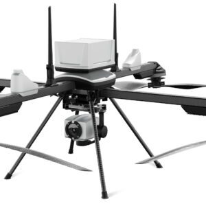
New Partnership Enhances UAV Mapping Capabilities ideaForge Technology Limited, an India-based global drone technology company, has announced a new partnership with Inertial Labs, a global leader in inertial sensors and GPS systems. This collaboration integrates Inertial Labs' RESEPI LiDAR solution into ideaForge's high-performance unmanned aerial vehicles (UAVs), representing … [Read more...] about India’s IdeaForge Integrates Inertial Lab’s LiDAR into Commercial UAV Solutions
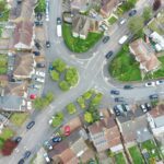
aerial mapping
Is Drone Mapping a First Amendment Right? This NC Lawsuit Has Major Implications for the Commercial Drone Industry
Is Drone Mapping the Same as Surveying, Which Requires a License and Board Certification? Institute for Justice Advocates for First Amendment Rights in North Carolina Drone Case In a recent development that could have far-reaching implications for commercial drone businesses, the non-profit Institute for Justice (IJ) presented oral arguments in a First Amendment case in … [Read more...] about Is Drone Mapping a First Amendment Right? This NC Lawsuit Has Major Implications for the Commercial Drone Industry
GeoCue Partners with Tediris to Integrate TrueView 3D Imaging with Aero 4 Drone
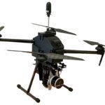
GeoCue and Tediris Solutions Partner to Provide Spain with Aerial Mapping Solutions by DRONELIFE Staff Writer Ian M. Crosby LiDAR mapping leader GeoCue has announced a new partnership with Spanish drone service provider Tediris Solutions. With close to a decade of experience in the UAV market, Tediris Solutions integrates sophisticated sensors, drones, and artificial … [Read more...] about GeoCue Partners with Tediris to Integrate TrueView 3D Imaging with Aero 4 Drone
SimActive and Phase One Cameras Collaborate for Streamlined Processing: Import Large Projects in Native Phase One IIQ Format
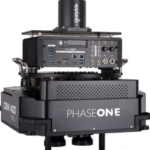
SimActive Inc. has announced the widespread adoption of its Correlator3D product by Phase One camera users across the globe. This collaboration simplifies data processing in aerial imaging applications, saving users time and optimizing output. Correlator3D, known for its ability to handle various imagery sources, now accommodates both small sensors like the IXM-50 commonly … [Read more...] about SimActive and Phase One Cameras Collaborate for Streamlined Processing: Import Large Projects in Native Phase One IIQ Format
Are Drones Always the Best Tool for the Job? Beacon Aviation Reduces Mapping Costs with SimActive
Integration of SimActive Photogrammetry Software Reduces Mapping Costs by DRONELIFE Staff Writer Ian M. Crosby Software developer SimActive has announced that its Correlator3D photogrammetry solution is to be utilized by Beacon Aviation, Inc. in order to lower costs required for mapping projects. Beacon, which operates throughout the Midwest, conducts mapping projects for … [Read more...] about Are Drones Always the Best Tool for the Job? Beacon Aviation Reduces Mapping Costs with SimActive


