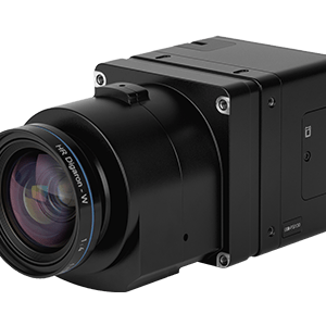
Phase One has announced the iXM-FS130, a next-generation aerial mapping camera designed to capture sub-centimeter ground sample distance imagery from fixed-wing aircraft at speeds exceeding 120 knots. The camera introduces Phase One's patented Fusion Shutter technology to the commercial aerial mapping market. This enables operators to maintain image quality while increasing … [Read more...] about Phase One Unveils iXM-FS130 Camera for Sub-Centimeter Aerial Mapping
Surveying
Wingcopter 198 Drones to Support Aerial Surveying in Japan

Wingcopter’s long-range Wingcopter 198 drone will be deployed for aerial surveying in Japan under a new collaboration between ITOCHU Corporation, PASCO Corporation, and YellowScan Japan Co., Ltd. The partners have signed an MOU to apply the platform to disaster management, terrain mapping, and post-event restoration tasks. The Wingcopter 198 combines vertical takeoff and … [Read more...] about Wingcopter 198 Drones to Support Aerial Surveying in Japan
SPH Engineering Adds 600 MHz UAV GPR Antennas for High-Resolution Subsurface Mapping
SPH Engineering has expanded its drone-based ground-penetrating radar (GPR) portfolio with two 600 MHz antennas designed for UAV integration: the MALÅ GeoDrone 600 and the Zond Aero 600 NG. The new systems are aimed at high-resolution subsurface mapping in engineering, utility detection, archaeology, environmental studies, and geophysical research, particularly where access for … [Read more...] about SPH Engineering Adds 600 MHz UAV GPR Antennas for High-Resolution Subsurface Mapping
From Intergeo 2025: Digital Twin Technology Preserves Alcatraz Island

A groundbreaking digital preservation project has created the most comprehensive 3D map of Alcatraz Island ever produced, combining cutting-edge drone technology, artificial intelligence, and reality capture systems to document one of America's most notorious historical sites. Pete Kelsey, founder of VCTO Labs, presented the remarkable achievements of this ambitious project at … [Read more...] about From Intergeo 2025: Digital Twin Technology Preserves Alcatraz Island
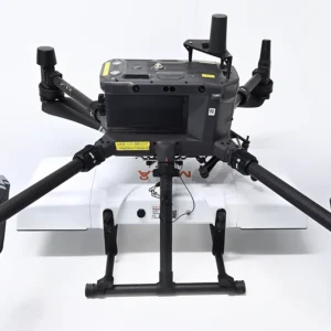
Orkid Unveils All-in-One Drone Combining LiDAR, Photogrammetry, GNSS, and Starlink

Orkid has announced a new variant of its ORKID 260 vertical take-off and landing (VTOL) drone, bringing together four of the most advanced aerial data capture technologies into one integrated, NDAA-compliant system. The ORKID 260VTOL integrated drone combines LiDAR, photogrammetry, GNSS, and Starlink satellite connectivity onboard, allowing all systems to operate … [Read more...] about Orkid Unveils All-in-One Drone Combining LiDAR, Photogrammetry, GNSS, and Starlink


