
• Skip to main content
  • Skip to secondary menu
  • Skip to primary sidebar
  • Skip to secondary sidebar
  • Skip to footer
  • DroneRacingLife
  • DroneFlyers
  • Newsletter
DroneLife

DRONELIFE

Stay up to date on all the latest Drone News

  • News
  • Products
  • Industries
    • Agriculture
    • Construction
    • Delivery
    • Dual Use
    • Inspection
    • Public Safety
    • Surveying
  • Enthusiasts
  • Regulations
  • Business
  • Video
  • Podcasts

China’s Anji County Expands A2Z Drone Network to 965 Square Miles

February 3, 2026 by Ian McNabb 1 Comment

Anji County outside Shanghai, China, has completed Phase 2 of its autonomous drone network expansion. The project added 19 A2Z AirDock stations, bringing the total to 34 docking stations across 965 square miles.

The network supports multiple drone fleets conducting interoperable missions throughout the region.

From 8 Docks to 34: Rapid Growth After Successful Trial

The expansion builds on a successful 2024 pilot program. The Anji Bureau of Water Resources initially deployed eight elevated AirDocks to automate routine waterway monitoring. Two A2Z Longtail Patrol drones hopped between charging stations, conducting nonstop autonomous patrols across 23 miles of contiguous waterways.

The results were dramatic. Traditional ground patrols took several days and missed hard-to-reach areas. The autonomous drone system reduced inspection time to just 1.5 hours.

“The initial phase of our AirDock network was transformative for our monitoring program,” said ChongShan Wan, Director of the Anji Bureau of Water Resources. “We realized significant savings in manpower and resources by conducting this monitoring from the air, so the decision to expand the project and reach beyond the urban center was an investment we had proven to be valuable.”

Early success prompted rapid expansion. The network quickly grew to 15 test locations to meet stakeholder demand before the formal Phase 2 buildout.

Shared Autonomous Drone Infrastructure Reduces Costs

The autonomous drone network now serves four governmental departments simultaneously. Each department shares the infrastructure, distributing capital costs across multiple budgets and improving project feasibility. New mission capabilities include highway inspection and search and rescue operations. Drones equipped with upgraded high-resolution and infrared cameras detect roadway cracks and debris from altitude. Other Longtail aircraft conduct repeatable search and rescue missions using infrared sensors.

The elevated AirDock design has a familiar, streetlight-like feel. In remote wooded locations, the elevated structures enable automatic charging and payload operations above tree level. Installation crews deployed up to three AirDocks per day during construction.
AI Detection Enhances Autonomous Drone Monitoring

A2Z engineers upgraded the Longtail Patrol’s onboard cameras to meet the precision requirements for roadway inspection. The system now performs AI-powered detection in real-time aboard the autonomous drone. Cloud-based AI comparison systems analyze waterway conditions. The technology identifies new algae blooms or pollutant indicators, automatically comparing current data against existing databases. The system records specific locations of potentially problematic sites and issues alerts to water inspectors for follow-up treatment.

“This process has greatly improved the efficiency of the water resource teams, allowing them to refocus their time on more urgent needs,” according to project documentation.

Local Restaurants Leverage Autonomous Drone Network for Delivery

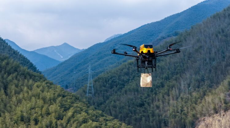
During government downtime, the autonomous drone network generates revenue for the county. Local restaurants use Longtail Cargo variants equipped with integrated commercial drone winches for last-mile food deliveries to area eco-resorts. Hotel guests order food through an app. Restaurant staff bring prepared orders to the closest AirDock. When the Longtail lands on the elevated platform, it lowers its winch to ground level. Staff load the food onto the delivery hook without requiring specialized training.

At the destination, the autonomous drone safely delivers orders from altitude. It automatically releases the payload as the winch lowers to the hotel or resort. The elevated AirDock design keeps spinning propellers far from ground personnel during loading and unloading operations.The expansion has enabled even more local restaurants and cafes to offer autonomous drone delivery across the 965-square-mile service area.

More information about A2Z is available from their website.

Read More
  • The Companies and Technologies Capturing the Counter-Drone Funding Surge
  • February Public Safety Drone Review: Gemma Alcock of SkyBound Joins the Conversation
  • News Media Coalition Letter Challenges FAA’s Expansive NOTAM
Ian McNabb

Ian McNabb is a journalist focusing on drone technology and lifestyle content at Dronelife. He is based between Boston and NH and, when not writing, enjoys hiking and Boston area sports.


Filed Under: Delivery, Drone News, Drone News Feeds, fleet management, Inspection, Long Range, Networking, News, Ports, Public Safety Tagged With: A2Z drone delivery, AI drone detection, AirDock, Anji County, autonomous drone network, BVLOS operations, China drone deployment, Commercial Drones, Drone Delivery, drone infrastructure, Drone Inspection, multi-mission drones, search and rescue drones, shared drone infrastructure, waterway monitoring

Reader Interactions

Comments

  1. Brooke says

    June 17, 2026 at 1:37 am

    While it’s fascinating to see how Anji County is successfully optimizing infrastructure costs by sharing the drone network across four government departments, I wonder how they manage data privacy and security with so many different agencies and third-party vendors involved? Specifically, regarding financial management and secure online transactions within these municipal-commercial frameworks, are they utilizing specialized fintech auditing standards similar to the technical frameworks discussed in guides like https://guiadebetsafeperu.com/ayuda/como-apostar to ensure operational transparency and risk mitigation?

    Reply

Leave a Reply Cancel reply

Your email address will not be published. Required fields are marked *

Primary Sidebar

LATEST

They Predicted a $127 Billion Drone Market. Ten Years Later, Here’s What They Got Right.

In 2016, Michael Mazur and Adam WiÅ›niewski helped author one of the drone industry’s most widely cited forecasts, putting the…

Continue Reading They Predicted a $127 Billion Drone Market. Ten Years Later, Here’s What They Got Right.

Beyond the Drone: What to See at INTERGEO 2026 in Munich

DRONELIFE heads to INTERGEO for a look at the mapping, lidar, photogrammetry, AI and digital twin technologies shaping the next…

Continue Reading Beyond the Drone: What to See at INTERGEO 2026 in Munich

Can Your Drone Program Survive Success? Why Simplicity Matters at Scale

SkyeBrowse CEO Bobby Ouyang says growing drone programs face a new challenge: making sophisticated capabilities simple enough to use across…

Continue Reading Can Your Drone Program Survive Success? Why Simplicity Matters at Scale

Batteries Were Boring. That Was a Feature. It’s Gone.

The shift toward a more secure domestic drone supply chain is forcing manufacturers to rethink components they once took for…

Continue Reading Batteries Were Boring. That Was a Feature. It’s Gone.

UK-Mined Lithium Passes Battery Test as Nations Push to Secure Critical Mineral Supply Chains

Cornish Lithium says lithium hydroxide produced and refined in Cornwall performed in line with, and in some areas better than,…

Continue Reading UK-Mined Lithium Passes Battery Test as Nations Push to Secure Critical Mineral Supply Chains

Missed the Moment? AirData Adds 10-Minute Rewind to Live Drone Video

New capabilities let remote teams recover missed moments, preserve mission video in the cloud and maintain a separate record from…

Continue Reading Missed the Moment? AirData Adds 10-Minute Rewind to Live Drone Video

Building American Drones Means Building the Parts, PDW CEO Says

James Slider says U.S. drone leadership will depend on domestic production of motors, batteries, electronics and other critical components By…

Continue Reading Building American Drones Means Building the Parts, PDW CEO Says

From Power Lines to Mine Shafts: Lidar Expands the Reach of Drone Mapping

Ouster partnerships with GeoCue and Flyability show how next-generation lidar is supporting applications above infrastructure and deep inside confined spaces…

Continue Reading From Power Lines to Mine Shafts: Lidar Expands the Reach of Drone Mapping

SimActive Adds Interactive Mode to Correlator3D for Faster Photogrammetry Workflows

The new interactive mode runs multiple scripts in a single session, cutting delays between operations for repetitive photogrammetry pipelines. SimActive…

Continue Reading SimActive Adds Interactive Mode to Correlator3D for Faster Photogrammetry Workflows

Texas Senators Call for Drone-Powered “Smart Wall”

By Dronelife Features Editor Jim Magill Facing threats from the federal government to build a border wall or other physical…

Continue Reading Texas Senators Call for Drone-Powered “Smart Wall”

Secondary Sidebar

Footer

SPONSORED

What Is the Best Commercial Cleaning Drone in 2026? Specs, Prices, and a Head-to-Head Comparison

Inspired Flight Gremsy IF800 VIO F1 drones geo week

What Will It Take to Strengthen U.S. Drone Manufacturing? A Conversation with Inspired Flight’s CEO

Global Mapper Mobile data collection

Collection Ground Control Points with Global Mapper Mobile

Military Drone Mapping Solutions

How SimActive’s Correlator3Dâ„¢ is Revolutionizing Military Mapping: An Exclusive Interview with CEO Philippe Simard

Photogrammetry Accuracy Standards

SimActive Photogrammetry Software: Enabling Users to Meet Accuracy Standards for Over 20 Years

NACT Engineering Parrot ANAFI tether indoor shot

Smart Tether for Parrot ANAFI USA from NACT Engineering

About Us | Contact Us | Advertise With Us | Write for Us | Privacy Policy | Terms of Service

The Trusted Source for the Business of Drones.

This website uses cookies and third party services. By clicking OK, you are agreeing to our privacy policy. ACCEPT

Manage consent

Privacy Overview

This website uses cookies to improve your experience while you navigate through the website. Out of these, the cookies that are categorized as necessary are stored on your browser as they are essential for the working of basic functionalities of the website. We also use third-party cookies that help us analyze and understand how you use this website. These cookies will be stored in your browser only with your consent. You also have the option to opt-out of these cookies. But opting out of some of these cookies may affect your browsing experience.
Necessary
Always Enabled
Necessary cookies are absolutely essential for the website to function properly. These cookies ensure basic functionalities and security features of the website, anonymously.
CookieDurationDescription
cookielawinfo-checkbox-analytics11 monthsThis cookie is set by GDPR Cookie Consent plugin. The cookie is used to store the user consent for the cookies in the category "Analytics".
cookielawinfo-checkbox-functional11 monthsThe cookie is set by GDPR cookie consent to record the user consent for the cookies in the category "Functional".
cookielawinfo-checkbox-necessary11 monthsThis cookie is set by GDPR Cookie Consent plugin. The cookies is used to store the user consent for the cookies in the category "Necessary".
cookielawinfo-checkbox-others11 monthsThis cookie is set by GDPR Cookie Consent plugin. The cookie is used to store the user consent for the cookies in the category "Other.
cookielawinfo-checkbox-performance11 monthsThis cookie is set by GDPR Cookie Consent plugin. The cookie is used to store the user consent for the cookies in the category "Performance".
viewed_cookie_policy11 monthsThe cookie is set by the GDPR Cookie Consent plugin and is used to store whether or not user has consented to the use of cookies. It does not store any personal data.
Functional
Functional cookies help to perform certain functionalities like sharing the content of the website on social media platforms, collect feedbacks, and other third-party features.
Performance
Performance cookies are used to understand and analyze the key performance indexes of the website which helps in delivering a better user experience for the visitors.
Analytics
Analytical cookies are used to understand how visitors interact with the website. These cookies help provide information on metrics the number of visitors, bounce rate, traffic source, etc.
Advertisement
Advertisement cookies are used to provide visitors with relevant ads and marketing campaigns. These cookies track visitors across websites and collect information to provide customized ads.
Others
Other uncategorized cookies are those that are being analyzed and have not been classified into a category as yet.
SAVE & ACCEPT



