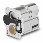
The Neutrino LC OGI Optical Gas Imaging Camera Imaging company Teledyne FLIR recently announced their new Neutrino LC OGI optical gas imaging camera module, an ITAR-free mid-wave infrared (MWIR) imager, made in the USA, designed to detect, measure, and visualize harmful gas emissions. The Neutrino LC OGI is perfect for compact, low-power applications like UAVs, small … [Read more...] about Detect, Measure, and Visualize Gas Emissions: Teledyne FLIR’s Neutrino LC OGI
Sensors
MatrixSpace Radar Gets FCC Approval: High Accuracy, Low SWaP-C for the Commercial Drone Industry

MatrixSpace Radar Receives FCC Authorization MatrixSpace, an impressive new provider of radio navigation services, announced on December 18, 2023, that its MatrixSpace Radar has received authorization from the Federal Communications Commission (FCC). The radar system, which has been rigorously tested to meet the FCC’s emissions and frequencies specifications, is now … [Read more...] about MatrixSpace Radar Gets FCC Approval: High Accuracy, Low SWaP-C for the Commercial Drone Industry
The Primer on Surveillance vs. Declaration vs. Operational Volume, for Advanced Drone Operations
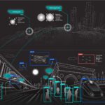
As advanced drone operations scale, stakeholders need greater understanding of ground-based surveillance systems (GBSS) and airspace awareness tools that enable autonomous, BVLOS operations: and the terms that describe their coverage relative to drone operations. Here, an expert from MatrixSpace explains Surveillance vs. Declaration vs. Operational volume. MatrixSpace is … [Read more...] about The Primer on Surveillance vs. Declaration vs. Operational Volume, for Advanced Drone Operations
The Art and Science of Low-Light Drone Operations: LiDAR or Camera? A DRONELIFE Exclusive from Immervision

Immervision is a leading provider of "Deep Seeing Technology": wide-angle optics, processing, and sensor fusion for next generation technology. Here, Immervision AVP Ludimila Centano gives a deep dive on the sensor options available for safe, low-light drone operations. Read on to understand the pros and cons of low-light cameras vs. LiDAR sensors, what actually qualifies as … [Read more...] about The Art and Science of Low-Light Drone Operations: LiDAR or Camera? A DRONELIFE Exclusive from Immervision
Skydio, Trimble Partner to Bring Centimeter Level Accuracy to the X10
Skydio and Trimble Collaborate on New Integration for Utilities, Construction and State Transportation Agencies by DRONELIFE Staff Writer Ian J. McNabb Skydio, a California-based drone and UAV manufacturer focused on autonomy, recently announced a new strategic partnership with Trimble to create new integrated workflows designed to unite data capture, data visualization, and … [Read more...] about Skydio, Trimble Partner to Bring Centimeter Level Accuracy to the X10


