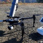
When drones encounter animals they normally end up on the losing side. Just look at the eagles being trained to take down stray UAVs, or what happens when an antelope takes a disliking to being watched from above. The bottom line is that most of the time, drones and wildlife simply shouldn't mix. It's an accident waiting to happen. But sometimes an accident is called for, … [Read more...] about Drone Volt Launches Drone to Locate and Destroy Asian Hornet
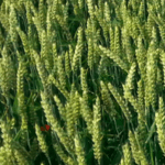
Agriculture
DroneDeploy Users Map 3,000,000 Acres
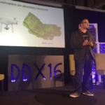
Guest post by by Darr Gerscovich, SVP Marketing @DroneDeploy This past Friday at the Drones Data X Conference in San Francisco, Mike Winn, co-founder and CEO of DroneDeploy, announced in his keynote that our users had achieved a new industry milestone: 3,000,000 drone mapped acres across 120 countries. Drones Are Transforming All Industries Drones combined with … [Read more...] about DroneDeploy Users Map 3,000,000 Acres
North Dakota State University Pioneers Drone Driven Agricultural Research
Late last month North Dakota State University (NDSU) launched an agricultural research project incorporating drone technology that was called “the first of its kind in the nation,” by Sreekala Bajwa, chair of NDSU’s Agricultural and Biosystems Engineering Department. The project is the most recent effort by NDSU to determine the role of UAS in agricultural production and … [Read more...] about North Dakota State University Pioneers Drone Driven Agricultural Research
DroneDeploy Unveils Integrated Drone Mapping
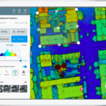
DroneDeploy, the California based cloud software platform for commercial drones, today announced a new release of its app that fully integrates its mapping experience across desktops and smartphones. Users can not only autonomously fly and capture images, but can also analyze their drone imagery directly from within the DroneDeploy app which is available for both Android and … [Read more...] about DroneDeploy Unveils Integrated Drone Mapping
Soil Sampling & Drone Mapping Combine to Deliver Better Prescriptions
Guest post By Anya Lamb, DroneDeploy — Planting is underway throughout most of the United States and many growers are excited to use drone mapping during the growing season. In the coming weeks, we look forward to showcasing several real-life examples of how growers are using drone mapping to help make better decisions. This week, we’re excited to share a case study showing … [Read more...] about Soil Sampling & Drone Mapping Combine to Deliver Better Prescriptions


