
Guest post By Anya Lamb, DroneDeploy —
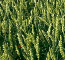 Planting is underway throughout most of the United States and many growers are excited to use drone mapping during the growing season. In the coming weeks, we look forward to showcasing several real-life examples of how growers are using drone mapping to help make better decisions.
This week, we’re excited to share a case study showing how drone imagery can be used in conjunction with soil sample data to demonstrate the relationship between soil conditions and crop health and recommend more efficient fertilizer prescriptions.
Soil Health: A New View
Landon Oldham is the owner of Heartland Soil Services (HSS), a company that collects and analyzes soil samples and then uses that data to estimate crop yield and make prescription maps for variable seed, fertilizer and nutrient application. With offices throughout Kansas, HSS customers include farmers, agronomists, cooperatives, and other companies.
Landon knows that while accurate, soil sample data lacks the granularity of aerial imagery. As more growers in the area started using drones for field mapping, a new question arose in his mind — can we use the correlation between soil conditions and crop health to develop better land management prescriptions?
The Project
Once Landon decided to test using drone imagery to help reveal trends between soil sample data and crop health, Landon selected an 80-acre field of winter wheat in Kingman County as the pilot field and enlisted the help of Sam Thier to capture aerial data.
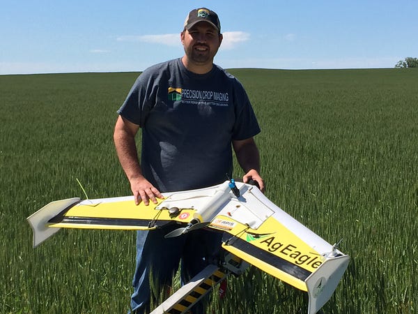
Sam, owner of Precision Crop Imaging, grew up in central Kansas helping out on his grandparents’ wheat farm and farming is close to his heart. He’s also always had a passion for aviation and has flown RC aircraft his whole life. When he first heard about drones being used to monitor crops, he realized right away that this was the path for him and started Precision Crop Imaging to fly and capture imagery for growers.
On a cloudy day in early April, Sam flew the field of winter wheat, by then about 4 or 5 inches tall. Even though the wind was gusting up to 40 mph — not uncommon for the area — Sam had no trouble flying his AgEagle Rapid to capture near-infrared NIR imagery. “That’s the beautiful thing about the AgEagle”, he said, “It was built to withstand the wind here in Kansas.”
Sam then uploaded his imagery to DroneDeploy. Once his map was complete, Sam shared it with Beau Dealy, of Apis Remote Sensing Systems, a Hays, Kansas-based drone service and solutions provider, to help him analyze the map and turn it into a format that Landon could use.
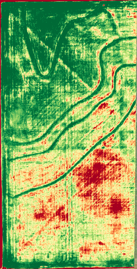
When Landon first saw the map, which uses NDVI (Normalized Difference Vegetation Index) to highlight differences in photosynthetic activity (plant health) throughout the field, he immediately recognized strong correlations between some of the soil sample data and the health of different areas of the new wheat crop.
“I was most surprised by how scarily similar the information was. The map showed that the issues we were seeing in the soil from our grid sample were also affecting the crop health.” — Landon Oldham, HSS [click to tweet]
A “Scarily” Close Correlation
When you look at the map of the wheat field, it’s clear to see areas of stress on the south (lower) and east (right) side of the map. NDVI mapping is great for this — giving a detailed view of where and to what extent a field is stressed — but it’s not as helpful for telling why the crop is stressed. For that, we turn to the soil sample data.
The first thing we notice in the soil maps, as in the drone map, is that the field is composed of two different sections with distinct characteristics. The northwestern (upper left) corner of the field sees more photosynthetic activity and also has a higher cation exchange capacity, which means it is more able to attract and retain nutrients. The southern portion of the field, even reaching up into the northeastern side, is characterized by less photosynthetic activity as well as a lower cation exchange capacity.
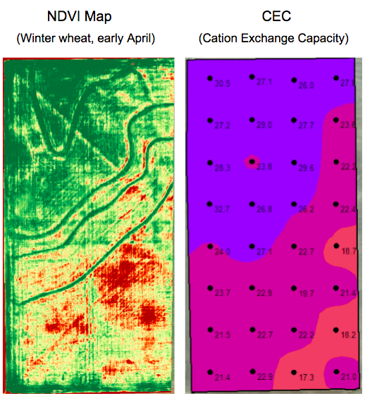
Another thing that’s notable is that although the entire field has high levels of calcium, the southern portion has extremely high levels of calcium, which are effectively taking up too much of the nutrient capacity of the soil, and not leaving enough room for other nutrients. The share of Magnesium and Potassium, for example, are below ideal levels. This could indicate the need to apply a prescription to the field.
Since Calcium and Magnesium are the two primary nutrients competing within the soil, the magnesium map is more or less an inversion of the Calcium maps, and both correlate very well to — and help explain — the two primary zones within the map. When we look at the Potassium map, we can begin to explain some of the more specific variation within the field. For example, even within the southern portion of the field, areas with higher levels of Potassium often seem to be healthier than those with lower levels.
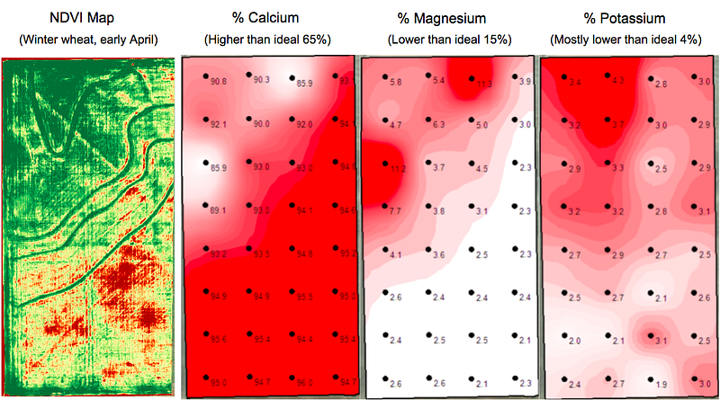
“From the map, we learned that our soil health strongly influences our crop health, and also helped validate our grid soil sample results!”, said Landon.
Landon, Sam and Beau plan to continue to investigate the relationship between soil characteristics and plant health as captured in drone imagery by continuing to monitor the field throughout the season and by testing their approach on more fields.
The Goal: More Efficient Fertilizer and Nutrient Applications
Given the promising results of the pilot study, Landon and Beau are excited to put their findings into action — by using the drone imagery to help make better nutrient prescription maps.
HSS already uses soil sample data to generate application recommendations for growers, but the challenge with using the soil maps alone to generate prescription maps is that there are relatively few data points — only one sample per couple of acres or so. By observing the correlation between an NDVI map showing plant health and the soil data, HSS hopes to infer soil conditions at a much more granular level, in order to make much more precise prescription maps.
“The workflow that we’re working towards,” said Beau, “is to sample the soil, and then use the flight as a follow-up to be able to refine your application”.
From what Landon sees, the NDVI map is teasing out the variations within the 2-acre grid. It lines up well with the soil information, but allows him to deliver a more accurate prescription.
Instead of generating a prescription map of general contours, Landon plans to use the drone imagery, combined with appropriate rates of nutrient application based on the soil sample data, to create a grid shapefile with sections that match the precision of the implement that will be used to apply the prescription. For example, if you’ve got a sprayer, and that has a boom width of about 120 feet, then you would want to set the tile size on the prescription shapefile to 120 feet.
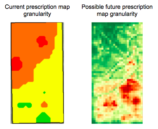
“It doesn’t matter if we’re talking about variable rates being put down per implement, per boom, per nozzle — we can zoom down to any level. Even the worst resolution we can get with DroneDeploy — 15 px/cm — that’s still at the cusp of the best resolution that the current equipment needs,” said Beau.
The benefit to growers is obvious — the more specific the application, the more efficient and effective it should be, giving growers the opportunity to save money by focusing applications on the areas that need them most.
“The ROI could be tremendous because growers could further increase the site-specific application of any and all products rather than flat rate applying the entire field at the exact same rate!” — Landon Oldham, HSS
Where to Learn More
Want to learn more about how you can use drone mapping on your farm? Check out our help center to learn more about the practices and tools mentioned in the case study, including:
- Using vegetation indices (NDVI) to detect crop stress
- Using NDVI data to define zones and grids
- Sharing and exporting your data

Frank Schroth is editor in chief of DroneLife, the authoritative source for news and analysis on the drone industry: it’s people, products, trends, and events.
Email Frank
TWITTER:@fschroth






Leave a Reply