
• Skip to main content
  • Skip to secondary menu
  • Skip to primary sidebar
  • Skip to secondary sidebar
  • Skip to footer
  • DroneRacingLife
  • DroneFlyers
  • Newsletter
DroneLife

DRONELIFE

Stay up to date on all the latest Drone News

  • News
  • Products
  • Industries
    • Agriculture
    • Construction
    • Delivery
    • Dual Use
    • Inspection
    • Public Safety
    • Surveying
  • Enthusiasts
  • Regulations
  • Business
  • Video
  • Podcasts

AIRT Puts Newly Released Pix4DReact to the Test After Hurricane Dorian

November 8, 2019 by Miriam McNabb 2 Comments

DRONELIFE got a first look at Pix4DReact at their user conference last month.  The software is designed to provide 2D mapping intelligence in the field – processing immediately, so that law enforcement, fire officials, or disaster recovery personnel can use the data to inform real-time critical decisions.

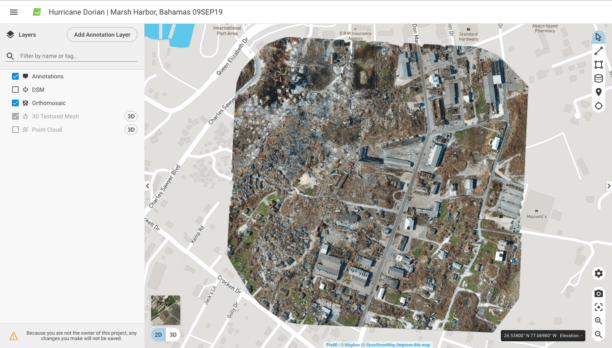
The Airborne International Response Team (AIRT) is a non-profit organization working with recovery teams and emergency management officials to provide aerial intelligence in disaster situations.  In the aftermath of  Hurricane Dorian, the AIRT team put Pix4DReact to the test.

The following taken from an AIRT and Pix4D press release.

Pix4Dreact has been field tested and validated by emergency teams operating drones for disaster response. The Miami-based Airborne International Response Team (AIRT) recently used Pix4Dreact for aerial mapping with drones in Marsh Harbour, Bahamas to help assess the devastation from major Category 5 Hurricane Dorian.

“We needed a solution that would allow us to rapidly process imagery on-scene under severe conditions with no available power source or mobile Internet connection,” says Christopher Todd who serves as the executive director of AIRT as well as a command staff member of the South Florida Region 7 All-Hazards Incident Management Team (FL-7 AHIMT).  “Pix4Dreact worked perfectly.  This software will help transform the workflow for disaster response teams around the world who are operating drones during emergencies.”

Unlike traditional mapping programs which typically require Internet access and can take several hours to render a map, Pix4D can rapidly and accurately process drone imagery directly on-scene without mobile connectivity.  Todd believes this will be a game changer for first responders and emergency services professionals who are operating drones.

“With the old workflow we needed to take the data off the drone, transport it back to a command post or emergency operations center, process the data – which might take several hours, and then push the end product back out to the field for use by response teams,” says Todd.  “Pix4Dreact allows responders to quickly process the data while still on-scene so it can be used much more quickly to help assess damage, protect property, and save lives.”

With a workflow that is intuitive and simple to use, Pix4Dreact’s fast-stitching technology creates accurate 2D orthomosaic maps by combining a large number of aerial nadir images from UAS.  Users can quickly measure, analyze, and mark these files, which are light enough to be easily sent via email as needed.

“We are excited that Pix4Dreact is now available for use by public safety and emergency services professionals around the world,” said Lorenzo Martelletti, Sales & Marketing Director, Pix4D.  “We will continue to work with first responders and disaster professionals to help make the product even stronger.”

A webinar highlighting Pix4Dreact and AIRT’s use of the software in their response to the Bahamas is scheduled for early December.  Pre-registration for the webinar is now open at https://forms.gle/R9FK39nXcRKoe7jd8.

For more information, to purchase or get a trial of Pix4Dreact, please visit: www.pix4d.com/react.

About AIRT

AIRT® (Airborne International Response Team) is a Florida-registered 501(c)3 non-profit organization that provides innovative aviation and aerospace resources to help prepare for, respond to, and recover from complex emergencies and major disasters. AIRT is building the World’s Largest Air Force® for #aviationforgood. Our global remote pilot network is ready to #getup whenever disaster strikes. For more information, visit: http://airt.ngo

About Pix4D

Pix4D is a dynamic and rapidly expanding software company with headquarters in Lausanne, Switzerland, and local offices in San Francisco, Denver, Shanghai, Berlin,Madridand Tokyo. The company develops a line of end-to-end mapping solutions which convert images into georeferenced maps, models and tangible information. Using advanced algorithms based on computer vision, photogrammetry and machine learning, Pix4D offers survey-grade accuracy, as well as a unique bundle of mobile drone flight execution, desktop and cloud processing.For more information visit: pix4d.com

 

Miriam McNabb

Miriam McNabb is the Editor-in-Chief of DRONELIFE and CEO of JobForDrones, a professional drone services marketplace, and a fascinated observer of the emerging drone industry and the regulatory environment for drones. Miriam has penned over 3,000 articles focused on the commercial drone space and is an international speaker and recognized figure in the industry.  Miriam has a degree from the University of Chicago and over 20 years of experience in high tech sales and marketing for new technologies.
For drone industry consulting or writing, Email Miriam.

TWITTER:@spaldingbarker

Subscribe to DroneLife here.

Filed Under: Feature 1, Fire, News Tagged With: AIRT, disaster response drones, Drones For Good, law enforcement drones, Pix4D

Reader Interactions

Trackbacks

  1. Parrot and AIRT: Manufacturer Partners with Public Safety Non-Profit | Gadgets says:
    July 7, 2020 at 4:16 am

    […] ANAFI Thermal: they’ve put Parrot company Pix4D‘s real time mapping product, Pix4dreact, to the test in the field.  The new ANAFI USA, with greater wind and weather resistance, should be a valuable addition in […]

    Reply
  2. AIRT Puts Newly Released Pix4DReact to the Test After Hurricane Dorian | Drone Magazine says:
    November 8, 2019 at 10:08 am

    […] Source […]

    Reply

Leave a Reply Cancel reply

Your email address will not be published. Required fields are marked *

Primary Sidebar

LATEST

U.S. Army Thermal Imaging Program Targets Next-Generation Drone Sensors

Teledyne FLIR OEM joins DUTCH initiative focused on performance, SWaP-C, and high-volume domestic production Teledyne FLIR OEM has been selected…

Continue Reading U.S. Army Thermal Imaging Program Targets Next-Generation Drone Sensors

Airbound Raises $37 Million Series A and Plans 10,000 Daily Drone Flights Across Andhra Pradesh

The Bengaluru aerospace startup, led by Greenoaks with DoorDash participation, targets a payload-to-aircraft ratio three times better than industry norms.…

Continue Reading Airbound Raises $37 Million Series A and Plans 10,000 Daily Drone Flights Across Andhra Pradesh

SkyDrive to Evaluate eVTOL Medical Logistics Routes in Mumbai, Delhi With Air India and Suzuki

The Japanese eVTOL developer identifies radioisotope transport, organ transport and airport parts logistics as priority use cases under the July…

Continue Reading SkyDrive to Evaluate eVTOL Medical Logistics Routes in Mumbai, Delhi With Air India and Suzuki

Quantum-Systems Opens Huntsville, Alabama Outpost

The U.S. subsidiary of the Quantum Systems Group opens a 3,200-square-foot engineering and R&D office in Huntsville’s Cummings Research Park…

Continue Reading Quantum-Systems Opens Huntsville, Alabama Outpost

Archer, AEG Plan Downtown Los Angeles Vertiport at L.A. LIVE

Proposed site would become the first announced downtown node in Archer’s planned Los Angeles air taxi network ahead of the…

Continue Reading Archer, AEG Plan Downtown Los Angeles Vertiport at L.A. LIVE

FCC Grants Conditional Approval for Ascento UAS

Ascento Guard Dori USA v1 joins a growing list of UAS exempted from the FCC Covered List through the federal…

Continue Reading FCC Grants Conditional Approval for Ascento UAS

New Survey Shows Just How Dependent Construction Is on Chinese Drones

ABC finds nearly all drone-using respondents rely primarily on DJI, highlighting the challenge of shifting to alternative platforms by DRONELIFE…

Continue Reading New Survey Shows Just How Dependent Construction Is on Chinese Drones

Cat-Inspired Claws Help Ice Dart Drone Land on Steep Ice

Université de Sherbrooke researchers demonstrate a new approach to landing multirotors on steep, irregular ice surfaces Cats may seem an…

Continue Reading Cat-Inspired Claws Help Ice Dart Drone Land on Steep Ice

Motorola Solutions Completes $1.5 Billion Acquisition of D-Fend Solutions

Counter-drone technology joins Motorola Solutions’ public safety portfolio as demand for airspace protection grows Motorola Solutions has completed its $1.5…

Continue Reading Motorola Solutions Completes $1.5 Billion Acquisition of D-Fend Solutions

Ondas Opens UAS Training and Operations Hub at Ohio’s NAAMCE

New Springfield facility will support long-endurance UAS training, testing and flight operations as Ondas expands its U.S. defense business Ondas…

Continue Reading Ondas Opens UAS Training and Operations Hub at Ohio’s NAAMCE

Secondary Sidebar

Footer

SPONSORED

What Is the Best Commercial Cleaning Drone in 2026? Specs, Prices, and a Head-to-Head Comparison

Inspired Flight Gremsy IF800 VIO F1 drones geo week

What Will It Take to Strengthen U.S. Drone Manufacturing? A Conversation with Inspired Flight’s CEO

Global Mapper Mobile data collection

Collection Ground Control Points with Global Mapper Mobile

Military Drone Mapping Solutions

How SimActive’s Correlator3D™ is Revolutionizing Military Mapping: An Exclusive Interview with CEO Philippe Simard

Photogrammetry Accuracy Standards

SimActive Photogrammetry Software: Enabling Users to Meet Accuracy Standards for Over 20 Years

NACT Engineering Parrot ANAFI tether indoor shot

Smart Tether for Parrot ANAFI USA from NACT Engineering

About Us | Contact Us | Advertise With Us | Write for Us | Privacy Policy | Terms of Service

The Trusted Source for the Business of Drones.

This website uses cookies and third party services. By clicking OK, you are agreeing to our privacy policy. ACCEPT

Manage consent

Privacy Overview

This website uses cookies to improve your experience while you navigate through the website. Out of these, the cookies that are categorized as necessary are stored on your browser as they are essential for the working of basic functionalities of the website. We also use third-party cookies that help us analyze and understand how you use this website. These cookies will be stored in your browser only with your consent. You also have the option to opt-out of these cookies. But opting out of some of these cookies may affect your browsing experience.
Necessary
Always Enabled
Necessary cookies are absolutely essential for the website to function properly. These cookies ensure basic functionalities and security features of the website, anonymously.
CookieDurationDescription
cookielawinfo-checkbox-analytics11 monthsThis cookie is set by GDPR Cookie Consent plugin. The cookie is used to store the user consent for the cookies in the category "Analytics".
cookielawinfo-checkbox-functional11 monthsThe cookie is set by GDPR cookie consent to record the user consent for the cookies in the category "Functional".
cookielawinfo-checkbox-necessary11 monthsThis cookie is set by GDPR Cookie Consent plugin. The cookies is used to store the user consent for the cookies in the category "Necessary".
cookielawinfo-checkbox-others11 monthsThis cookie is set by GDPR Cookie Consent plugin. The cookie is used to store the user consent for the cookies in the category "Other.
cookielawinfo-checkbox-performance11 monthsThis cookie is set by GDPR Cookie Consent plugin. The cookie is used to store the user consent for the cookies in the category "Performance".
viewed_cookie_policy11 monthsThe cookie is set by the GDPR Cookie Consent plugin and is used to store whether or not user has consented to the use of cookies. It does not store any personal data.
Functional
Functional cookies help to perform certain functionalities like sharing the content of the website on social media platforms, collect feedbacks, and other third-party features.
Performance
Performance cookies are used to understand and analyze the key performance indexes of the website which helps in delivering a better user experience for the visitors.
Analytics
Analytical cookies are used to understand how visitors interact with the website. These cookies help provide information on metrics the number of visitors, bounce rate, traffic source, etc.
Advertisement
Advertisement cookies are used to provide visitors with relevant ads and marketing campaigns. These cookies track visitors across websites and collect information to provide customized ads.
Others
Other uncategorized cookies are those that are being analyzed and have not been classified into a category as yet.
SAVE & ACCEPT




