
• Skip to main content
  • Skip to secondary menu
  • Skip to primary sidebar
  • Skip to secondary sidebar
  • Skip to footer
  • DroneRacingLife
  • DroneFlyers
  • Newsletter
DroneLife

DRONELIFE

Stay up to date on all the latest Drone News

  • News
  • Products
  • Industries
    • Agriculture
    • Construction
    • Delivery
    • Dual Use
    • Inspection
    • Public Safety
    • Surveying
  • Enthusiasts
  • Regulations
  • Business
  • Video
  • Podcasts

Helping Drones Navigate without GPS

September 25, 2026 by Jim Magill Leave a Comment

Massachusetts company Skyline Nav AI uses cameras and sensors to guide aircraft when GPS signals are blocked or disrupted

By DRONELIFE Features Editor Jim Magill

Since it first began to be widely adopted for commercial use in the 1980s, GPS technology has become ubiquitous, helping to facilitate the transportation of everything from passenger cars, to oceangoing ships, to drones.

But what happens when GPS signals are disrupted, by tall buildings, geological formations or by the deliberate use of jamming or spoofing technology by hostile actors?

That question led to the founding six years ago of Skyline Nav AI, a Boston area-based startup that produces low-cost GPS-independent visual positioning and navigation software for use in the defense and public safety sectors.

“GPS is a single point of failure in our modern society, and the blue dots that we get from the satellites, they’re very easy to jam and spoof,” Kanwar Singh, the company’s CEO, said in an interview. “The old technologies that we’d had as a society, as a country, as a civilization, were just not effective as they used to be.”

Singh, who serves as a captain in the Army National Guard in Massachusetts, observed the limitations of GPS technology in hot spots across the globe. He launched the company in 2020, after receiving a call from the Pentagon, seeking a solution to the growing problem of America’s adversaries disrupting the GPS signals of U.S. weapons systems.



“And at that time, we had never heard of this problem of GPS jamming that was happening. Now, this problem was quite significant in the wars in the Middle East, both Iraq and Afghanistan, but it was not publicly reported at the time,” he said.

With the evolution of battlefield tactics, which have come to increasingly rely on drone technology in conflicts from Ukraine to Iran, the problem of GPS-denial attacks has become even more acute.

“When the Ukraine war kicked off, GPS jamming became more critical, especially for the Ukrainian forces,” Singh said. “So that’s where we pivoted as a company into drones, but also GPS-independence for drones.”

Since its launch, Skyline has attracted a number of customers in the military, research and public safety sectors interested in its products designed to work in GPS-denied environments. Some of its customers include the U.S. Air Force, NASA, U.S. Army, BAE Systems, Kearfott Corporation, MassChallenge, MIT and Cornell University.

Non-GPS software and hardware solutions

The company’s drone-guidance technology deploys onboard cameras that scan the ground and inertial sensors that can determine the UAV’s location and flight path, dozens or hundreds of miles away from the operator. Skyline’s flagship Pathfinder series of products provides advanced computer vision and machine learning features in a lightweight, affordable unit.
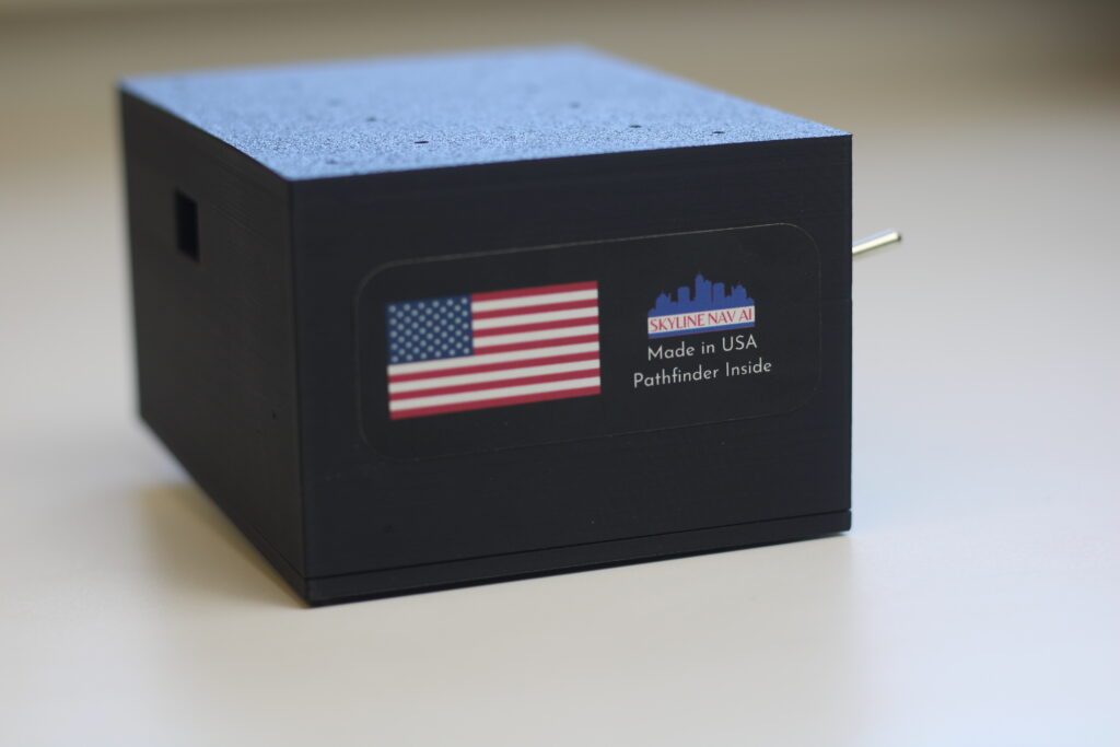
“With Pathfinder, we are able to make a dumb drone smart,” Singh said.

“Pathfinder comes in software but also hardware. On the software side, companies and organizations license it from us, and they put it on their platforms,” he said. “And on the hardware side, we have created a plug-and-play module that you can easily connect to a drone or aircraft or even ground platform, and then we are able to provide the location based on that.”

From its Massachusetts manufacturing facility, the company is able to produce 10,000 Pathfinder units a month, at a per-unit price as low as $1,000. Singh said the company eventually plans to grow its manufacturing capability, but currently is taking a go-slow approach to expansion.

“We don’t want to just grow for growth’s sake. We are deliberate about who we do business with, because there’s also the risk of our technology ending up in the wrong hands,” he said.

With its roots in the defense sector, the company prides itself on using U.S.-made components whenever possible, even though these tend to more expensive than foreign-made materials. Skyline has worked to establish a secure value chain to obtain components that are compliant with National Defense Authorization Act (NDAA) requirements.

“The problem ends up being the lead times. There’re still long lead times in certain items like computers or cameras or inertial sensors, but we have different suppliers who help us get that,” Singh said. “Unless the customers want us to work with cheaper parts, then we can also do that, but our preference is for NDAA compliance.”

In military applications, Skyline’s technology has been used for targeting and tracking in GPS-denied locations. On the commercial side it can provide precise latitude and longitude data in environments where GPS coverage is spotty, from mountainous rural terrain to the concrete canyons of urban centers.

“At a high level, what we do with our technology is we can help you navigate without GPS but then also help you get from point A to point B using cameras,” similar to the way in which Waymo and Tesla use camera systems to guide their terrestrial vehicles. Singh said.

Skyline’s team has expansive plans for the future of the company.

“We have a big goal, for every single platform that’s out there in the air, on land and on sea, that is reliant on GPS. We want to make them GPS-independent and autonomous,” he said. “Because that’s frankly what the country needs. That’s what our allies need. And so as long as those platforms are still reliant on GPS, that’s a problem, and we are on a mission to fix that.”

Read more:

  • DRONELIFE Exclusive Interview: Inside PDW’s Strategy to Build Drones That Can Operate When GPS and Communications Fail
  • Teledyne FLIR Defense Expands Payload Program with Emesent Hovermap for GPS-Denied Operations
  • Vermeer Secures $10 Million Series A to Advance GPS-Free Drone Navigation for Defense and Dual-Use Applications

 

Jim Magill

Jim Magill is a Houston-based writer with almost a quarter-century of experience covering technical and economic developments in the oil and gas industry. After retiring in December 2019 as a senior editor with S&P Global Platts, Jim began writing about emerging technologies, such as artificial intelligence, robots and drones, and the ways in which they’re contributing to our society. In addition to DroneLife, Jim is a contributor to Forbes.com and his work has appeared in the Houston Chronicle, U.S. News & World Report, and Unmanned Systems, a publication of the Association for Unmanned Vehicle Systems International


Filed Under: communications, connectivity, Drone News, Drone News Feeds, Featured, News Tagged With: defense drones, drone autonomy, drone navigation without GPS, GPS denied drones, GPS-Jamming, Pathfinder, Public Safety Drones, Skyline Nav AI, visual navigation

Reader Interactions

Leave a Reply Cancel reply

Your email address will not be published. Required fields are marked *

Primary Sidebar

LATEST

Senator Cites Classified Security Findings in Defense of DJI and Autel Restrictions

New FCC filings highlight company-specific national security concerns alongside broader supply chain risks behind the original Covered List decision. Senator…

Continue Reading Senator Cites Classified Security Findings in Defense of DJI and Autel Restrictions

Secure Connectivity: The Common Challenge for Drone Fleets and Counter-Drone Systems

How ZeroTier is helping operators maintain reliable, encrypted communications across commercial drone and counter-UAS applications. By DRONELIFE Features Editor Jim…

Continue Reading Secure Connectivity: The Common Challenge for Drone Fleets and Counter-Drone Systems

Federal Agencies Announce New Drone Flight Restrictions Along U.S.-Mexico Border

New airspace restrictions aim to counter unauthorized drone activity and protect border security operations, while limiting civilian drone flights near…

Continue Reading Federal Agencies Announce New Drone Flight Restrictions Along U.S.-Mexico Border

Automated BVLOS Drone Surveys Take on Major Infrastructure Project in Australia

Drone-in-a-box technology supports construction monitoring and improves site safety on the HumeLink West transmission project. Skyports Drone Services is using…

Continue Reading Automated BVLOS Drone Surveys Take on Major Infrastructure Project in Australia

ANRA Technologies Introduces VISTA for Shared Drone Airspace Awareness

The receive-only application shows nearby drone flight intent and reported positions from UTM services, so public safety and enterprise operators…

Continue Reading ANRA Technologies Introduces VISTA for Shared Drone Airspace Awareness

As Drone Delivery Expands, Community Pushback Becomes a Growing Challenge

Amazon’s proposed Massachusetts drone delivery hub faces congressional scrutiny, adding to concerns raised in other communities. Amazon’s plans to expand…

Continue Reading As Drone Delivery Expands, Community Pushback Becomes a Growing Challenge

Pentagon Details $450 Million Drone Dominance Competition as Gauntlet 2.5 Moves to November

Phase III raises production requirements and technical expectations, while a separate competition for reusable bomber drones faces a schedule change.…

Continue Reading Pentagon Details $450 Million Drone Dominance Competition as Gauntlet 2.5 Moves to November

U.S. Drone Manufacturers Expand International Defense Sales as Nepal Orders SPIRIT

Robinson Unmanned’s contract to supply the Nepali Army adds to recent international orders for U.S.-made military drone systems. Robinson Unmanned…

Continue Reading U.S. Drone Manufacturers Expand International Defense Sales as Nepal Orders SPIRIT

Drone Nose? Japanese Researchers Develop New Hydrogel To Combine Bug Antennae with Drones

This article published in collaboration with JUIDA, the Japan UAS Industrial Development Association.     Shinshu University and Chiba University researchers…

Continue Reading Drone Nose? Japanese Researchers Develop New Hydrogel To Combine Bug Antennae with Drones

Sumitomo Forestry and Mazex Expand Forestry Cargo Drones With Lower-Cost Karusuke Series

This article published in collaboration with JUIDA, the Japan UAS Industrial Development Association.     Sumitomo Forestry will introduce the Mazex…

Continue Reading Sumitomo Forestry and Mazex Expand Forestry Cargo Drones With Lower-Cost Karusuke Series

Secondary Sidebar

Footer

SPONSORED

drone cleaning

Do Cleaning Drones Actually Work? 15 Apellix Before-and-After Jobs Show the Results

What Is the Best Commercial Cleaning Drone in 2026? Specs, Prices, and a Head-to-Head Comparison

Inspired Flight Gremsy IF800 VIO F1 drones geo week

What Will It Take to Strengthen U.S. Drone Manufacturing? A Conversation with Inspired Flight’s CEO

Global Mapper Mobile data collection

Collection Ground Control Points with Global Mapper Mobile

Military Drone Mapping Solutions

How SimActive’s Correlator3D™ is Revolutionizing Military Mapping: An Exclusive Interview with CEO Philippe Simard

Photogrammetry Accuracy Standards

SimActive Photogrammetry Software: Enabling Users to Meet Accuracy Standards for Over 20 Years

About Us | Contact Us | Advertise With Us | Write for Us | Privacy Policy | Terms of Service

The Trusted Source for the Business of Drones.

This website uses cookies and third party services. By clicking OK, you are agreeing to our privacy policy. ACCEPT

Manage consent

Privacy Overview

This website uses cookies to improve your experience while you navigate through the website. Out of these, the cookies that are categorized as necessary are stored on your browser as they are essential for the working of basic functionalities of the website. We also use third-party cookies that help us analyze and understand how you use this website. These cookies will be stored in your browser only with your consent. You also have the option to opt-out of these cookies. But opting out of some of these cookies may affect your browsing experience.
Necessary
Always Enabled
Necessary cookies are absolutely essential for the website to function properly. These cookies ensure basic functionalities and security features of the website, anonymously.
CookieDurationDescription
cookielawinfo-checkbox-analytics11 monthsThis cookie is set by GDPR Cookie Consent plugin. The cookie is used to store the user consent for the cookies in the category "Analytics".
cookielawinfo-checkbox-functional11 monthsThe cookie is set by GDPR cookie consent to record the user consent for the cookies in the category "Functional".
cookielawinfo-checkbox-necessary11 monthsThis cookie is set by GDPR Cookie Consent plugin. The cookies is used to store the user consent for the cookies in the category "Necessary".
cookielawinfo-checkbox-others11 monthsThis cookie is set by GDPR Cookie Consent plugin. The cookie is used to store the user consent for the cookies in the category "Other.
cookielawinfo-checkbox-performance11 monthsThis cookie is set by GDPR Cookie Consent plugin. The cookie is used to store the user consent for the cookies in the category "Performance".
viewed_cookie_policy11 monthsThe cookie is set by the GDPR Cookie Consent plugin and is used to store whether or not user has consented to the use of cookies. It does not store any personal data.
Functional
Functional cookies help to perform certain functionalities like sharing the content of the website on social media platforms, collect feedbacks, and other third-party features.
Performance
Performance cookies are used to understand and analyze the key performance indexes of the website which helps in delivering a better user experience for the visitors.
Analytics
Analytical cookies are used to understand how visitors interact with the website. These cookies help provide information on metrics the number of visitors, bounce rate, traffic source, etc.
Advertisement
Advertisement cookies are used to provide visitors with relevant ads and marketing campaigns. These cookies track visitors across websites and collect information to provide customized ads.
Others
Other uncategorized cookies are those that are being analyzed and have not been classified into a category as yet.
SAVE & ACCEPT



