• Skip to main content
  • Skip to secondary menu
  • Skip to primary sidebar
  • Skip to secondary sidebar
  • Skip to footer
  • DroneRacingLife
  • DroneFlyers
  • Newsletter
DroneLife

DRONELIFE

Stay up to date on all the latest Drone News

  • News
  • Products
  • Industries
    • Agriculture
    • Construction
    • Delivery
    • Dual Use
    • Inspection
    • Public Safety
    • Surveying
  • Enthusiasts
  • Regulations
  • Business
  • Video
  • Podcasts

Elsight Launches HeatSight: Revolutionary Tool for Safer and Smarter UAV Flight Planning

January 22, 2025 by Miriam McNabb Leave a Comment

HeatSight Delivers Altitude-Based Cellular Coverage Mapping, Transforming BVLOS Connectivity and UAV Operations

by DRONELIFE Staff Writer Ian J. McNabb

Israeli-based Elsight, a company focused on unmanned connectivity solutions, announced today the launch of HeatSight, a revolutionary signal strength mapping tool which provides reliable data on cellular coverage for more effective and safer UAV flight planning. HeatSight is available to Elsight’s AllSight management platform customers.

HeatSight enables cellular coverage mapping of drone-flying altitudes by providing time- aggregated and altitude-based heatmaps, revealing where and when coverage thrives and where it falters across four dimensions (longitude, latitude, altitude, and time). Similarly to how a crowd-sourced traffic map can tell you when there’s a big slowdown ahead on the highway or where police have set up speed traps, HeatSight can help UAV operators detect where cellular signal coverage is stronger for safer and more reliable flights.

HeatSight cellular coverage mapping

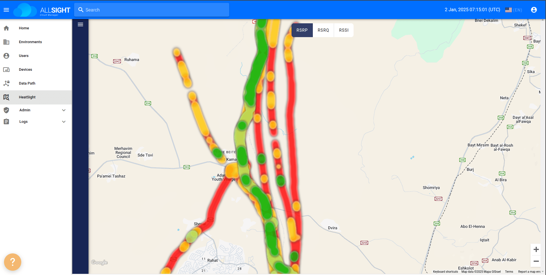
HeatSight leverages Elsight’s Beyond Visual Line-of-Sight (BVLOS) Halo connectivity technology to record multiple RF (Radio Frequency) parameters during every flight across varying cellular networks, altitudes, and times. Elsight’s AllSight Cloud Management platform can then take the uploaded data, where it is aggregated over time to provide a continuously evolving picture of the network coverage landscape.

“Think about using Waze to determine your best routes, HeatSight gives your UAV operators the data on the paths of strongest cellular coverage for your BVLOS missions,” said Yoav Amitai, CEO of Elsight. “It’s not only about static information, but operators may discover that certain areas are experiencing signal congestion during specific periods or weather conditions which would enable them to adjust mission flight paths or times for uninterrupted connectivity.”

“By producing a detailed and accurate data history of cellular coverage, HeatSight could simplify regulatory mandates dictating that UAV flights maintain ‘well-connected’ paths. Over time, HeatSight could be used as a revenue-generator tool for mobile operators to serve the UAV industry more effectively,” added Amitai.

More information on Elsight and their HeatSight software tool is available here. 

Want DRONELIFE news delivered to your inbox every weekday?  Sign up here.

Read more:

  • Elsight Recognized for Customer-Focused Approach in AFR’s 2024 Customer Champions List
  • Elsight Launches DroneCommX™, Extending Capabilities of DJI Matrice 30 and 350 Drones
  • Event 38, AviSight, and Elsight Collaborate for Enhanced BVLOS Pipeline Inspections
Miriam McNabb

Miriam McNabb is the Editor-in-Chief of DRONELIFE and CEO of JobForDrones, a professional drone services marketplace, and a fascinated observer of the emerging drone industry and the regulatory environment for drones. Miriam has penned over 3,000 articles focused on the commercial drone space and is an international speaker and recognized figure in the industry.  Miriam has a degree from the University of Chicago and over 20 years of experience in high tech sales and marketing for new technologies.
For drone industry consulting or writing, Email Miriam.

TWITTER:@spaldingbarker

Subscribe to DroneLife here.

Filed Under: Drone News, Drone News Feeds, News Tagged With: BVLoS technology, cellular coverage mapping, drone flight planning, Elsight AllSight, HeatSight, RF parameters, UAV Connectivity, UAV operations, UAV safety, Unmanned Aerial Systems

Reader Interactions

Leave a Reply Cancel reply

Your email address will not be published. Required fields are marked *

Primary Sidebar

LATEST

FCC Creates New Toy Drone Exemption While Defining a Low-Risk UAS Category

New FCC action removes certain toy drones from the Covered List and outlines the characteristics federal officials consider low risk.…

Continue Reading FCC Creates New Toy Drone Exemption While Defining a Low-Risk UAS Category

AirData Marks Energy and Utility Growth Milestone as BVLOS Rule Nears

The El Dorado Hills company says it now serves more than 120 energy and utility organizations globally and has logged…

Continue Reading AirData Marks Energy and Utility Growth Milestone as BVLOS Rule Nears

First DroneShield Products Roll Off Production Line in Europe

By Dronelife Features Editor Jim Magill Faced with growing challenges posed by drones flown by malicious actors, Western European nations…

Continue Reading First DroneShield Products Roll Off Production Line in Europe

European Defense Firms Partner on Sensor-to-Interceptor Counter-Drone Network

European companies combine detection, command-and-control, and interception technologies in layered air defense approach European counter-drone company Alpine Eagle and Latvian…

Continue Reading European Defense Firms Partner on Sensor-to-Interceptor Counter-Drone Network

From “Predictable Surprise” to Policy Priority: The Push for Faster Counter-Drone Deployment

As the planned attack on the White House highlights, drone threats are evolving faster than response capabilities. The reported disruption…

Continue Reading From “Predictable Surprise” to Policy Priority: The Push for Faster Counter-Drone Deployment

Japan Agriculture Drone Market Projected to Reach $357.8M by 2034

This article published in collaboration with JUIDA, the Japan UAS Industrial Development Association.   A new report from Tokyo-based Market Research…

Continue Reading Japan Agriculture Drone Market Projected to Reach $357.8M by 2034

WaiV Robotics Brings Autonomous Drone Recovery at Sea to U.S. Offshore Operators

As offshore energy assets move farther from shore, operators face growing challenges in inspection, maintenance, and emergency response. This week,…

Continue Reading WaiV Robotics Brings Autonomous Drone Recovery at Sea to U.S. Offshore Operators

Terra Drone Establishes Estonia-Based Defense Subsidiary to Support European Expansion

New company reflects broader shift from commercial drone services to defense and counter-drone systems Japan’s Terra Drone Corporation has established…

Continue Reading Terra Drone Establishes Estonia-Based Defense Subsidiary to Support European Expansion

NASA, UNOS and LifeNet Complete Successful BVLOS Drone Flights Carrying Human Kidneys

Study Examines Potential Role of Drones in Future Transplant Logistics All images, courtesy NASA. A new research collaboration between the…

Continue Reading NASA, UNOS and LifeNet Complete Successful BVLOS Drone Flights Carrying Human Kidneys

5 Federal Drone Policies Flying Under the Radar This Summer

From World Cup airspace restrictions to critical infrastructure rulemaking, several federal initiatives could shape the drone industry in the months…

Continue Reading 5 Federal Drone Policies Flying Under the Radar This Summer

Secondary Sidebar

Footer

SPONSORED

Inspired Flight Gremsy IF800 VIO F1 drones geo week

What Will It Take to Strengthen U.S. Drone Manufacturing? A Conversation with Inspired Flight’s CEO

Global Mapper Mobile data collection

Collection Ground Control Points with Global Mapper Mobile

Military Drone Mapping Solutions

How SimActive’s Correlator3D™ is Revolutionizing Military Mapping: An Exclusive Interview with CEO Philippe Simard

Photogrammetry Accuracy Standards

SimActive Photogrammetry Software: Enabling Users to Meet Accuracy Standards for Over 20 Years

NACT Engineering Parrot ANAFI tether indoor shot

Smart Tether for Parrot ANAFI USA from NACT Engineering

Blue Marble, features global mapper, features Blue Marble

Check Out These New Features in Global Mapper v25 from Blue Marble

About Us | Contact Us | Advertise With Us | Write for Us | Privacy Policy | Terms of Service

The Trusted Source for the Business of Drones.

This website uses cookies and third party services. By clicking OK, you are agreeing to our privacy policy. ACCEPT

Manage consent

Privacy Overview

This website uses cookies to improve your experience while you navigate through the website. Out of these, the cookies that are categorized as necessary are stored on your browser as they are essential for the working of basic functionalities of the website. We also use third-party cookies that help us analyze and understand how you use this website. These cookies will be stored in your browser only with your consent. You also have the option to opt-out of these cookies. But opting out of some of these cookies may affect your browsing experience.
Necessary
Always Enabled
Necessary cookies are absolutely essential for the website to function properly. These cookies ensure basic functionalities and security features of the website, anonymously.
CookieDurationDescription
cookielawinfo-checkbox-analytics11 monthsThis cookie is set by GDPR Cookie Consent plugin. The cookie is used to store the user consent for the cookies in the category "Analytics".
cookielawinfo-checkbox-functional11 monthsThe cookie is set by GDPR cookie consent to record the user consent for the cookies in the category "Functional".
cookielawinfo-checkbox-necessary11 monthsThis cookie is set by GDPR Cookie Consent plugin. The cookies is used to store the user consent for the cookies in the category "Necessary".
cookielawinfo-checkbox-others11 monthsThis cookie is set by GDPR Cookie Consent plugin. The cookie is used to store the user consent for the cookies in the category "Other.
cookielawinfo-checkbox-performance11 monthsThis cookie is set by GDPR Cookie Consent plugin. The cookie is used to store the user consent for the cookies in the category "Performance".
viewed_cookie_policy11 monthsThe cookie is set by the GDPR Cookie Consent plugin and is used to store whether or not user has consented to the use of cookies. It does not store any personal data.
Functional
Functional cookies help to perform certain functionalities like sharing the content of the website on social media platforms, collect feedbacks, and other third-party features.
Performance
Performance cookies are used to understand and analyze the key performance indexes of the website which helps in delivering a better user experience for the visitors.
Analytics
Analytical cookies are used to understand how visitors interact with the website. These cookies help provide information on metrics the number of visitors, bounce rate, traffic source, etc.
Advertisement
Advertisement cookies are used to provide visitors with relevant ads and marketing campaigns. These cookies track visitors across websites and collect information to provide customized ads.
Others
Other uncategorized cookies are those that are being analyzed and have not been classified into a category as yet.
SAVE & ACCEPT