• Skip to main content
  • Skip to secondary menu
  • Skip to primary sidebar
  • Skip to secondary sidebar
  • Skip to footer
  • DroneRacingLife
  • DroneFlyers
  • Newsletter
DroneLife

DRONELIFE

Stay up to date on all the latest Drone News

  • News
  • Products
  • Industries
    • Agriculture
    • Construction
    • Delivery
    • Dual Use
    • Inspection
    • Public Safety
    • Surveying
  • Enthusiasts
  • Regulations
  • Business
  • Video
  • Podcasts

Event 38 Unmanned Systems Incorporates Advanced LiDAR Technology into E455 Drone

February 15, 2024 by Miriam McNabb 4 Comments

Event 38 Unmanned Systems Integrates Advanced LiDAR onto E455 Drone

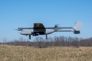
Event 38 Unmanned Systems, a global leader in the manufacturing of unmanned aerial vehicles, has announced a significant upgrade to their Heavy VTOL E455 Drone. The drone can now be equipped with multiple LiDAR systems, including the Resepi Hesai LIDAR XT-32 developed by Inertial Labs.

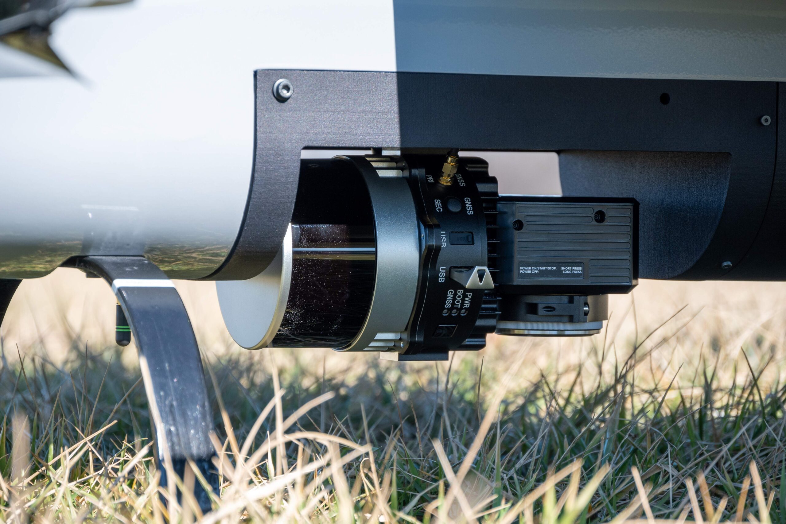
The integration of the Resepi Hesai LIDAR XT-32 onto the E455 Drone is now available to all Event 38 customers. This system is known for its best-in-class data accuracy, impressive detection range, high point density, and versatility, making it a top choice for professionals in the industry. The E455 will also carry NDAA Compliant LiDAR models from Inertial Labs, such as the RESEPI Ouster OS1-64.

RESEPI (Remote Sensing Payload Instrument) is a sensor-fusion platform designed for accuracy-focused remote sensing applications. It utilizes a high-performance Inertial Labs INS (GPS-Aided Inertial Navigation System) and a high-accuracy single or dual-antenna GNSS receiver, integrated with a Linux-based processing core and data-logging software.

Event38 LiDAR

The E455 stands out for its versatility and unique ability to carry heavier payloads. With Event 38’s LiDAR compatible systems, flight times extend beyond 2 hours, allowing for advanced operations and giving operators greater range and efficiency during each flight.

Jamie Marraccini, CEO of Inertial Labs, expressed enthusiasm about the partnership, stating, “By combining our advanced RESEPI Payload LiDAR with Event 38’s sophisticated E455 drone, we are setting a new standard for aerial surveying and mapping technology. This collaboration represents a leap forward in our mission to provide comprehensive, turnkey solutions that empower industries to achieve more.”

Jeff Taylor, CEO of Event 38 Unmanned Systems, added, “The high pulse rate and accuracy of the RESEPI Lidar systems paired with the E455 is a powerful combination giving operators the ability to collect thousands of acres of survey grade data in a single workday. It’s a new level of capability not previously available to our customers.”

Event 38 LiDAR

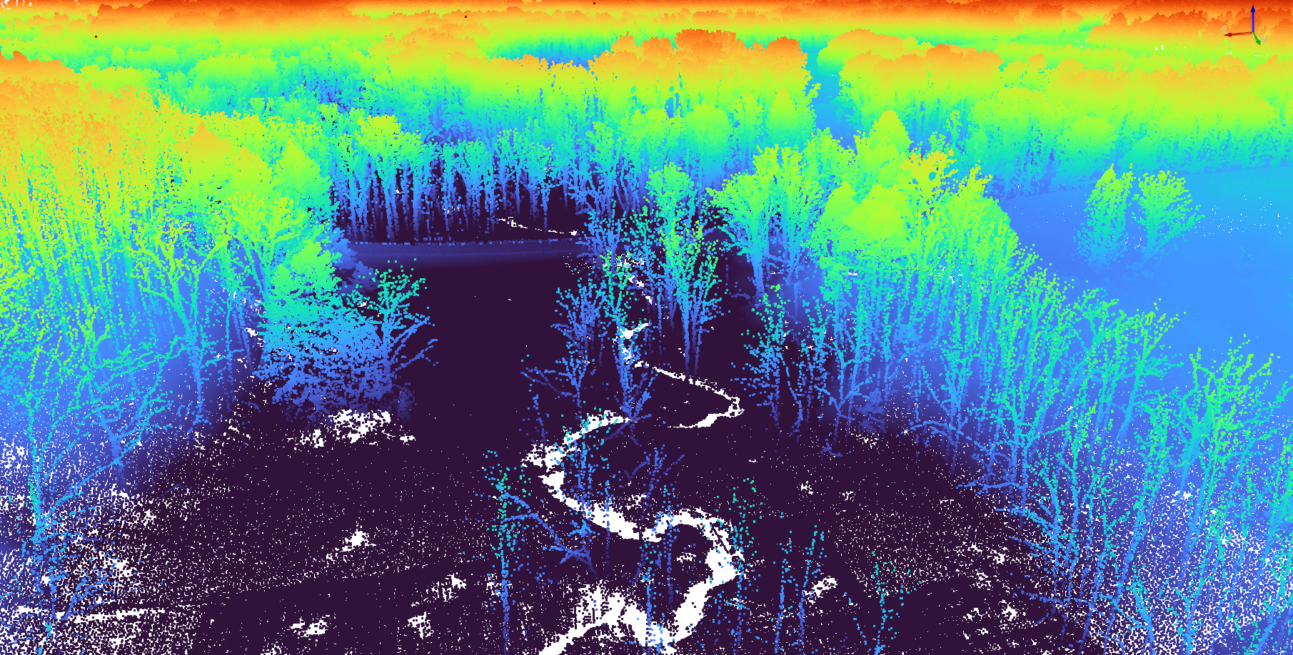
Event 38 has provided sample LiDAR data sets for customers here.

The new E455 with LiDAR is now available for purchase. Event 38 Unmanned Systems designs and manufactures fixed-wing VTOL drones in Richfield, Ohio. Since 2011, they have sold over 600 drones globally. Their drones capture geo-tagged data for a range of industries and applications and can be customized for high-resolution aerial photogrammetry, thermal and multispectral imagery, LiDAR, and live video streaming.

Read more:

  • Event 38 Releases New Variant of E400 ISR Drone: Longer Flight, Wider Range, and More
  • Mapping Paradise: Event 38 and PLACE Partner to Map Turks and Caicos
  • Event 38 Adds NextVision EO/IR Payload to E400 Fixed Wing Mapping Drone
Miriam McNabb

Miriam McNabb is the Editor-in-Chief of DRONELIFE and CEO of JobForDrones, a professional drone services marketplace, and a fascinated observer of the emerging drone industry and the regulatory environment for drones. Miriam has penned over 3,000 articles focused on the commercial drone space and is an international speaker and recognized figure in the industry.  Miriam has a degree from the University of Chicago and over 20 years of experience in high tech sales and marketing for new technologies.
For drone industry consulting or writing, Email Miriam.

TWITTER:@spaldingbarker

Subscribe to DroneLife here.

Filed Under: Drone News, Drone News Feeds, News, Products, Sensors, Surveying Tagged With: Advanced Drone Systems, aerial surveying, E455 Drone, Event 38 Unmanned Systems, Inertial Labs, Lidar technology, Mapping Technology, Remote Sensing Applications, RESEPI Payload, Unmanned Aerial Vehicles

Reader Interactions

Trackbacks

  1. Occasion 38 LiDAR Integration - DRONELIFE - Hello says:
    February 16, 2024 at 2:59 am

    […] Supply hyperlink […]

    Reply
  2. Occasion 38 LiDAR Integration - DRONELIFE - Enjbs says:
    February 15, 2024 at 9:25 pm

    […] Supply hyperlink […]

    Reply
  3. Occasion 38 Unmanned Techniques Incorporates Superior LiDAR Know-how into E455 Drone - TC Technology News says:
    February 15, 2024 at 11:21 am

    […] Supply hyperlink […]

    Reply
  4. Event 38 Unmanned Systems Incorporates Advanced LiDAR Technology into E455 Drone – Independent Drone Exchange says:
    February 15, 2024 at 11:20 am

    […] post Event 38 Unmanned Systems Incorporates Advanced LiDAR Technology into E455 Drone appeared first on […]

    Reply

Leave a Reply Cancel reply

Your email address will not be published. Required fields are marked *

Primary Sidebar

LATEST

ePropelled Expands Hercules Starter Generator Line With Scalable Hybrid Power for Drones

ePropelled has announced a major 2026 expansion of its Hercules starter generator product line. The update targets hybrid drone propulsion…

Continue Reading ePropelled Expands Hercules Starter Generator Line With Scalable Hybrid Power for Drones

Inside the Coachella Valley’s Plan to Centralize Drone First Responder Operations

By Dronelife Features Editor Jim Magill The Palm Springs, California Police Department is taking its Drones as First Responders (DFR)…

Continue Reading Inside the Coachella Valley’s Plan to Centralize Drone First Responder Operations

Teledyne FLIR OEM Upgrades Prism SKR Software for Autonomous Target Recognition

New release combines mission execution and intelligent supervision in a single autonomy platform Teledyne FLIR OEM has announced an upgrade…

Continue Reading Teledyne FLIR OEM Upgrades Prism SKR Software for Autonomous Target Recognition

Drone Operations Software Company AirHub Closes €4.4M Series A

AirHub, a European drone operations software company based in The Hague, has closed a €4.4 million Series A funding round.…

Continue Reading Drone Operations Software Company AirHub Closes €4.4M Series A

Arrive AI Patents Shared Drone Delivery Endpoint With Tenth U.S. Patent

Arrive AI (NASDAQ: ARAI) has secured its tenth U.S. patent, strengthening its intellectual property portfolio for autonomous drone delivery infrastructure.…

Continue Reading Arrive AI Patents Shared Drone Delivery Endpoint With Tenth U.S. Patent

Korean eVTOL Developer Airbility Partners on UAV Public Safety in Thailand

South Korean eVTOL developer Airbility has signed a four-party Memorandum of Understanding to deploy UAV systems for public safety and…

Continue Reading Korean eVTOL Developer Airbility Partners on UAV Public Safety in Thailand

Is U.S. Manufacturing the Answer? SKYROVER Signals a New Strategy as FCC Pressure Mounts

A Hong Kong-based drone company outlines a five-year U.S. roadmap, raising questions about compliance, supply chains, and market access A…

Continue Reading Is U.S. Manufacturing the Answer? SKYROVER Signals a New Strategy as FCC Pressure Mounts

Blue Marble Geographics and Avenza Systems Combine to Create Unified Geospatial Platform

Merger connects office-based analysis with field operations for end-to-end spatial workflows Blue Marble Geographics and Avenza Systems, Inc. have announced…

Continue Reading Blue Marble Geographics and Avenza Systems Combine to Create Unified Geospatial Platform

Amazon Prime Air Adjusts Course After Richardson Setbacks

After rocky start in Texas city, Amazon Air service flying high By DRONELIFE Features Editor Jim Magill After only a…

Continue Reading Amazon Prime Air Adjusts Course After Richardson Setbacks

Airspace Security at 2026 JUNO Awards

RF-Cyber counter-drone system enables non-disruptive protection for large public event D-Fend Solutions announced that its EnforceAir counter-drone system was deployed…

Continue Reading Airspace Security at 2026 JUNO Awards

Secondary Sidebar

Footer

SPONSORED

Inspired Flight Gremsy IF800 VIO F1 drones geo week

What Will It Take to Strengthen U.S. Drone Manufacturing? A Conversation with Inspired Flight’s CEO

Global Mapper Mobile data collection

Collection Ground Control Points with Global Mapper Mobile

Military Drone Mapping Solutions

How SimActive’s Correlator3D™ is Revolutionizing Military Mapping: An Exclusive Interview with CEO Philippe Simard

Photogrammetry Accuracy Standards

SimActive Photogrammetry Software: Enabling Users to Meet Accuracy Standards for Over 20 Years

NACT Engineering Parrot ANAFI tether indoor shot

Smart Tether for Parrot ANAFI USA from NACT Engineering

Blue Marble, features global mapper, features Blue Marble

Check Out These New Features in Global Mapper v25 from Blue Marble

About Us | Contact Us | Advertise With Us | Write for Us | Privacy Policy | Terms of Service

The Trusted Source for the Business of Drones.

This website uses cookies and third party services. By clicking OK, you are agreeing to our privacy policy. ACCEPT

Manage consent

Privacy Overview

This website uses cookies to improve your experience while you navigate through the website. Out of these, the cookies that are categorized as necessary are stored on your browser as they are essential for the working of basic functionalities of the website. We also use third-party cookies that help us analyze and understand how you use this website. These cookies will be stored in your browser only with your consent. You also have the option to opt-out of these cookies. But opting out of some of these cookies may affect your browsing experience.
Necessary
Always Enabled
Necessary cookies are absolutely essential for the website to function properly. These cookies ensure basic functionalities and security features of the website, anonymously.
CookieDurationDescription
cookielawinfo-checkbox-analytics11 monthsThis cookie is set by GDPR Cookie Consent plugin. The cookie is used to store the user consent for the cookies in the category "Analytics".
cookielawinfo-checkbox-functional11 monthsThe cookie is set by GDPR cookie consent to record the user consent for the cookies in the category "Functional".
cookielawinfo-checkbox-necessary11 monthsThis cookie is set by GDPR Cookie Consent plugin. The cookies is used to store the user consent for the cookies in the category "Necessary".
cookielawinfo-checkbox-others11 monthsThis cookie is set by GDPR Cookie Consent plugin. The cookie is used to store the user consent for the cookies in the category "Other.
cookielawinfo-checkbox-performance11 monthsThis cookie is set by GDPR Cookie Consent plugin. The cookie is used to store the user consent for the cookies in the category "Performance".
viewed_cookie_policy11 monthsThe cookie is set by the GDPR Cookie Consent plugin and is used to store whether or not user has consented to the use of cookies. It does not store any personal data.
Functional
Functional cookies help to perform certain functionalities like sharing the content of the website on social media platforms, collect feedbacks, and other third-party features.
Performance
Performance cookies are used to understand and analyze the key performance indexes of the website which helps in delivering a better user experience for the visitors.
Analytics
Analytical cookies are used to understand how visitors interact with the website. These cookies help provide information on metrics the number of visitors, bounce rate, traffic source, etc.
Advertisement
Advertisement cookies are used to provide visitors with relevant ads and marketing campaigns. These cookies track visitors across websites and collect information to provide customized ads.
Others
Other uncategorized cookies are those that are being analyzed and have not been classified into a category as yet.
SAVE & ACCEPT