Virtual Surveyor Releases New Photogrammetry App: Completing Drone Survey Workflow
Continue reading below, or listen:
by DRONELIFE Staff Writer Ian M. Crosby
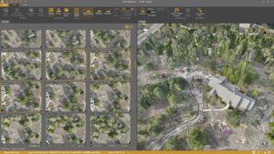
Software company Virtual Surveyor has updated the newest version of its smart drone surveying software to include drone photogrammetry functionality. Photos are processed through the new Terrain Creator app to generate survey-grade terrains to be transferred to the Virtual Surveyor workspace to conduct survey work.
“Virtual Surveyor software is now two desktop apps in one subscription package that create a seamless end-to-end drone survey workflow to save time and money,” said Virtual Surveyor CEO Tom Op ‘t Eyndt. “Terrain Creator removes complexity from the drone photogrammetry process, offering a visual and intuitive application to produce an orthomosaic and digital surface model (DSM) from drone photos.”
Virtual Surveyor software was designed to link drone photogrammetric processing applications and engineering design packages. Prior to this release, users were required to use third-party software to create elevation models and an orthomosaic to be worked on with the Virtual Surveyor toolset to obtain the necessary 3D topographic information.
“Drone surveyors no longer have to spend money on a third-party photogrammetry package to convert their drone photos into an orthomosaic and DSMs,” said Op ‘t Eyndt. “It just comes with our package, and the fully integrated workflow eliminates the time spent porting photogrammetry products from another package into Virtual Surveyor.”
In the Virtual Surveyor desktop app, users can leverage its toolsets to create CAD models, cut-and-fill maps and calculations, or calculate volume reports.
Those already subscribers to Virtual Surveyor Ridge and Peak editions will receive an automatic update to Version 9.0 with Terrain Creator. Additionally, a flexible licensing setup for subscribing organizations will enable two users to access the Terrain Creator and Virtual Surveyor applications at the same time on two different computers.
Virtual Surveyor will showcase its new release at InterGEO 2023 (Hall 1.2, Stand D1.030) on October 10-12 in Berlin, Germany, as well as other trade fairs this autumn.
Read more:
- Pix4D and Wingtra: New Integration Makes Orthomosaic and Point Cloud Generation 2X Faster
- Microsoft Collaborates with SimActive to Demonstrate a Cloud Photogrammetry Solution
- PPK for UAV Photogrammetry: the Optimal Workflow to Reduce GCP [Webinar]
- NDAA-Compliant LiDAR Drone Surveying System: Microdrones New EasyOne Solution
Ian attended Dominican University of California, where he received a BA in English in 2019. With a lifelong passion for writing and storytelling and a keen interest in technology, he is now contributing to DroneLife as a staff writer.
Miriam McNabb is the Editor-in-Chief of DRONELIFE and CEO of JobForDrones, a professional drone services marketplace, and a fascinated observer of the emerging drone industry and the regulatory environment for drones. Miriam has penned over 3,000 articles focused on the commercial drone space and is an international speaker and recognized figure in the industry. Miriam has a degree from the University of Chicago and over 20 years of experience in high tech sales and marketing for new technologies.
For drone industry consulting or writing, Email Miriam.
TWITTER:@spaldingbarker
Subscribe to DroneLife here.