• Skip to main content
  • Skip to secondary menu
  • Skip to primary sidebar
  • Skip to secondary sidebar
  • Skip to footer
  • DroneRacingLife
  • DroneFlyers
  • Newsletter
DroneLife

DRONELIFE

Stay up to date on all the latest Drone News

  • News
  • Products
  • Industries
    • Agriculture
    • Construction
    • Delivery
    • Dual Use
    • Inspection
    • Public Safety
    • Surveying
  • Enthusiasts
  • Regulations
  • Business
  • Video
  • Podcasts

The GLOBHE World Record for Largest Album of Drone-Collected Images: the Crowd-Droning Concept

March 22, 2022 by Miriam McNabb 24 Comments

Copyright image of Antarctica used with express permission of GLOBHE.

The GLOBHE world record for largest album of drone-collected images was achieved by “crowd-droning.”  Here’s how the concept can be used to help save the planet.

*Copyright images used with express permission from GLOBHE.

By Jim Magill

GLOBHE, a Stockholm Sweden-based company that collects data from drone operators across the globe, announced it has broken the world record for the most extensive digital album of images and data collected by drone.

In order to break the former record of compiling 20,000 photo images, GLOBHE, a combination of “global” and “health,” engaged in “crowd-droning,” enlisting its community of more than 5,000 drone operators in more than 96 countries.

By utilizing drones, which are able to shoot about 600 photos in 30 minutes, the company, in cooperation with its partners around the world, was able to accomplish the feat within a few months of taking on the Guinness challenge.

The GLOBHE World Record: Highlighting Climate Change

Content creator Emilia Nygren said GLOBHE took on the task of creating the record-breaking digital photo album to demonstrate the potential of its platform. “The digital album came about because we saw the potential in the number of pilots that we have all over the world connected to our network,” she said. “And we asked how can we activate as many of those pilots as possible and have as their mission to highlight their own local struggles with climate change.”

Participants in the Guinness world-record project — non-governmental organizations (NGOs), research labs and private companies involved in sustainability issues – were required to submit their proposed mapping projects, including how the project would further the goal of protecting the planet’s resources.

“It always has to have a purpose for a sustainable future,” Nygren said. For example, some projects used images shot by drones, rather than more expensive satellite imagery, to chart rising sea levels in out-of-the-way low-lying areas vulnerable to the devastating impacts of climate change.

From mid-December, when GLOBHE announced the Guinness initiative until late February, its collective of drone operators gathered more than 23,000 images, several thousand more than needed to top the previous record. The company then worked with Guinness and a third-party observer to evaluate the pictures, to ensure that they met the criteria for establishing the official world’s record.

Having collected all the images from this Guinness world-record attempt, GLOBHE will analyze the data collected and use it to create maps, which will benefit researchers and groups dealing with the myriad of issues surrounding climate change.

GLOBHE world record
Copyright image of Indonesia, used with express permission of GLOBHE.

Crowd-droning uses collective power

Crowd-droning leverages the power of the collective to achieve what an individual company or NGO could not accomplish on its own.

“Crowd-droning is like Uber for drones,” Nygren said. The company’s network of affiliated drone pilots is composed of professional UAS operators, rather than hobbyists. “We keep our standards very high, since we’ve focusing on the data you can get out of drones, not just the image itself,” she said.

GLOBHE collaborated with its drone pilot partners in choosing which individual projects are suitable for inclusion in the Guinness record attempt, with project ideas originating in some cases with the drone operators themselves and based on suggestions from the GLOBHE staff in other cases.

“It’s been a mixed bag,” Nygren said. “Some pilots or operators have come to us and said, ‘This is something that’s never covered by the media’ or ‘This is something that’s out of our local, little village and I want to map this particular thing.’ Other people have come to us and said ‘I want to be a part of this, but I don’t know exactly what I can map.’”

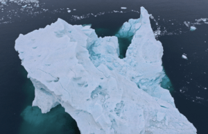
The project has resulted in the creation of some stunning images, showing the human toll of global warming. For example, a drone operator in Benin photographed the devastating impacts that rising sea levels have had on a small coastal village.

“The shoreline keeps shrinking and it keeps flooding every year. People have had to rebuild their house five or six times, because they can’t withstand the tides,” Nygren said. “You see these massive structures and it looks almost like ruins, but it’s all from the water damage. It’s quite drastic when you can see it from above.”

Another project portrays the effects of climate change in a region of Poland, which saw no January snowfalls.

“That’s quite rare and it’s affecting the seeds, and the fauna and flora,” Nygren said. “The snow is an essential part in the ecosystem of Poland. The leaves have to decompose underneath the snow, for everything to develop as it should during the spring and summer later on.”

Project requires high-resolution images

Participants in the Guinness digital album project were required to submit high-resolution photos, suitable for use in building ortho-mosaic maps. These maps in turn will be used by GLOBHE’s clients, including the United Nations and the Liverpool School of Tropical Medicine, in their research.

GLOBHE world record
Copyright image of Adelaide, Australia used with express permission of GLOBHE.

“You can’t just send up any sort of cheap drone. You don’t have to have a DJI Enterprise drone, because those are really expensive, but you do have to have one that can collect the high-resolution data we need,” Nygren said.

GLOBHE launched the digital album as a not-for-profit project aimed at mapping areas of the world that are frequently overlooked by researchers and the media, she said.

“We did it together with our pilots to measure issues that might not be on the mind of a lot of these NGOs or organizations that work with us,” Nygren said. “The world is very big and you can’t cover everything, but now we have data that we can show and hopefully that will spark questions and we will get a big response from it.”

Read more about GLOBHE:

  • Drones in Telecom: GLOBHE Signs Global Agreement
  • Swedish Company GLOBHE is Focused on Drones doing Good in Hard Hit Relief Areas
  • 8 Women in the Swiss Drone Industry Open Up About Diversity: How Far Weve Come, How Far to Go

Read more about drones in environmental protection:

  • Drones for Environmental Protection: Oceans Unmanned and The Ocean Cleanup Join Forces
  • Drones for the Environment: Battling Trash in San Francisco Estuaries
  • From Drone Light Shows to Environmental Conservation: UgCS Drone Fleet Software Helps Scientists Count Penguin Chicks

Jim Magill is a Houston-based writer with almost a quarter-century of experience covering technical and economic developments in the oil and gas industry. After retiring in December 2019 as a senior editor with S&P Global Platts, Jim began writing about emerging technologies, such as artificial intelligence, robots and drones, and the ways in which they’re contributing to our society. In addition to DroneLife, Jim is a contributor to Forbes.com and his work has appeared in the Houston Chronicle, U.S. News & World Report, and Unmanned Systems, a publication of the Association for Unmanned Vehicle Systems International.


Miriam McNabb

Miriam McNabb is the Editor-in-Chief of DRONELIFE and CEO of JobForDrones, a professional drone services marketplace, and a fascinated observer of the emerging drone industry and the regulatory environment for drones. Miriam has penned over 3,000 articles focused on the commercial drone space and is an international speaker and recognized figure in the industry.  Miriam has a degree from the University of Chicago and over 20 years of experience in high tech sales and marketing for new technologies.
For drone industry consulting or writing, Email Miriam.

TWITTER:@spaldingbarker

Subscribe to DroneLife here.

Filed Under: Drone News Feeds, News Tagged With: drone data, drone images, Drone Industry, drone pictures, Globe, GLOBHE

Reader Interactions

Trackbacks

  1. GLOBHE Drone Data – DRONELIFE – dmitralex.ru says:
    March 21, 2023 at 7:21 pm

    […] only 7 years ago – but they have already achieved a place in the Guinness Book of World Records (largest album of drone-collected images) and on the global stage of impact tech companies, those companies addressing major environmental […]

    Reply
  2. GLOBHE Drone Knowledge - DRONELIFE - top10-webhosting.com. All rights reserved. says:
    January 9, 2023 at 10:10 am

    […] – however they’ve already achieved a spot within the Guinness Guide of World Information (largest album of drone-collected pictures) and on the worldwide stage of influence tech firms, these firms addressing main environmental or […]

    Reply
  3. Datos de drones GLOBHE - DRONELIFE - NOTIS64 says:
    January 7, 2023 at 11:22 am

    […] hace solo 7 años, pero ya han logrado un lugar en el Libro Guinness de los récords mundiales (el álbum más grande de imágenes recopiladas por drones) y en el escenario world de las empresas de tecnología de impacto, aquellas empresas que abordan […]

    Reply
  4. GLOBHE Drone Knowledge - DRONELIFE says:
    January 7, 2023 at 10:25 am

    […] past – however they’ve already achieved a spot within the Guinness E book of World Data (largest album of drone-collected images) and on the worldwide stage of influence tech corporations, these corporations addressing main […]

    Reply
  5. GLOBHE Drone Information - DRONELIFE - NewsZusa says:
    January 7, 2023 at 6:02 am

    […] past – however they’ve already achieved a spot within the Guinness E-book of World Data (largest album of drone-collected photographs) and on the worldwide stage of impression tech firms, these firms addressing main environmental or […]

    Reply
  6. GLOBHE Drone Knowledge – DRONELIFE | Mds Policy says:
    January 7, 2023 at 2:49 am

    […] the past – however they’ve already achieved a spot within the Guinness Guide of World Data (largest album of drone-collected photographs) and on the worldwide stage of impression tech firms, these firms addressing main environmental or […]

    Reply
  7. GLOBHE Drone Information - DRONELIFE - Drones4Blazers says:
    January 7, 2023 at 2:35 am

    […] – however they’ve already completed a spot within the Guinness Ebook of International Data (biggest album of drone-collected photographs) and at the world level of have an effect on tech corporations, the ones corporations addressing […]

    Reply
  8. GLOBHE Drone Information - DRONELIFE - Natli Tech says:
    January 7, 2023 at 2:28 am

    […] – however they’ve already achieved a spot within the Guinness Guide of World Information (largest album of drone-collected photos) and on the worldwide stage of impression tech firms, these firms addressing main environmental or […]

    Reply
  9. GLOBHE Drönardata – DRONELIFE - Tjänadeg says:
    January 7, 2023 at 2:14 am

    […] startades för bara 7 år sedan – males de har redan nått en plats i Guinness världsrekordbok (största albumet med drönarinsamlade bilder) och på den globala scenen av effektteknikföretag, de företag som tar itu med stora miljö- […]

    Reply
  10. GLOBHE Drone Information - DRONELIFE - PureiTech says:
    January 7, 2023 at 1:45 am

    […] the past – however they’ve already achieved a spot within the Guinness Guide of World Data (largest album of drone-collected photographs) and on the worldwide stage of influence tech firms, these firms addressing main environmental or […]

    Reply
  11. GLOBHE Drone Knowledge - DRONELIFE - Tech Kloud says:
    January 7, 2023 at 1:01 am

    […] the past – however they’ve already achieved a spot within the Guinness Ebook of World Data (largest album of drone-collected images) and on the worldwide stage of affect tech corporations, these corporations addressing main […]

    Reply
  12. GLOBHE Drone Data - DRONELIFE - Fantastin says:
    January 7, 2023 at 12:39 am

    […] only 7 years ago – but they have already achieved a place in the Guinness Book of World Records (largest album of drone-collected images) and on the global stage of impact tech […]

    Reply
  13. GLOBHE Drone Knowledge – DRONELIFE – informatify.net says:
    January 6, 2023 at 6:00 pm

    […] – however they’ve already achieved a spot within the Guinness Guide of World Information (largest album of drone-collected images) and on the worldwide stage of influence tech corporations, these corporations addressing main […]

    Reply
  14. GLOBHE Drone Information - DRONELIFE - Top Gadget Hut says:
    January 6, 2023 at 5:54 pm

    […] – however they’ve already achieved a spot within the Guinness E book of World Information (largest album of drone-collected photographs) and on the worldwide stage of affect tech firms, these firms addressing main environmental or […]

    Reply
  15. GLOBHE: The Impact Tech Company Capturing Drone Data in Every Corner of the World | Gadgets says:
    January 6, 2023 at 3:14 pm

    […] only 7 years ago – but they have already achieved a place in the Guinness Book of World Records (largest album of drone-collected images) and on the global stage of impact tech companies, those companies addressing major environmental […]

    Reply
  16. The GLOBHE World Record for Largest Album of Drone-Collected Images: the Crowd-Droning Concept - DroneLife - Top Tyr Imaging says:
    August 2, 2022 at 11:30 pm

    […] source […]

    Reply
  17. The GLOBHE World Record for Largest Album of Drone-Collected Images: the Crowd-Droning Concept | UAV FL says:
    March 23, 2022 at 3:54 am

    […] post The GLOBHE World Record for Largest Album of Drone-Collected Images: the Crowd-Droning Concept appeared first on […]

    Reply
  18. GLOBHE World Record for Largest Album Drone Images – Game Up News says:
    March 23, 2022 at 3:09 am

    […] Source link […]

    Reply
  19. GLOBHE World Record for Largest Album Drone Images says:
    March 22, 2022 at 10:30 pm

    […] More… […]

    Reply
  20. The GLOBHE World Record for Largest Album of Drone-Collected Images: the Crowd-Droning Concept | taktik(z) GDI (Government Defense Infrastructure) says:
    March 22, 2022 at 7:17 pm

    […] post The GLOBHE World Record for Largest Album of Drone-Collected Images: the Crowd-Droning Concept appeared first on […]

    Reply
  21. GLOBHE World Record for Largest Album Drone Images - DRONELIFE - DroneLife - K드론팀 says:
    March 22, 2022 at 3:00 pm

    […] GLOBHE World Record for Largest Album Drone Images – DRONELIFE  DroneLife […]

    Reply
  22. The GLOBHE World Record for Largest Album of Drone-Collected Images: the Crowd-Droning Concept - silicon mirror says:
    March 22, 2022 at 1:43 pm

    […] Miriam McNabb is the Editor-in-Chief of DRONELIFE and CEO of JobForDrones, a professional drone services marketplace, and a fascinated observer of the emerging drone industry and the regulatory environment for drones. Miriam has penned over 3,000 articles focused on the commercial drone space and is an international speaker and recognized figure in the industry.  Miriam has a degree from the University of Chicago and over 20 years of experience in high tech sales and marketing for new technologies.For drone industry consulting or writing, Email Miriam. […]

    Reply
  23. The GLOBHE World Record for Largest Album of Drone-Collected Images: the Crowd-Droning Concept Miriam McNabb — DRONELIFE – Romulan News Channel says:
    March 22, 2022 at 1:39 pm

    […] […]

    Reply
  24. The GLOBHE World Record for Largest Album of Drone-Collected Images: the Crowd-Droning Concept – DronePilots.News says:
    March 22, 2022 at 1:24 pm

    […] post The GLOBHE World Record for Largest Album of Drone-Collected Images: the Crowd-Droning Concept appeared first on […]

    Reply

Leave a Reply Cancel reply

Your email address will not be published. Required fields are marked *

Primary Sidebar

LATEST

MatrixSpace Brings Portable Counter-Drone Radar to Lithuanian Exercise

The xTechCounter Strike winner deploys portable AI-powered radar to strengthen low-altitude airspace awareness for M-SHORAD units in Pabradė. MatrixSpace is…

Continue Reading MatrixSpace Brings Portable Counter-Drone Radar to Lithuanian Exercise

Industrial Policy and Wright’s Law: A New Perspective on Building the U.S. Drone Industry

At the AUVSI XPONENTIAL 2026 conference this week, Red Cat Holdings executive Brendan Stewart delivered one of the more historically…

Continue Reading Industrial Policy and Wright’s Law: A New Perspective on Building the U.S. Drone Industry

How DHS Is Helping World Cup Host Cities Get Counter-UAS Ready Before FIFA 2026

DHS lab equips World Cup cities with counter-drone guidance. By DRONELIFE Features Editor Jim Magill (Editor’s note: This is part…

Continue Reading How DHS Is Helping World Cup Host Cities Get Counter-UAS Ready Before FIFA 2026

Project ULTRA Aims to Normalize Drone Operations in Shared Airspace

FAA, DoD, and industry partners use Grand Forks test environment to develop scalable systems for UAS, logistics, and counter-UAS coordination…

Continue Reading Project ULTRA Aims to Normalize Drone Operations in Shared Airspace

Michigan’s Bet on the Low Altitude Economy: How M Air Connects Aerospace Innovation and Detroit Manufacturing

At XPONENTIAL 2026 this week, leaders from University of Michigan outlined an ambitious vision for the future of drones and…

Continue Reading Michigan’s Bet on the Low Altitude Economy: How M Air Connects Aerospace Innovation and Detroit Manufacturing

CVS, SkyfireAI, and Thales Outline Drone-Based Healthcare Response Network at XPONENTIAL 2026

Panel highlights healthcare logistics, emergency response, and disaster resilience as key drone use cases At the XPONENTIAL 2026 conference in…

Continue Reading CVS, SkyfireAI, and Thales Outline Drone-Based Healthcare Response Network at XPONENTIAL 2026

Drone Dominance: The Defense Department’s Push to Build a Scalable U.S. Drone Supply Chain

At this morning’s keynote roundtable at XPONENTIAL 2026, government and industry leaders outlined a new phase in the effort to…

Continue Reading Drone Dominance: The Defense Department’s Push to Build a Scalable U.S. Drone Supply Chain

From The Floor of XPONENTIAL: AIRO and Jaunt Reveal Dual-Use VTOL Aircraft for Defense and Cargo Missions

Jaunt Air Mobility’s autonomous slowed-rotor platform targets defense ISR, cargo logistics, and remote operations in two mission variants. AIRO Group…

Continue Reading From The Floor of XPONENTIAL: AIRO and Jaunt Reveal Dual-Use VTOL Aircraft for Defense and Cargo Missions

SkyDrive Signs First Japanese Helicopter Operator for SD-05 eVTOL

Tohoku Air Service, owned by Tohoku Electric Power, signs a letter of intent for one SKYDRIVE SD-05 with delivery targeted…

Continue Reading SkyDrive Signs First Japanese Helicopter Operator for SD-05 eVTOL

At XPONENTIAL 2026, AUVSI Signals a New Phase for the Drone Industry

AUVSI’s XPONENTIAL 2026 Message: The Drone Industry Moves From Innovation to Integration At XPONENTIAL 2026 in Detroit this week, President…

Continue Reading At XPONENTIAL 2026, AUVSI Signals a New Phase for the Drone Industry

Secondary Sidebar

Footer

SPONSORED

Inspired Flight Gremsy IF800 VIO F1 drones geo week

What Will It Take to Strengthen U.S. Drone Manufacturing? A Conversation with Inspired Flight’s CEO

Global Mapper Mobile data collection

Collection Ground Control Points with Global Mapper Mobile

Military Drone Mapping Solutions

How SimActive’s Correlator3D™ is Revolutionizing Military Mapping: An Exclusive Interview with CEO Philippe Simard

Photogrammetry Accuracy Standards

SimActive Photogrammetry Software: Enabling Users to Meet Accuracy Standards for Over 20 Years

NACT Engineering Parrot ANAFI tether indoor shot

Smart Tether for Parrot ANAFI USA from NACT Engineering

Blue Marble, features global mapper, features Blue Marble

Check Out These New Features in Global Mapper v25 from Blue Marble

About Us | Contact Us | Advertise With Us | Write for Us | Privacy Policy | Terms of Service

The Trusted Source for the Business of Drones.

This website uses cookies and third party services. By clicking OK, you are agreeing to our privacy policy. ACCEPT

Manage consent

Privacy Overview

This website uses cookies to improve your experience while you navigate through the website. Out of these, the cookies that are categorized as necessary are stored on your browser as they are essential for the working of basic functionalities of the website. We also use third-party cookies that help us analyze and understand how you use this website. These cookies will be stored in your browser only with your consent. You also have the option to opt-out of these cookies. But opting out of some of these cookies may affect your browsing experience.
Necessary
Always Enabled
Necessary cookies are absolutely essential for the website to function properly. These cookies ensure basic functionalities and security features of the website, anonymously.
CookieDurationDescription
cookielawinfo-checkbox-analytics11 monthsThis cookie is set by GDPR Cookie Consent plugin. The cookie is used to store the user consent for the cookies in the category "Analytics".
cookielawinfo-checkbox-functional11 monthsThe cookie is set by GDPR cookie consent to record the user consent for the cookies in the category "Functional".
cookielawinfo-checkbox-necessary11 monthsThis cookie is set by GDPR Cookie Consent plugin. The cookies is used to store the user consent for the cookies in the category "Necessary".
cookielawinfo-checkbox-others11 monthsThis cookie is set by GDPR Cookie Consent plugin. The cookie is used to store the user consent for the cookies in the category "Other.
cookielawinfo-checkbox-performance11 monthsThis cookie is set by GDPR Cookie Consent plugin. The cookie is used to store the user consent for the cookies in the category "Performance".
viewed_cookie_policy11 monthsThe cookie is set by the GDPR Cookie Consent plugin and is used to store whether or not user has consented to the use of cookies. It does not store any personal data.
Functional
Functional cookies help to perform certain functionalities like sharing the content of the website on social media platforms, collect feedbacks, and other third-party features.
Performance
Performance cookies are used to understand and analyze the key performance indexes of the website which helps in delivering a better user experience for the visitors.
Analytics
Analytical cookies are used to understand how visitors interact with the website. These cookies help provide information on metrics the number of visitors, bounce rate, traffic source, etc.
Advertisement
Advertisement cookies are used to provide visitors with relevant ads and marketing campaigns. These cookies track visitors across websites and collect information to provide customized ads.
Others
Other uncategorized cookies are those that are being analyzed and have not been classified into a category as yet.
SAVE & ACCEPT