• Skip to main content
  • Skip to secondary menu
  • Skip to primary sidebar
  • Skip to secondary sidebar
  • Skip to footer
  • DroneRacingLife
  • DroneFlyers
  • Newsletter
DroneLife

DRONELIFE

Stay up to date on all the latest Drone News

  • News
  • Products
  • Industries
    • Agriculture
    • Construction
    • Delivery
    • Dual Use
    • Inspection
    • Public Safety
    • Surveying
  • Enthusiasts
  • Regulations
  • Business
  • Video
  • Podcasts

Enterprise Scale: DJI Introduces New P4 Multispectral for Precision Agriculture and Land Management

September 24, 2019 by Miriam McNabb 11 Comments

At DJI Airworks this morning, DJI announced a new integrated tool to take precision agriculture to the next level: the P4 Multispectral, a totally integrated multispectral imaging drone.  Jan Gasparic, DJI’s Director of Strategic Partnerships, told a group of media professionals yesterday that the new offering represents a push forward in precision agriculture.  “Historically, farmers have faced significant challenges in adopting new technologies,” says Gasparic.  “Technology needs to be easy to use.”

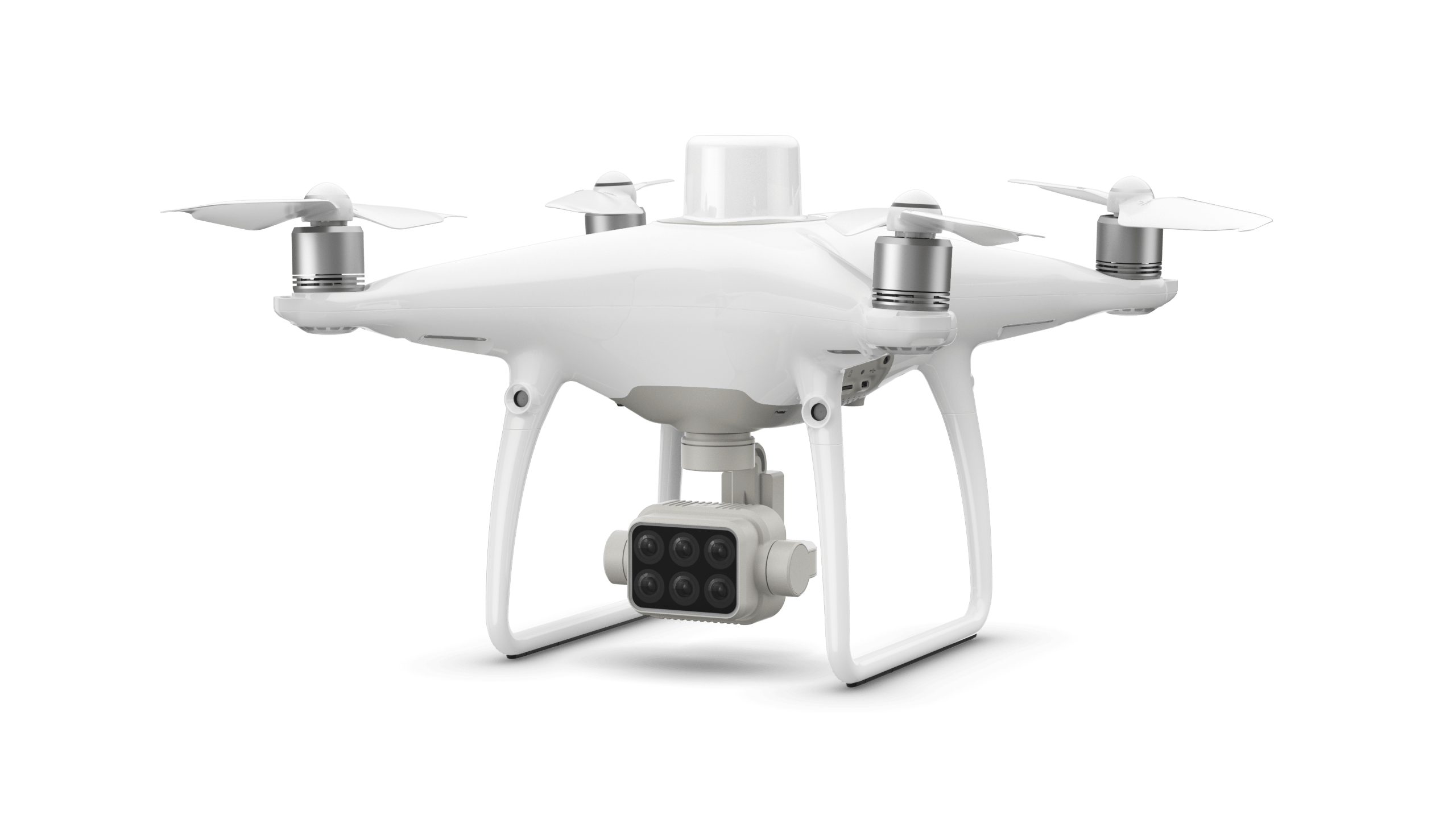
 The totally integrated 6 band camera on the proven P4 platform brings that ease of use to the field.  On top of the drone is a sunlight sensor that captures ambient sunlight, which gives more accurate and consistent data.

There are 3 major benefits to agronomists to using drone data, explains Gasparic: “You can scout fields in less time.  You can see the unseen.  And you can make decisions mid-season.” Gasparic points out that the data quality from drones is far better than that from satellites: it’s not only a closer view, but the data can be available in reat time.  Gasparic showed an impressive demonstration of a field map produced by DJI partner DroneDeploy, using their LiveMap technology: processed in real time so that the farmer on the field edge has immediate access to the usable data.  Taking the stage at AirWorks this morning, DroneDeploy CEO Mike Winn says his company has been doing precision agriculture since 2014 – and “What’s exciting about agriculture now is the scale,” says Winn.  DroneDeploy makes drone software – and with 5,000 customers performing over 1 million flights per year and mapping an area the size of the entire state of California, they’ve seen real scale happening across industries.

Enterprise scale is a huge issue in the drone industry.  In agriculture, Winn says that they were asked from the very beginning if they could deliver mapping data immediately.  Now, with LiveMap, they can: and Winn says that they see farmers starting to walk over to examine trouble spots while the drone is still in the air.  “That’s true time to value,” says Winn.  “And that’s enabling true scale.”

“Reliability, ease of use, and time to value,” says Winn.  “Those are the real enablers of scale – and we see that with the P4 M.”

The following is a DJI press release. 


DJI Introduces P4 Multispectral For Precision Agriculture and Land Management

World’s First Integrated Multispectral Imaging Drone Built to Power Farming’s Next Generation

September 24, 2019 – DJI, the world’s leader in civilian drones and aerial imaging technology, is settinga new standard for easy-to-use agricultural drone applications with P4 Multispectral, the world’s first fully integrated multispectral imaging drone designed for precision agriculture and environmental management.

P4 Multispectral combines data from six separate sensors to measure the health of crops, from individual plants to entire fields, as well as weeds, insects and a variety of soil conditions. With the agriculture drone market expected to grow from $1.2 billion USD in 2019 to 4.8 billion by 2024[1], P4 Multispectral provides farmers and agronomists with a new tool to improve crop yields, cut costs and helps environmental professionals easily monitor vegetation on the land they manage.

“P4 Multispectral has the promise to transform the agriculture and land management industries by collecting precise plant-level data without having to send personnel into the field for manual surveys,” said Jan Gasparic, Director of Strategic Partnerships at DJI. “By combining multispectral imaging into a trusted, efficient and affordable tool, DJI is making this transformative technology more accessible to professionals around the world who are pioneering the adoption of drones in their industries.”

Precise Multispectral Imaging

P4 Multispectral features a gimbal-stabilized imaging system composed of one RGB camera and a multispectral camera array with five narrow band sensors – including red edge and near infrared – that are capable of capturing visible and invisible light. This data gives trained professionals unique insights into vegetation stress, soil composition as well as water salinity and contamination. An additional integrated spectral sunlight sensor maximizes the accuracy and consistency of data collection during missions flown at different times of day.

Seamless integration into the DJI Ground Station Pro flight planning app allows pilots to switch between real-time views of the drone’s RGB video camera and Normalized Difference Vegetation Index (NDVI) output for immediate insights while in the field. An integrated RTK positioning module and TimeSync system support real-time, accurate positioning data for each image, optimizing photogrammetric results and providing centimeter-level accurate measurements.

Industry Workflow Compatibility

P4 Multispectral is compatible with standard industry workflows including flight programming, mapping, and analytics software from DJI and other leading providers. Using the DJI GS Pro application, users can create automated and repeatable missions including flight planning, mission execution, and flight data management. Data collected can be easily imported into DJI Terra or a suite of third-party software including Pix4D Mapper and DroneDeploy, for analysis and to generate additional vegetation index maps. In addition, P4 Multispectral users can enhance the accuracy of RTK positioning without an internet connection by using DJI’s D-RTK 2 High-Precision GNSS Mobile Station, whichsupports all major global satellite navigation systems, or using a third-party network RTK via an iPad with an internet connection.

Powerful Performance

Built on the iconic Phantom airframe, P4 Multispectral leverages DJI’s powerful OcuSync transmission system for a smooth flight experience with less signal interference, enhanced video transmission, and a 7km maximum transmission range.[2]Each of its 2-megapixel cameras feature a global shutter for precise imaging during flight with a maximum 27 minutes of flight time per battery.

Availability

DJI P4 Multispectral will be available in October through authorized DJI Enterprise dealers worldwide. The P4 Multispectral costs $6,499 USD and comes with a 1-year free license to DJI Terra (Basic) Windows software and a 1-year free license to DJI GS Pro (Team-Professional) iPad app. Customers can also purchase the P4 Multispectral with the D-RTK 2 Mobile Base Station for a total of $9,100 USD. All purchases of a P4 Multispectral in the United States, Canada, China, Australia, Japan, United Kingdom and the European Union will enjoy a 1-year Enterprise Shield Basic coverage on their new drone, at no additional cost.

To find a local Enterprise dealer, visit www.dji.com/where-to-buy.


Miriam McNabb

Miriam McNabb is the Editor-in-Chief of DRONELIFE and CEO of JobForDrones, a professional drone services marketplace, and a fascinated observer of the emerging drone industry and the regulatory environment for drones. Miriam has penned over 3,000 articles focused on the commercial drone space and is an international speaker and recognized figure in the industry.  Miriam has a degree from the University of Chicago and over 20 years of experience in high tech sales and marketing for new technologies.
For drone industry consulting or writing, Email Miriam.

TWITTER:@spaldingbarker

Subscribe to DroneLife here.

Filed Under: DJI, Drone News Feeds, Featured, Featured - Agriculture Tagged With: DJI, DJI Precisin Agriculture, P4 Multispectral

Reader Interactions

Comments

  1. Thermal inspection says

    February 4, 2023 at 10:33 am

    thermal inspection software for solar panels

    Reply

Trackbacks

  1. DJI’s Agriculture Drone: AGRAS T20 for Agriculture Spraying – Drones Crunch says:
    November 16, 2020 at 2:20 pm

    […] year, DJI announced the P4 Multispectral, integrated multispectral imaging to allow agronomists to scan fields and gather data about crop […]

    Reply
  2. DJI's Agriculture Drone AGRAS T20 - Gadgets says:
    November 16, 2020 at 1:00 pm

    […] yr, DJI introduced the P4 Multispectral, built-in multispectral imaging to permit agronomists to scan fields and collect information about […]

    Reply
  3. DJI’s Agriculture Drone: AGRAS T20 for Agriculture Spraying | Drone Films Limited says:
    November 16, 2020 at 12:19 pm

    […] year, DJI announced the P4 Multispectral, integrated multispectral imaging to allow agronomists to scan fields and gather data about crop […]

    Reply
  4. DJI’s Agriculture Drone AGRAS T20 | Cool Gadgets says:
    November 16, 2020 at 11:42 am

    […] 12 months, DJI announced the P4 Multispectral, integrated multispectral imaging to permit agronomists to scan fields and gather facts about crop […]

    Reply
  5. DJI's Agriculture Drone: AGRAS T20 for Agriculture Spraying - Drone Market says:
    November 16, 2020 at 11:33 am

    […] year, DJI announced the P4 Multispectral, integrated multispectral imaging to allow agronomists to scan fields and gather data about crop […]

    Reply
  6. Drone technology defines the next generation farming: How drones are revolutionizing the Agriculture sector - says:
    September 23, 2020 at 5:36 am

    […] has been a major sector for the commercial drone industry for several years. Now, new sensors and technology have made the value proposition for drones in agriculture even […]

    Reply
  7. Drones in Agriculture Worth More than $5 Billion by 2025 | Gadgets says:
    June 9, 2020 at 8:53 pm

    […] has been a major sector for the commercial drone industry for several years. Now, new sensors and technology have made the value proposition for drones in agriculture even clearer.  Easier to […]

    Reply
  8. Enterprise Scale: DJI Introduces New P4 Multispectral for Precision Agriculture and Land Management – DroneLife – IAM Network says:
    September 25, 2019 at 1:04 am

    […] Enterprise Scale: DJI Introduces New P4 Multispectral for Precision Agriculture and Land Management  DroneLife […]

    Reply
  9. Enterprise Scale: DJI Introduces New P4 Multispectral for Precision Agriculture and Land Administration - Drone Stuff Pro says:
    September 24, 2019 at 2:01 pm

    […] Supply hyperlink […]

    Reply
  10. Enterprise Scale: DJI Introduces New P4 Multispectral for Precision Agriculture and Land Management | Drone Magazine says:
    September 24, 2019 at 1:44 pm

    […] Source […]

    Reply

Leave a Reply Cancel reply

Your email address will not be published. Required fields are marked *

Primary Sidebar

LATEST

What Are People Really Saying About the Commercial Drone Industry?

Industry survey will shape discussion on real-world challenges and opportunities in commercial drone operations Commercial UAV Expo has announced its…

Continue Reading What Are People Really Saying About the Commercial Drone Industry?

Bridging the Gap: Kelluu’s Airships Sit Between Drones and Satellites

Funding led by NATO Innovation Fund supports growth in defense, AI, and dual-use applications Kelluu, a Finnish deep tech company,…

Continue Reading Bridging the Gap: Kelluu’s Airships Sit Between Drones and Satellites

EagleNXT Expands Counter-Drone Capabilities with Strategic Investment and U.S. Joint Venture

Partnership with ThirdEye Systems aims to localize production and accelerate advanced counter-UAS deployment EagleNXT has announced a $10 million strategic…

Continue Reading EagleNXT Expands Counter-Drone Capabilities with Strategic Investment and U.S. Joint Venture

A Smarter City Model: Harrow’s Digital Twin Delivers Real-World Results

New approach reduces maintenance costs and improves planning, engagement, and public services The London Borough of Harrow has launched an…

Continue Reading A Smarter City Model: Harrow’s Digital Twin Delivers Real-World Results

Drone Delivery Is Expanding Quietly: And Most of the U.S. Hasn’t Noticed (Yet)

After millions of deliveries and years of testing, companies like Zipline are scaling operations into new U.S. markets with a…

Continue Reading Drone Delivery Is Expanding Quietly: And Most of the U.S. Hasn’t Noticed (Yet)

Persistent Flight in the Stratosphere – Justin Selfridge, Phd. and CEO of Devorto, on the Drone Radio Show!

Don’t miss Justin Selfridge, Founder and CEO of Devorto, on the latest episode of the Drone Radio Show! Selfridge talks…

Continue Reading Persistent Flight in the Stratosphere – Justin Selfridge, Phd. and CEO of Devorto, on the Drone Radio Show!

Counter-Drone Systems Begin to Shape Civil Airspace Rules

FAA–DoD agreement follows Texas incidents and sets new operating rules for counter-UAS use Recent action by the Federal Aviation Administration…

Continue Reading Counter-Drone Systems Begin to Shape Civil Airspace Rules

Digital Force Technologies and Powerus Build Full-Stack Counter-UAS Kill-Chain

Digital Force Technologies (DFT) and Powerus have announced a strategic partnership to deliver a fully integrated counter-UAS kill-chain. The system…

Continue Reading Digital Force Technologies and Powerus Build Full-Stack Counter-UAS Kill-Chain

COUNTER Act and Secure Our Skies: New Mexico Congressman Pushes New Drone Bills

By Dronelife Features Editor Jim Magill As the widespread use of UAVs proliferates across the country, along with the inherent…

Continue Reading COUNTER Act and Secure Our Skies: New Mexico Congressman Pushes New Drone Bills

Pentagon Filing Opposes DJI Petition, Citing National Security Risks and Classified Information

Department of Defense submission to FCC reinforces concerns over foreign-made drone technology A newly filed memorandum from the U.S. Department…

Continue Reading Pentagon Filing Opposes DJI Petition, Citing National Security Risks and Classified Information

Secondary Sidebar

Footer

SPONSORED

Inspired Flight Gremsy IF800 VIO F1 drones geo week

What Will It Take to Strengthen U.S. Drone Manufacturing? A Conversation with Inspired Flight’s CEO

Global Mapper Mobile data collection

Collection Ground Control Points with Global Mapper Mobile

Military Drone Mapping Solutions

How SimActive’s Correlator3D™ is Revolutionizing Military Mapping: An Exclusive Interview with CEO Philippe Simard

Photogrammetry Accuracy Standards

SimActive Photogrammetry Software: Enabling Users to Meet Accuracy Standards for Over 20 Years

NACT Engineering Parrot ANAFI tether indoor shot

Smart Tether for Parrot ANAFI USA from NACT Engineering

Blue Marble, features global mapper, features Blue Marble

Check Out These New Features in Global Mapper v25 from Blue Marble

About Us | Contact Us | Advertise With Us | Write for Us | Privacy Policy | Terms of Service

The Trusted Source for the Business of Drones.

This website uses cookies and third party services. By clicking OK, you are agreeing to our privacy policy. ACCEPT

Manage consent

Privacy Overview

This website uses cookies to improve your experience while you navigate through the website. Out of these, the cookies that are categorized as necessary are stored on your browser as they are essential for the working of basic functionalities of the website. We also use third-party cookies that help us analyze and understand how you use this website. These cookies will be stored in your browser only with your consent. You also have the option to opt-out of these cookies. But opting out of some of these cookies may affect your browsing experience.
Necessary
Always Enabled
Necessary cookies are absolutely essential for the website to function properly. These cookies ensure basic functionalities and security features of the website, anonymously.
CookieDurationDescription
cookielawinfo-checkbox-analytics11 monthsThis cookie is set by GDPR Cookie Consent plugin. The cookie is used to store the user consent for the cookies in the category "Analytics".
cookielawinfo-checkbox-functional11 monthsThe cookie is set by GDPR cookie consent to record the user consent for the cookies in the category "Functional".
cookielawinfo-checkbox-necessary11 monthsThis cookie is set by GDPR Cookie Consent plugin. The cookies is used to store the user consent for the cookies in the category "Necessary".
cookielawinfo-checkbox-others11 monthsThis cookie is set by GDPR Cookie Consent plugin. The cookie is used to store the user consent for the cookies in the category "Other.
cookielawinfo-checkbox-performance11 monthsThis cookie is set by GDPR Cookie Consent plugin. The cookie is used to store the user consent for the cookies in the category "Performance".
viewed_cookie_policy11 monthsThe cookie is set by the GDPR Cookie Consent plugin and is used to store whether or not user has consented to the use of cookies. It does not store any personal data.
Functional
Functional cookies help to perform certain functionalities like sharing the content of the website on social media platforms, collect feedbacks, and other third-party features.
Performance
Performance cookies are used to understand and analyze the key performance indexes of the website which helps in delivering a better user experience for the visitors.
Analytics
Analytical cookies are used to understand how visitors interact with the website. These cookies help provide information on metrics the number of visitors, bounce rate, traffic source, etc.
Advertisement
Advertisement cookies are used to provide visitors with relevant ads and marketing campaigns. These cookies track visitors across websites and collect information to provide customized ads.
Others
Other uncategorized cookies are those that are being analyzed and have not been classified into a category as yet.
SAVE & ACCEPT