• Skip to main content
  • Skip to secondary menu
  • Skip to primary sidebar
  • Skip to secondary sidebar
  • Skip to footer
  • DroneRacingLife
  • DroneFlyers
  • Newsletter
DroneLife

DRONELIFE

Stay up to date on all the latest Drone News

  • News
  • Products
  • Industries
    • Agriculture
    • Construction
    • Delivery
    • Dual Use
    • Inspection
    • Public Safety
    • Surveying
  • Enthusiasts
  • Regulations
  • Business
  • Video
  • Podcasts

Endurance Flight without a Helicopter: Drone Tech Firm Harris Aerial Demonstrates LiDAR with Carrier H4 Hybrid

June 18, 2018 by Miriam McNabb 2 Comments

Aerial LiDAR surveys aren’t new technology – but now U.S. – based Harris Aerial has demonstrated a new and ground-breaking way of performing them.

LiDAR surveys provide critically accurate survey data, allowing for the creation of precise 3D models. LiDAR attached to a helicopter or other manned aircraft have been used for over 50 years in applications like natural hazard assessment for lava flows or tsunamis, forestry, agriculture, river and watershed surveys, and climate research.

Surveys performed by manned aircraft, however, are prohibitively expensive for most industries.  Additionally, says a Harris Aerial press release, a manned aircraft survey “provides just one shot for the laser as the plane flies past the target,” making it more challenging to get good data. Surveys performed by drone are far less expensive and easier to implement, but also have their limitations.  The short flight time can make a drone solution impractical for larger missions.

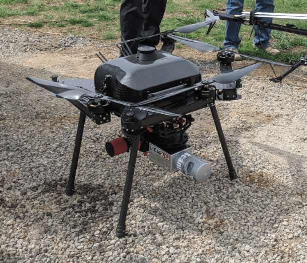
That’s why Harris Aerial, one of the world leaders in developing new drone technology, has partnered with LiDAR USA and Skytec to demonstrate the capabilities of LiDAR sensors on its Carrier H4 Hybrid Drones.  Harris develops heavy lifting drones: carriers used for industrial applications like crop spraying, utility inspections, military and security applications, and others.  By combining LiDAR sensors with the high endurance of the Carrier H4 Hybrid customers get the best of both worlds.

“Traditional LiDAR surveys are extremely pricey – a one-day survey can range more than six figures,” says Ben Harris, president of Harris Aerial. “By using our hybrid drones, we are able to replace the cost of jet fuel and a plane, yet still spend enough time in the air to complete the survey.”

The Carrier H4 Hybrid drone can fly uninterrupted carrying LiDAR equipment for two and a half hours. In addition to the extended flight, the Carrier H4 Hybrid has the largest capacity for carrying payload on the market.

“Both of these elements are essential to completing LiDAR surveys, as the drone must remain in the air for an extended period of time to capture the image,” Harris says. “This is just another of the very practical uses for the hybrid drone market, which is the future of commercial applications of drones.”


Miriam McNabb

Miriam McNabb is the Editor-in-Chief of DRONELIFE and CEO of JobForDrones, a professional drone services marketplace, and a fascinated observer of the emerging drone industry and the regulatory environment for drones. Miriam has penned over 3,000 articles focused on the commercial drone space and is an international speaker and recognized figure in the industry.  Miriam has a degree from the University of Chicago and over 20 years of experience in high tech sales and marketing for new technologies.
For drone industry consulting or writing, Email Miriam.

TWITTER:@spaldingbarker

Subscribe to DroneLife here.

Filed Under: Drone News Feeds, Featured - Surveying, News, Sensors Tagged With: aerial drone, Carrier H4 Hybrid, Commercial Drones, drone LiDAR, drone surveying, Harris Aerial, hybrid drones, industrial drones

Reader Interactions

Trackbacks

  1. Drone Shows! The Drone Technology on Display this Week at the Energy Drone and Robotics Summit - The Drone Page says:
    October 27, 2021 at 1:19 pm

    […] more about the Energy Drones and Robotics Summit, Commaris, Vantis, Harris Aerial, and […]

    Reply
  2. Endurance Flight without a Helicopter: Drone Tech Firm Harris Aerial Demonstrates LiDAR with Carrier H4 Hybrid - King Drones Review | The Drones Kingdom says:
    June 18, 2018 at 3:32 pm

    […] post Endurance Flight without a Helicopter: Drone Tech Firm Harris Aerial Demonstrates LiDAR with Carrier… appeared first on […]

    Reply

Leave a Reply Cancel reply

Your email address will not be published. Required fields are marked *

Primary Sidebar

LATEST

Blue Innovation Deploys Drones for Nighttime Wildfire Imaging in Japan

This article published in collaboration with JUIDA, the Japan UAS Industrial Development Association.     Blue Innovation Co., Ltd. deployed drones…

Continue Reading Blue Innovation Deploys Drones for Nighttime Wildfire Imaging in Japan

University of Kentucky Researcher Wins NSF Award for Drone Fleet Safety Research

A University of Kentucky researcher has received a National Science Foundation (NSF) CAREER Award worth $534,264 over five years to develop safer…

Continue Reading University of Kentucky Researcher Wins NSF Award for Drone Fleet Safety Research

Canada Bets Big on Sovereign Drone Power with New National Innovation Hub

Canada to establish Drone Innovation Hub By DRONELIFE Features Editor Jim Magill Canada, which has become a world leader in…

Continue Reading Canada Bets Big on Sovereign Drone Power with New National Innovation Hub

Drones Support World-First Mouse Eradication Project on Remote Australian Island

Aerial baiting effort aims to restore seabird populations and fragile ecosystems A remote island off the coast of Western Australia…

Continue Reading Drones Support World-First Mouse Eradication Project on Remote Australian Island

Who Gets to Fly? ACLU Paper Examines the Future of Drone Access

Access, Regulation, and the Future of Drone Use Analysis raises questions about how policy decisions may shape who benefits from…

Continue Reading Who Gets to Fly? ACLU Paper Examines the Future of Drone Access

New DJI Avata 360 Brings 8K 360-Degree FPV Flying to Creators

DJI today launched the DJI Avata 360, a new 8K 360-degree FPV drone built for immersive aerial content creation. The…

Continue Reading New DJI Avata 360 Brings 8K 360-Degree FPV Flying to Creators

Michigan Pushes Sweeping Drone Legislation Package Through State Legislature

By Dronelife Features Editor Jim Magill An extensive package of drone-related legislation, ranging from bills that would restrict the use…

Continue Reading Michigan Pushes Sweeping Drone Legislation Package Through State Legislature

AirData Launches 3D Flight Player for Advanced Drone Flight Review

New tool converts flight logs into interactive 3D visualizations for training and analysis AirData has introduced a new tool designed…

Continue Reading AirData Launches 3D Flight Player for Advanced Drone Flight Review

Lucid Bots Raises $20M to Scale Autonomous Exterior Cleaning Drone Platform

Funding supports expansion of robotics, AI, and subscription-based service model for cleaning operators Lucid Bots has raised $20 million in…

Continue Reading Lucid Bots Raises $20M to Scale Autonomous Exterior Cleaning Drone Platform

Drones Transform Warehouse Operations at Southern Glazer’s

Corvus Robotics rollout supports supply chain transformation and improved warehouse performance Southern Glazer’s Wine & Spirits has expanded its use…

Continue Reading Drones Transform Warehouse Operations at Southern Glazer’s

Secondary Sidebar

Footer

SPONSORED

Inspired Flight Gremsy IF800 VIO F1 drones geo week

What Will It Take to Strengthen U.S. Drone Manufacturing? A Conversation with Inspired Flight’s CEO

Global Mapper Mobile data collection

Collection Ground Control Points with Global Mapper Mobile

Military Drone Mapping Solutions

How SimActive’s Correlator3D™ is Revolutionizing Military Mapping: An Exclusive Interview with CEO Philippe Simard

Photogrammetry Accuracy Standards

SimActive Photogrammetry Software: Enabling Users to Meet Accuracy Standards for Over 20 Years

NACT Engineering Parrot ANAFI tether indoor shot

Smart Tether for Parrot ANAFI USA from NACT Engineering

Blue Marble, features global mapper, features Blue Marble

Check Out These New Features in Global Mapper v25 from Blue Marble

About Us | Contact Us | Advertise With Us | Write for Us | Privacy Policy | Terms of Service

The Trusted Source for the Business of Drones.

This website uses cookies and third party services. By clicking OK, you are agreeing to our privacy policy. ACCEPT

Manage consent

Privacy Overview

This website uses cookies to improve your experience while you navigate through the website. Out of these, the cookies that are categorized as necessary are stored on your browser as they are essential for the working of basic functionalities of the website. We also use third-party cookies that help us analyze and understand how you use this website. These cookies will be stored in your browser only with your consent. You also have the option to opt-out of these cookies. But opting out of some of these cookies may affect your browsing experience.
Necessary
Always Enabled
Necessary cookies are absolutely essential for the website to function properly. These cookies ensure basic functionalities and security features of the website, anonymously.
CookieDurationDescription
cookielawinfo-checkbox-analytics11 monthsThis cookie is set by GDPR Cookie Consent plugin. The cookie is used to store the user consent for the cookies in the category "Analytics".
cookielawinfo-checkbox-functional11 monthsThe cookie is set by GDPR cookie consent to record the user consent for the cookies in the category "Functional".
cookielawinfo-checkbox-necessary11 monthsThis cookie is set by GDPR Cookie Consent plugin. The cookies is used to store the user consent for the cookies in the category "Necessary".
cookielawinfo-checkbox-others11 monthsThis cookie is set by GDPR Cookie Consent plugin. The cookie is used to store the user consent for the cookies in the category "Other.
cookielawinfo-checkbox-performance11 monthsThis cookie is set by GDPR Cookie Consent plugin. The cookie is used to store the user consent for the cookies in the category "Performance".
viewed_cookie_policy11 monthsThe cookie is set by the GDPR Cookie Consent plugin and is used to store whether or not user has consented to the use of cookies. It does not store any personal data.
Functional
Functional cookies help to perform certain functionalities like sharing the content of the website on social media platforms, collect feedbacks, and other third-party features.
Performance
Performance cookies are used to understand and analyze the key performance indexes of the website which helps in delivering a better user experience for the visitors.
Analytics
Analytical cookies are used to understand how visitors interact with the website. These cookies help provide information on metrics the number of visitors, bounce rate, traffic source, etc.
Advertisement
Advertisement cookies are used to provide visitors with relevant ads and marketing campaigns. These cookies track visitors across websites and collect information to provide customized ads.
Others
Other uncategorized cookies are those that are being analyzed and have not been classified into a category as yet.
SAVE & ACCEPT