• Skip to main content
  • Skip to secondary menu
  • Skip to primary sidebar
  • Skip to secondary sidebar
  • Skip to footer
  • DroneRacingLife
  • DroneFlyers
  • Newsletter
DroneLife

DRONELIFE

Stay up to date on all the latest Drone News

  • News
  • Products
  • Industries
    • Agriculture
    • Construction
    • Delivery
    • Dual Use
    • Inspection
    • Public Safety
    • Surveying
  • Enthusiasts
  • Regulations
  • Business
  • Video
  • Podcasts

Does DJI’s Geofencing Update Go Far Enough?

July 6, 2016 by Malek Murison 8 Comments

The constant barrage of negative publicity facing the drone industry is more often than not down to two things. The first is the media, which often enjoys taking situations way out of proportion and sensationalizing news to sell papers and drive traffic – how about the plastic bag that ‘collided’ with a plane in London earlier this year? The second reason that the fire of negative publicity continues to burn comes down to the actions of a tiny minority of pilots, who insist on breaching no-fly zones and giving the wider community a bad reputation. Chinese manufacturer DJI has released an update for its ‘Go’ app with improved geofencing, but does it go far enough?

What does the update mean for DJI pilots?

DJI geofencing
DJI can set up new geofencing locations according to local events

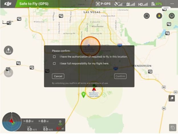
DJI’s Geospatial Environment Online software will help pilots avoid flying drones near airports and other sensitive locations. The app will also automatically updated with temporary flight restrictions around wildfires, to help protect authorized firefighting aircraft and ensure fire crews can operate without disruption.

“Safety is DJI’s top priority, which is why we first introduced geofencing technology three years ago and have been steadily refining the industry’s best technology to enhance aviation safety,” said Brendan Schulman, DJI Vice President of Policy and Legal Affairs, who led the development of the new system. “Drone pilots want to fly safely, and our GEO system helps DJI customers fly responsibly while also enabling the full capabilities of remotely piloted aircraft.”

On the face of it, this is another positive move from a manufacturer with no obligation to enforce safety features. But there is an ‘opt-out’ option, which allows DJI pilots to disable the ban in many, but not all, cases. The Chinese firm has confirmed it will keep a record of those who use the opt-out feature, and that the move will make it easier for authorized personnel to carry out inspections and other sanctioned activities areas that are normally off-limits.

What’s the point in having an ‘opt-out’ option?

Pilots can opt out of many of DJI's geofences
Pilots can opt out of many of DJI’s geofences

Understandably, DJI is reluctant to enforce widespread geofencing when many commercial pilots may be using its drones for official work in no-fly zones. But, with the industry already facing plenty of public skepticism and relatively strict regulations, is there an element of hypocrisy here? Is it justified to complain about regulations and negative press when there arguably isn’t enough self-regulation? If manufacturers such as DJI have the ability to implement non-optional geofencing, isn’t it in their interest to?

Should manufacturers even be responsible for implementing no-fly zones?

Probably not, no. Enforcing no-fly zone restrictions through geofencing is something that regulatory bodies, in partnership with manufacturers, should take control of. That DJI is doing something to appease regulatory bodies should be commended. But whichever way you look at it, shouldn’t geofencing be an all or nothing application? Either you outright prevent drones from flying where they could be dangerous, or you allow pilots free reign. Having said that, as long as only certain manufacturers include geofencing software, anyone seeking to ‘go rogue’ isn’t going to have any great difficulty doing so.

What does DJI think?

In an interview with the BBC, DJI’s legal affairs chief, Brendan Schulman, reinforced the notion that it’s the drone operator that’s responsible and accountable for their actions. “Just like driving a car, it is up to the operator to be licensed, to have the car registered and insured – the manufacturer of an automobile doesn’t decide who gets to drive or not. Similarly, we have provided a mechanism for operators to take responsibility and verify their accounts and then go ahead and fly in most of these locations.”

The company sees pilots’ ability to simply turn off the geofencing as a balance between safety and innovation. But, as Shulman admitted, “We don’t have the ability to verify if someone has authorization [to fly in a restricted area]”.

Shulman also pointed out that, to make use of the geofencing override, a user must have given DJI their credit card details or a mobile number to act as an ID. This should allow the Chinese firm to help authorities track down rogue pilots. But how accessible will this information be if the authorities do come calling? “Our policy is to provide information about our customers only in response to a valid legal request,” Mr Schulman said. “So, in the US it would be a subpoena or a warrant or a court order.”

Send us your thoughts on geofencing

Do you fly with DJI, or another manufacturer that includes built-in geofencing? Do you think it’s already restricting the freedom of pilots, or does it not go far enough? Let us know and we’ll put together  another piece based on your thoughts.

Malek Murison
Malek Murison

Malek Murison is a freelance writer and editor with a passion for tech trends and innovation. He handles product reviews, major releases and keeps an eye on the enthusiast market for DroneLife.
Email Malek
Twitter:@malekmurison

Subscribe to DroneLife here.

Filed Under: Commentary, Enthusiasts, Featured - Enthusiasts, News, News Reports, Technology Tagged With: BBC, Brendan Schulman, DJI, geofencing, GO

Reader Interactions

Comments

  1. Weitling says

    July 14, 2016 at 7:25 pm

    There will always be people that not respect airport, privacy, public places…. I believe this can cause even stronger regulations that have a negative impact on this hobby. Somehow geofencing is good to at least protect this hobby.

    Reply
  2. David says

    July 14, 2016 at 3:39 pm

    Geofencing will hurt the industry companies who want to use Drones for business should be able to make the decision on where they can fly. And if its a restricted area they pay the price. The issues I see coming is that the Geofencing will make the drone hackers start hacking into the system and removing it. That will be a bigger issue. We all have a choice don’t speed you will get a ticket so the law is there break it pay a fine. Enough said.

    Reply
  3. Alan says

    July 7, 2016 at 1:09 am

    I will not purchase a product with geo fencing. DJI is cutting their own throat, getting too complicated, and they keep adding MORE NFZ’s.

    Reply
    • Mark Williams says

      July 7, 2016 at 7:38 am

      It’s only a matter of time before 3DR, Yuneec, and most Drone mfg’s that have GPS enabled Flight Controller follow suit.. It’s that or possibly even more federal or local regulations.. There will always be open source FC’s available without geo fencing.. Unless they become Illegal to own..

      Reply
      • David says

        July 14, 2016 at 3:41 pm

        I agree fully. Open source FC sells will jump 100%

        Reply

Trackbacks

  1. Media Coverage in the Drone Industry: Perspective Needed - Drone Flights R Us says:
    July 11, 2017 at 12:50 am

    […] easy to see where Schulman is coming from here. With measures in place including geofencing around prisons and airports, it’s safe to say that DJI is doing what it can to stop rogue […]

    Reply
  2. DJI GeoFences Parts of Iraq and Syria After Isis Attacks - Drone Flights R Us says:
    April 27, 2017 at 10:33 pm

    […] Read more: Does DJI Geofencing Update Go Far Enough? […]

    Reply
  3. Does DJI’s Geofencing Update go far Enough? | ohioaviators.com says:
    July 7, 2016 at 6:05 am

    […] post Does DJI’s Geofencing Update go far Enough? appeared first on […]

    Reply

Leave a Reply Cancel reply

Your email address will not be published. Required fields are marked *

Primary Sidebar

LATEST

Aeronext Unveils ActiveWing Logistics Drone Prototype for Long-Range Delivery

This article published in collaboration with JUIDA, the Japan UAS Industrial Development Association.     The Tokyo company’s new multicopter pairs…

Continue Reading Aeronext Unveils ActiveWing Logistics Drone Prototype for Long-Range Delivery

FBI, Atlanta PD Stress Need for ‘No-Drone Zone’ Compliance

By Dronelife Features Editor Jim Magill (Editor’s note: This story is part of a series of reports on efforts to…

Continue Reading FBI, Atlanta PD Stress Need for ‘No-Drone Zone’ Compliance

Building a Resilient Supply Chain: Regional Security Leaders Focus on Industrial Readiness

Northeast National Security Conference examines how the U.S. can strengthen its defense industrial base Supply chain security has become a…

Continue Reading Building a Resilient Supply Chain: Regional Security Leaders Focus on Industrial Readiness

Defense Leaders Call for Faster Paths from Innovation to the Field

Remarks at the Northeast National Security Conference highlight growing demand for rapid, commercially informed defense solutions The 2026 Northeast National…

Continue Reading Defense Leaders Call for Faster Paths from Innovation to the Field

Collective Defence Acquires Asterion in $1 Billion Deal Combining Cybersecurity and Counter-Drone Technology

Transaction creates Luxembourg’s first defense unicorn and brings together cyber defense and combat-tested counter-UAS capabilitie Collective Defence has announced its…

Continue Reading Collective Defence Acquires Asterion in $1 Billion Deal Combining Cybersecurity and Counter-Drone Technology

Vantis BVLOS System Adds New Partner, FAA Waiver Across 5,000 Square Miles

A new FAA aircraft-agnostic waiver lets Frontier Precision fly any NDAA-compliant drone under 55 pounds across more than 5,000 square…

Continue Reading Vantis BVLOS System Adds New Partner, FAA Waiver Across 5,000 Square Miles

MatrixSpace Validated in U.S. Army’s Operation Jailbreak Integration Sprint

The portable radar maker’s integration with Anduril Lattice and IBCS-M passed Army validation at Fort Carson, joining 55 companies in…

Continue Reading MatrixSpace Validated in U.S. Army’s Operation Jailbreak Integration Sprint

Army Medical Brigade Expands Drone Use for Battlefield Resupply

New training program helps medical personnel deliver critical supplies faster while reducing risk to soldiers The U.S. Army’s 44th Medical…

Continue Reading Army Medical Brigade Expands Drone Use for Battlefield Resupply

Counter-Drone Partnership Sends Ouster Shares Higher as Investors Focus on Airspace Security

Lidar company’s agreement with German counter-UAS firm highlights growing market for drone detection and interception technologies Shares of lidar manufacturer…

Continue Reading Counter-Drone Partnership Sends Ouster Shares Higher as Investors Focus on Airspace Security

Airport Drone Closures Raise a Bigger Question: What Do Authorities Actually Know?

Recent airport disruptions highlight a growing challenge: detecting an object in protected airspace is often easier than identifying it, locating…

Continue Reading Airport Drone Closures Raise a Bigger Question: What Do Authorities Actually Know?

Secondary Sidebar

Footer

SPONSORED

Inspired Flight Gremsy IF800 VIO F1 drones geo week

What Will It Take to Strengthen U.S. Drone Manufacturing? A Conversation with Inspired Flight’s CEO

Global Mapper Mobile data collection

Collection Ground Control Points with Global Mapper Mobile

Military Drone Mapping Solutions

How SimActive’s Correlator3D™ is Revolutionizing Military Mapping: An Exclusive Interview with CEO Philippe Simard

Photogrammetry Accuracy Standards

SimActive Photogrammetry Software: Enabling Users to Meet Accuracy Standards for Over 20 Years

NACT Engineering Parrot ANAFI tether indoor shot

Smart Tether for Parrot ANAFI USA from NACT Engineering

Blue Marble, features global mapper, features Blue Marble

Check Out These New Features in Global Mapper v25 from Blue Marble

About Us | Contact Us | Advertise With Us | Write for Us | Privacy Policy | Terms of Service

The Trusted Source for the Business of Drones.

This website uses cookies and third party services. By clicking OK, you are agreeing to our privacy policy. ACCEPT

Manage consent

Privacy Overview

This website uses cookies to improve your experience while you navigate through the website. Out of these, the cookies that are categorized as necessary are stored on your browser as they are essential for the working of basic functionalities of the website. We also use third-party cookies that help us analyze and understand how you use this website. These cookies will be stored in your browser only with your consent. You also have the option to opt-out of these cookies. But opting out of some of these cookies may affect your browsing experience.
Necessary
Always Enabled
Necessary cookies are absolutely essential for the website to function properly. These cookies ensure basic functionalities and security features of the website, anonymously.
CookieDurationDescription
cookielawinfo-checkbox-analytics11 monthsThis cookie is set by GDPR Cookie Consent plugin. The cookie is used to store the user consent for the cookies in the category "Analytics".
cookielawinfo-checkbox-functional11 monthsThe cookie is set by GDPR cookie consent to record the user consent for the cookies in the category "Functional".
cookielawinfo-checkbox-necessary11 monthsThis cookie is set by GDPR Cookie Consent plugin. The cookies is used to store the user consent for the cookies in the category "Necessary".
cookielawinfo-checkbox-others11 monthsThis cookie is set by GDPR Cookie Consent plugin. The cookie is used to store the user consent for the cookies in the category "Other.
cookielawinfo-checkbox-performance11 monthsThis cookie is set by GDPR Cookie Consent plugin. The cookie is used to store the user consent for the cookies in the category "Performance".
viewed_cookie_policy11 monthsThe cookie is set by the GDPR Cookie Consent plugin and is used to store whether or not user has consented to the use of cookies. It does not store any personal data.
Functional
Functional cookies help to perform certain functionalities like sharing the content of the website on social media platforms, collect feedbacks, and other third-party features.
Performance
Performance cookies are used to understand and analyze the key performance indexes of the website which helps in delivering a better user experience for the visitors.
Analytics
Analytical cookies are used to understand how visitors interact with the website. These cookies help provide information on metrics the number of visitors, bounce rate, traffic source, etc.
Advertisement
Advertisement cookies are used to provide visitors with relevant ads and marketing campaigns. These cookies track visitors across websites and collect information to provide customized ads.
Others
Other uncategorized cookies are those that are being analyzed and have not been classified into a category as yet.
SAVE & ACCEPT