

• Skip to main content
  • Skip to secondary menu
  • Skip to primary sidebar
  • Skip to secondary sidebar
  • Skip to footer
  • DroneRacingLife
  • DroneFlyers
  • Newsletter
DroneLife

DRONELIFE

Stay up to date on all the latest Drone News

  • News
  • Products
  • Industries
    • Agriculture
    • Construction
    • Delivery
    • Dual Use
    • Inspection
    • Public Safety
    • Surveying
  • Enthusiasts
  • Regulations
  • Business
  • Video
  • Podcasts

Who Owns the Sky Part II: The FAA’s Drone Integration Plan, Reloaded

April 29, 2014 by Alan Phillips 1 Comment

faaThis post is Part Two of Who Owns the Sky? and will address the major goals and timeline of the FAA’s Integration of Civil Unmanned Aircraft Systems (UAS) in the National Airspace System (NAS) Roadmap. For Part One, which is an examination of the problems created by the integration of UAS, go here.

There is a lot to cover here so I’m just going to jump in. The one thing to keep in mind is the FAA is a government organization and all the dates provided are target dates. So to accurately set your expectations, add about six months onto any given date….if the date in question happens to fall during an election year, its probably safe to add 6 more.

Certification- The FAA believes that both drones and ‘pilots’ should be certified before they are cleared for take off. UAS themselves will need to pass an inspection that deems them “airworthy” and pilots will be licensed just like any airplane pilot or automobile driver. As such, the FAA has laid out the following benchmarks:

    • Certification process established for one or more civil applicants by 2014. [Completed]
    • Initial issue papers for one or more standard airworthiness certification projects available by 2014.
    • FAA unique certification requirements published by 2015 and test projects completed by 2017.
    • Certification for pilots and crew for sUAS classes published by 2014 (in accordance with and defined by the FAA Modernization and Reform Act of 2012)
    • Certification requirements for pilots and crew not listed in the FMRA published by 2014-2017

Translation: Sometime between now and 2017(ish) the FAA wants to develop two set of criteria. One that outlines the hardware requirements for a commercial drone and one that establishes the “pilot’s test” for obtaining a license to fly said drone. And the licenses will be first available to those defined in the FMRA as part of an sUAS class (ie those already part of the aerospace industry). Fun Fact: The FAA does preface this goal by saying “not all UAS operations conducted for hire and compensation will require an Operator Certificate,” but mum is the word on what sort of operations these might be. It seems that the FAA reserves the right to tell you to get a pilots license ‘because we said so.’

Sense and Avoid- There are two sense and avoid methods recognized by the FAA. The first is a Ground Based Sense and Avoid (GBSAA) system, which is just a fancy way of saying “the way by which a human being, who is constantly monitoring the drone, can tell a UAS not to hit something.” The second, is a Airborne Sense and Avoid (ABSAA) system which takes the human out of the equation and just includes the “on board” sense and avoid software. And they both need to be regulated, separately:

GBSAA:

    • Advisory Circular on GBSAA systems and requirements released by 2015
    • FAA approvals for use of GBSAA for educational and other public applications granted 2016-2018. Operation of the UAS is still subject to the approval of COA.

ABSAA

    • Initial certification of ABSAA that facilitates UAS operations without the requirements of visual observer by 2016-2020.
    • The first ABSAA certifications will be developed to be used by the Department of Defense “and other public and civil entities” in the National Airspace classes A, D, E and G.

Translation: It is going to take 4+ years for the FAA to essentially update the current system of air traffic control to include UAS and 6+ years to begin testing large-scale autonomous flight. Fun Fact: At best, by the time the GBSAA regulations are in place, they will be short lived. The point of drones is they are an autonomous aerial solution. By definition, a vehicle can’t be autonomous if it is susceptible to crashing into things. The self-location and environmental mapping/detection software that is being developed today will make the drones (and, incidentally, cars) of tomorrow far more qualified to pilot themselves than any human. The focus of the FAA when it comes to sense and avoid should be the Airborne systems. By studying the autonomous piloting of unmanned vehicles now, there will be precedents in place when the self-driving car comes to market.

Control and Communications- (where line of sight refers to radio signals not eyeballs)- Similar to above, the FAA wants to regulate the way by which people talk to drones once they are flying:

    • Initial regulation and guidance material to enable production, sale, installation, and Maintenance of FAA-certified systems and services using line-of-sight (LOS) published by 2016-2017.
    • International agreements, industry standards, FAA regulations and guidance material for beyond-line-of sight (BLOS) established by 2015 for civil UAS Control and Communications capabilities so they can be certified by FAA for FAA-approved operations.

Translation: The sale of LOS drone will not be sanctioned by FAA until 2017 at the earliest and the FAA sees the need to establish a globally agreed upon radio spectrum for UAS communication.

Small UAS- These are the benchmarks for the regulation of small unmanned aircraft systems, or drones that weigh less than 55 lbs.

    • Finalize and sign memorandums of agreement signed in conjunction with the release of Notice of Proposed Rulemaking. This was slated for early 2014, and has since been pushed back to November.
    • Train air traffic control workforce to work with sUAS six months after rule enactment; ongoing training through 2020.
    • Final Rule published to implement the recommendations of the plan required by the FMRA by end of 2015.

Translation: This is the part of the document that has lead to everyone saying 2015 is the magic year when commercial drones will be legal in the U.S.Screen-Shot-2014-03-06-at-6.30.30-PM1
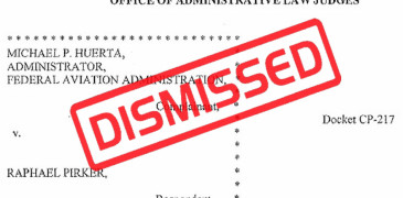
Fun Fact: There is no way the FAA is going to hit that deadline. Additionally, it may come to pass that the FAA has no legal jurisdiction over this class of drones, as a judge recently dismissed a case in which the FAA levied a $10,000 fine against a Virginia man for recklessly flying his drone.

Whew. That is a lot of information. I will let that sink in and promise to be more succinct in the forthcoming final installment of Who Owns the Sky where I will look at what all this means if you want to go launch a drone business tomorrow.

<<<  Read Part I                                                                                                                                 Read Part III  >>>

Alan Phillips
Alan Phillips

Alan is serial entrepreneur, active angel investor, and a drone enthusiast. He co-founded DRONELIFE.com to address the emerging commercial market for drones and drone technology. Prior to DRONELIFE.com, Alan co-founded Where.com, ThinkingScreen Media, and Nurse.com. Recently, Alan has co-founded Crowditz.com,  a leader in Equity Crowdfunding Data, Analytics, and Insights.  Alan can be reached at alan(at)dronelife.com

Filed Under: Legal, News Tagged With: Department of Defense, Drone Law, FAA, FAA Roadmap, FMRA, sUAS, Who Owns the Sky

Reader Interactions

Comments

  1. Hiroyuki says

    September 17, 2015 at 7:10 am

    and the Anarcho-Tyranny of the Left and the Elites continues unetabad. they stomp on Citizens, while letting Illegal Invaders roam free committing murders, rapes, driving drunk, killing our sons and daughters while they try to go to school or work. we Citizens need to shove this sickening Anarcho-Tyranny down their F’g throats, this November 2012.

    Reply

Leave a Reply Cancel reply

Your email address will not be published. Required fields are marked *

Primary Sidebar

LATEST

AVI-SPL and Matternet Partner on Drone Delivery for Field Technicians

The partnership pairs Matternet’s FAA type-certified drone platform with AVI-SPL’s service network to move replacement parts to technicians in congested…

Continue Reading AVI-SPL and Matternet Partner on Drone Delivery for Field Technicians

City of Raleigh Uses Drones, AI Technology to Create Digital Twin

The city of Raleigh, North Carolina is deploying drones and artificial-intelligence (AI)-enabled tools to create a virtual version of itself…

Continue Reading City of Raleigh Uses Drones, AI Technology to Create Digital Twin

Northern Plains UAS Test Site Flies Medical and Agricultural BVLOS Demos on Vantis at NASAO

State aviation officials watched live flights at Gorman Field as CVS Health, Kelly Hills Unmanned, SkyfireAI and Thales demonstrated medical…

Continue Reading Northern Plains UAS Test Site Flies Medical and Agricultural BVLOS Demos on Vantis at NASAO

SkyDrive and Verty Target Commercial eVTOL Operations in South Korea by 2028

Partnership will study tourism and regional transportation routes for the three-seat SKYDRIVE aircraft Japanese eVTOL developer SkyDrive has partnered with…

Continue Reading SkyDrive and Verty Target Commercial eVTOL Operations in South Korea by 2028

SkyeBrowse Moves to Per-Model Pricing, Lowering the Barrier to 3D Drone Mapping

New Commercial, Pro and Public Safety & Enterprise plans offer different levels of processing, storage and tools based on each…

Continue Reading SkyeBrowse Moves to Per-Model Pricing, Lowering the Barrier to 3D Drone Mapping

From Maps to Operational Intelligence: How Defense Is Changing the Mapping Workflow

From the INTERGEO show floor in Munich, SimActive CEO Philippe Simard discusses why speed, usability and data integration increasingly matter…

Continue Reading From Maps to Operational Intelligence: How Defense Is Changing the Mapping Workflow

Flytrex Adds Rooftop Drone Docks and AI Fleet Positioning in Dallas

The company says prepositioning drones at restaurants can cut delivery costs by 60% and reduce delivery times by half. Flytrex…

Continue Reading Flytrex Adds Rooftop Drone Docks and AI Fleet Positioning in Dallas

From Wildfire Detection to Fast Mapping: AIVE AI Systems Expands Access to Geospatial Data

The startup is developing tools that create georeferenced 2D maps from a small number of images, without requiring specialized infrastructure.…

Continue Reading From Wildfire Detection to Fast Mapping: AIVE AI Systems Expands Access to Geospatial Data

FirstEnergy Grant Expands Drone Training for Educators and Police

WarrenUAS will use the funding to provide FAA Part 107 preparation and hands-on flight training in New Jersey. A FirstEnergy…

Continue Reading FirstEnergy Grant Expands Drone Training for Educators and Police

Airwise Solutions and UAS Sentry Integrate Drone Detection and Airspace Intelligence

Partnership brings Remote ID detection into a common operating picture for critical infrastructure, public safety and enterprise users. Airwise Solutions…

Continue Reading Airwise Solutions and UAS Sentry Integrate Drone Detection and Airspace Intelligence

Secondary Sidebar

Footer

SPONSORED

What Is the Best Commercial Cleaning Drone in 2026? Specs, Prices, and a Head-to-Head Comparison

Inspired Flight Gremsy IF800 VIO F1 drones geo week

What Will It Take to Strengthen U.S. Drone Manufacturing? A Conversation with Inspired Flight’s CEO

Global Mapper Mobile data collection

Collection Ground Control Points with Global Mapper Mobile

Military Drone Mapping Solutions

How SimActive’s Correlator3D™ is Revolutionizing Military Mapping: An Exclusive Interview with CEO Philippe Simard

Photogrammetry Accuracy Standards

SimActive Photogrammetry Software: Enabling Users to Meet Accuracy Standards for Over 20 Years

NACT Engineering Parrot ANAFI tether indoor shot

Smart Tether for Parrot ANAFI USA from NACT Engineering

About Us | Contact Us | Advertise With Us | Write for Us | Privacy Policy | Terms of Service

The Trusted Source for the Business of Drones.

This website uses cookies and third party services. By clicking OK, you are agreeing to our privacy policy. ACCEPT

Manage consent

Privacy Overview

This website uses cookies to improve your experience while you navigate through the website. Out of these, the cookies that are categorized as necessary are stored on your browser as they are essential for the working of basic functionalities of the website. We also use third-party cookies that help us analyze and understand how you use this website. These cookies will be stored in your browser only with your consent. You also have the option to opt-out of these cookies. But opting out of some of these cookies may affect your browsing experience.
Necessary
Always Enabled
Necessary cookies are absolutely essential for the website to function properly. These cookies ensure basic functionalities and security features of the website, anonymously.
CookieDurationDescription
cookielawinfo-checkbox-analytics11 monthsThis cookie is set by GDPR Cookie Consent plugin. The cookie is used to store the user consent for the cookies in the category "Analytics".
cookielawinfo-checkbox-functional11 monthsThe cookie is set by GDPR cookie consent to record the user consent for the cookies in the category "Functional".
cookielawinfo-checkbox-necessary11 monthsThis cookie is set by GDPR Cookie Consent plugin. The cookies is used to store the user consent for the cookies in the category "Necessary".
cookielawinfo-checkbox-others11 monthsThis cookie is set by GDPR Cookie Consent plugin. The cookie is used to store the user consent for the cookies in the category "Other.
cookielawinfo-checkbox-performance11 monthsThis cookie is set by GDPR Cookie Consent plugin. The cookie is used to store the user consent for the cookies in the category "Performance".
viewed_cookie_policy11 monthsThe cookie is set by the GDPR Cookie Consent plugin and is used to store whether or not user has consented to the use of cookies. It does not store any personal data.
Functional
Functional cookies help to perform certain functionalities like sharing the content of the website on social media platforms, collect feedbacks, and other third-party features.
Performance
Performance cookies are used to understand and analyze the key performance indexes of the website which helps in delivering a better user experience for the visitors.
Analytics
Analytical cookies are used to understand how visitors interact with the website. These cookies help provide information on metrics the number of visitors, bounce rate, traffic source, etc.
Advertisement
Advertisement cookies are used to provide visitors with relevant ads and marketing campaigns. These cookies track visitors across websites and collect information to provide customized ads.
Others
Other uncategorized cookies are those that are being analyzed and have not been classified into a category as yet.
SAVE & ACCEPT




