
• Skip to main content
  • Skip to secondary menu
  • Skip to primary sidebar
  • Skip to secondary sidebar
  • Skip to footer
  • DroneRacingLife
  • DroneFlyers
  • Newsletter
DroneLife

DRONELIFE

Stay up to date on all the latest Drone News

  • News
  • Products
  • Industries
    • Agriculture
    • Construction
    • Delivery
    • Dual Use
    • Inspection
    • Public Safety
    • Surveying
  • Enthusiasts
  • Regulations
  • Business
  • Video
  • Podcasts

DJI Launches Products for Commercial Pilots at CES 2017

January 4, 2017 by Malek Murison Leave a Comment

Forget Christmas. For tech fans and keen watchers of the drone industry, the Consumer Electronics Show represents the real festive season. CES 2017 is here, and we’re expecting plenty of product and partnership announcements from both the biggest and smallest names in the industry. Today we’ve had news from DJI. To continue its domination of the drone market, it’s launching a charm offensive on commercial pilots.

First up we’ve got DJI’s new Ground Station Pro App. Second is the launch of the CrystalSky Display. Both are targeted at professional operators.

The Chinese manufacturer displayed two variations of its CrystalSky prototype, an ultra-bright monitor developed specifically for outdoor aerial imaging operators.


Ground Station Pro

dji GS pro app

Ground Station Pro, also known as GS Pro, is an iPad app that DJI has put together to allow professional pilots to plan and execute autonomous flights. Through the app’s concise, easy to use interface, complex flight missions can be planned with just a few taps. GS Pro was designed to help out commercial pilots in a wide range of industries, from aerial mapping, architecture, precision agriculture and electrical inspections.

The 3D Map Area function allows the aircraft to generate efficient flight paths after the operator has set their required flight zone and camera parameters. The aircraft will then follow this route throughout its mission. The image data captured during these flights can be input into 3D reconstruction software to generate 3D maps, while the mission itself can be saved for re-use.
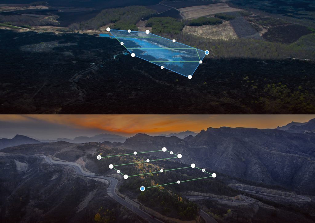
The app also comes with a Tap and Go Waypoint feature, which allows pilots to pre-program up to 99 waypoints in every mission, while each waypoint can have up to 15 consecutive actions. These actions include aircraft rotation, gimbal pitch, start/stop recording, photo capture, and hover. A Virtual Fence increases safety and ease of use by locking the aircraft’s height and speed within a designated area. As the aircraft approaches the virtual fence, it will brake and hover to ensure it stays within the flight area.

“DJI has developed some of the world’s best aerial platforms and camera technology and now, we bring to our customers a new range of product extensions and accessories to further expand their creative possibilities. Whether it’s giving professional operators more control and flexibility with the CrystalSky monitor, or having an easy-to-use application for an aerial mapping project, we want to empower creators with the tools they need to bring their ideas to life.” – Paul Pan, DJI’s lead engineer.

DJI says that “GS Pro will serve as a powerful and convenient tool for many industries and give critical missions added accuracy and reliability.”

The GS Pro iPad app is free and available for download at the App Store.

The CrystalSky Monitor

one prototype of dki's crystalsky monitor

DJI has also announced plans for a new monitor to fulfil the needs of commercial pilots. CrystalSky has been launched specifically for outdoor aerial imaging and features an ultra-bright screen that’s easily visible in sunlight. It works seamlessly with the DJI GO app to give camera operators total control.

A maximum 2000 cd/m2 of brightness means the CrystalSky monitor is more than four times as bright as typical mobile devices. The idea is that the screen’s capability is sharp enough to allow pilots to fine-tune image composition during flight. The monitor supports H.264 and H.265 video decoding, allowing it to play back files at up to 30 fps and 60 fps respectively.

The CrystalSky monitor’s HDMI port allows 4K video to be output to FPV goggles and other display devices. Storage can be extended and a Micro SD Card can be played back directly on the monitor. It can also be used for footage backups. The DJI App comes built in.

DJI has said that the CrystalSky monitor will come in two sizes: 7.85″ and 5.5″ screens, which are expected to achieve a maximum operation time of 4-5 hours and 5-6 hours respectively. The Chinese drone giant will shortly be giving out more information on pricing and availability of the CrystalSky monitor.

Malek Murison
Malek Murison

Malek Murison is a freelance writer and editor with a passion for tech trends and innovation. He handles product reviews, major releases and keeps an eye on the enthusiast market for DroneLife.
Email Malek
Twitter:@malekmurison

Subscribe to DroneLife here.

Filed Under: Business and Finance, Enthusiasts, Industries, News, Products, Surveying

Reader Interactions

Leave a Reply Cancel reply

Your email address will not be published. Required fields are marked *

Primary Sidebar

LATEST

Cat-Inspired Claws Help Ice Dart Drone Land on Steep Ice

Université de Sherbrooke researchers demonstrate a new approach to landing multirotors on steep, irregular ice surfaces Cats may seem an…

Continue Reading Cat-Inspired Claws Help Ice Dart Drone Land on Steep Ice

Motorola Solutions Completes $1.5 Billion Acquisition of D-Fend Solutions

Counter-drone technology joins Motorola Solutions’ public safety portfolio as demand for airspace protection grows Motorola Solutions has completed its $1.5…

Continue Reading Motorola Solutions Completes $1.5 Billion Acquisition of D-Fend Solutions

Ondas Opens UAS Training and Operations Hub at Ohio’s NAAMCE

New Springfield facility will support long-endurance UAS training, testing and flight operations as Ondas expands its U.S. defense business Ondas…

Continue Reading Ondas Opens UAS Training and Operations Hub at Ohio’s NAAMCE

The White House Wants Drone Dominance. How Much of the Supply Chain Must Be American?

Recent executive orders, FCC action and a White House industry meeting point to growing scrutiny of what goes into U.S.-made…

Continue Reading The White House Wants Drone Dominance. How Much of the Supply Chain Must Be American?

FCC Proposal Could Bring Drone Software and Supply Chains Under Greater Scrutiny

Active FCC rulemaking considers hardware and software disclosures that could affect agricultural and commercial drone manufacturers A new FCC rulemaking…

Continue Reading FCC Proposal Could Bring Drone Software and Supply Chains Under Greater Scrutiny

United Utilities Uses Thermal Drones to Find Hidden Moorland Fire Hotspots

Thermal imaging drones help crews locate underground heat pockets that could reignite after major fires in northwest England. United Utilities…

Continue Reading United Utilities Uses Thermal Drones to Find Hidden Moorland Fire Hotspots

Inside the Counter-UAS Response to Drone Flights Over Spokane Wildfires

FBI and local officials describe how a multi-agency task force detected dozens of unauthorized drones, located pilots and worked to…

Continue Reading Inside the Counter-UAS Response to Drone Flights Over Spokane Wildfires

Saildrone Announces European Expansion With Copenhagen HQ and Three Build Contracts

The maritime autonomy company adds three European build partners and opens Northern Europe operations at the historic Quintus Bastion in…

Continue Reading Saildrone Announces European Expansion With Copenhagen HQ and Three Build Contracts

HOVERAir Launches VERSA 2-in-1 Gimbal and Camera Drone

The 2-in-1 device from ZeroZero Robotics records 4K 60fps video and converts from a pocket gimbal camera into a self-flying…

Continue Reading HOVERAir Launches VERSA 2-in-1 Gimbal and Camera Drone

uAvionix FlightLine Surveillance Data Feeds Airwise Nexus at Skyway Range in Tulsa

The partnership feeds low-altitude cooperative aircraft data from uAvionix’s FlightStation network into the Airwise Nexus platform for Skyway Range BVLOS…

Continue Reading uAvionix FlightLine Surveillance Data Feeds Airwise Nexus at Skyway Range in Tulsa

Secondary Sidebar

Footer

SPONSORED

What Is the Best Commercial Cleaning Drone in 2026? Specs, Prices, and a Head-to-Head Comparison

Inspired Flight Gremsy IF800 VIO F1 drones geo week

What Will It Take to Strengthen U.S. Drone Manufacturing? A Conversation with Inspired Flight’s CEO

Global Mapper Mobile data collection

Collection Ground Control Points with Global Mapper Mobile

Military Drone Mapping Solutions

How SimActive’s Correlator3D™ is Revolutionizing Military Mapping: An Exclusive Interview with CEO Philippe Simard

Photogrammetry Accuracy Standards

SimActive Photogrammetry Software: Enabling Users to Meet Accuracy Standards for Over 20 Years

NACT Engineering Parrot ANAFI tether indoor shot

Smart Tether for Parrot ANAFI USA from NACT Engineering

About Us | Contact Us | Advertise With Us | Write for Us | Privacy Policy | Terms of Service

The Trusted Source for the Business of Drones.

This website uses cookies and third party services. By clicking OK, you are agreeing to our privacy policy. ACCEPT

Manage consent

Privacy Overview

This website uses cookies to improve your experience while you navigate through the website. Out of these, the cookies that are categorized as necessary are stored on your browser as they are essential for the working of basic functionalities of the website. We also use third-party cookies that help us analyze and understand how you use this website. These cookies will be stored in your browser only with your consent. You also have the option to opt-out of these cookies. But opting out of some of these cookies may affect your browsing experience.
Necessary
Always Enabled
Necessary cookies are absolutely essential for the website to function properly. These cookies ensure basic functionalities and security features of the website, anonymously.
CookieDurationDescription
cookielawinfo-checkbox-analytics11 monthsThis cookie is set by GDPR Cookie Consent plugin. The cookie is used to store the user consent for the cookies in the category "Analytics".
cookielawinfo-checkbox-functional11 monthsThe cookie is set by GDPR cookie consent to record the user consent for the cookies in the category "Functional".
cookielawinfo-checkbox-necessary11 monthsThis cookie is set by GDPR Cookie Consent plugin. The cookies is used to store the user consent for the cookies in the category "Necessary".
cookielawinfo-checkbox-others11 monthsThis cookie is set by GDPR Cookie Consent plugin. The cookie is used to store the user consent for the cookies in the category "Other.
cookielawinfo-checkbox-performance11 monthsThis cookie is set by GDPR Cookie Consent plugin. The cookie is used to store the user consent for the cookies in the category "Performance".
viewed_cookie_policy11 monthsThe cookie is set by the GDPR Cookie Consent plugin and is used to store whether or not user has consented to the use of cookies. It does not store any personal data.
Functional
Functional cookies help to perform certain functionalities like sharing the content of the website on social media platforms, collect feedbacks, and other third-party features.
Performance
Performance cookies are used to understand and analyze the key performance indexes of the website which helps in delivering a better user experience for the visitors.
Analytics
Analytical cookies are used to understand how visitors interact with the website. These cookies help provide information on metrics the number of visitors, bounce rate, traffic source, etc.
Advertisement
Advertisement cookies are used to provide visitors with relevant ads and marketing campaigns. These cookies track visitors across websites and collect information to provide customized ads.
Others
Other uncategorized cookies are those that are being analyzed and have not been classified into a category as yet.
SAVE & ACCEPT




