
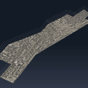
Correlator3D and Phase One Cameras Support Large-Scale Mapping Operations SimActive Inc.’s Correlator3D software is being used by Air Data Solutions (ADS) to map large oil and gas operations in South Texas. By integrating Phase One camera systems, ADS captures thousands of high-resolution images annually to produce detailed digital maps. Streamlining Aerial Mapping with … [Read more...] about SimActive and Air Data Solutions Enhance Oil & Gas Mapping with High-Resolution Aerial Imagery
SimActive
SimActive’s Correlator3D™ 10.3: Revolutionizing Large-Scale Mapping with Enhanced Speed and Flexibility
The latest update tackles big data challenges with optimized workflows and multi-platform integration, delivering powerful solutions for commercial and military applications. by DRONELIFE Staff Writer Ian J. McNabb Quebec-based software developer SimActive Inc. recently announced the release of the new Correlator3D™ Version 10.3, updating their popular mapping solution to … [Read more...] about SimActive’s Correlator3D™ 10.3: Revolutionizing Large-Scale Mapping with Enhanced Speed and Flexibility
Mastering Drone Mapping: Expert Tips for Success from SimActive’s Eric Andelin
SimActive and Correlator3D™: A Closer Look Drone mapping has transformed industries by making geospatial data more accessible. However, achieving high-quality results requires both the right tools and the right approach. DRONELIFE.com interviewed Eric Andelin, Senior Workflow Specialist at SimActive, to uncover actionable tips for drone operators. SimActive, a leader in … [Read more...] about Mastering Drone Mapping: Expert Tips for Success from SimActive’s Eric Andelin
SimActive’s Correlator3D Used for Mapping in New Zealand’s Challenging Terrain
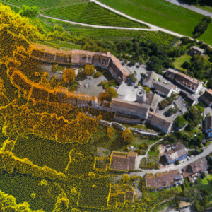
Drone-based imagery processed for agriculture, environmental assessment, and engineering SimActive Inc.'s Correlator3D™ software is being used by GMAPSNZ to produce high-quality mapping products in New Zealand. GMAPSNZ has been using the software to handle New Zealand’s complex terrain, working in agriculture, environmental assessment, and engineering design. For over a … [Read more...] about SimActive’s Correlator3D Used for Mapping in New Zealand’s Challenging Terrain
SimActive Releases Correlator3D Version 10.2 With Enhanced Editing Tools
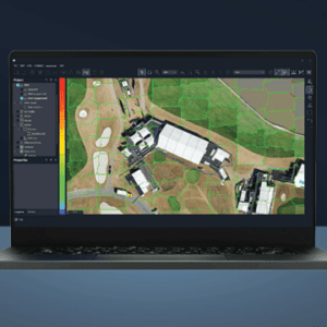
New Features Aim to Streamline Military and Commercial Mapping Operations SimActive Inc. has announced the release of Correlator3D™ Version 10.2, introducing significant upgrades designed to improve productivity and reduce editing time for both military and commercial users. The latest version of Correlator3D™ offers a comprehensive overhaul of mosaic and point cloud editing … [Read more...] about SimActive Releases Correlator3D Version 10.2 With Enhanced Editing Tools


