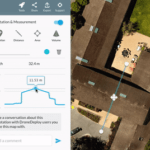
Sponsored by DroneDeploy — Easily leverage drone data in Autodesk AutoCAD, ArcGIS, and other software Elevation data is crucial to many industries. Businesses are beginning to look to drones as a faster, safer, more cost-effective alternative to traditional ground-based survey methods of capturing elevation data. Over the last few months, we’ve rolled out a number of tools … [Read more...] about DroneDeploy App Features Contour Export; Enables Operator to Beat Competition
GIS
GIS Drones Could Be a Game-Changer, Lift US Economy
(Source: directionsmag.com) By 2017, the economic impact of integrating unmanned aerial systems into the U.S. economy will exceed $13.6 billion and add 70,000 new jobs, according to forecasts by the Association of Unmanned Vehicle Systems International. By 2025, this will increase to 100,000 jobs with an impact of $82 billion. The use of small unmanned aerial vehicles, or … [Read more...] about GIS Drones Could Be a Game-Changer, Lift US Economy
Top Five Things You Need to Know About Drones and GIS
from directionsmag.com's Bill McNeil The mere mention of “drones” conjures thoughts of bombs and missiles raining down on unsuspecting bad guys. However, most of today’s drones, more accurately described as unmanned aerial vehicles (UAVs), are or will be focused on generating data to solve peace-time applications. UAVs range in size and cost from Northrop’s Global Hawk at … [Read more...] about Top Five Things You Need to Know About Drones and GIS


