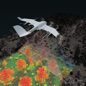
New Application Enables Efficient Infrastructure and Terrain Mapping Wingcopter has announced an expansion of its offerings to include long-range beyond visual line of sight (BVLOS) LiDAR surveying solutions. The Wingcopter 198, the company’s flagship drone, will be equipped with advanced laser scanning and camera systems to enable rapid, high-quality data … [Read more...] about Wingcopter Expands into Long-Range LiDAR Surveying
- Skip to main content
- Skip to secondary menu
- Skip to primary sidebar
- Skip to secondary sidebar
- Skip to footer
DRONELIFE
Stay up to date on all the latest Drone News


