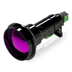
New infrared module targets extended-range surveillance and counter-UAS missions while addressing U.S. compliance needs Teledyne FLIR OEM has announced the launch of the Neutrino SX8 ISR 50-1000, the newest addition to its Neutrino ISR Series. The system is described as the longest-range thermal solution in the series to date and is designed for demanding … [Read more...] about Teledyne FLIR OEM Introduces Its Longest-Range Thermal ISR Camera to Date
drone sensors
Researchers Demonstrate “Lab-on-a-Drone” System for Real-Time Nitrate Monitoring
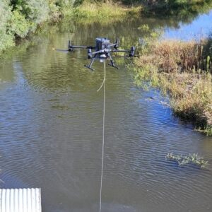
New drone-mounted sensor platform enables mid-air water analysis to support agriculture and water quality management Researchers have developed a new “lab-on-a-drone” system that can collect and analyze water samples in real time, according to a study reported in ACS Sensors. The system is designed to measure nitrate levels in hard-to-reach areas, including drainage ditches … [Read more...] about Researchers Demonstrate “Lab-on-a-Drone” System for Real-Time Nitrate Monitoring
How Tiny Bat-Inspired Drones Could Transform Search and Rescue Operations

Fog, near-darkness, and colored lights create a nightclub-like atmosphere in Worcester Polytechnic Institute's (WPI) drone testing area. As a palm-sized drone hovers through artificial smoke and snow, it approaches a plexiglass wall autonomously and turns back, all without a single camera. This is the PeAR Bat, a revolutionary bio-inspired drone that "sees" the world through … [Read more...] about How Tiny Bat-Inspired Drones Could Transform Search and Rescue Operations
From the Floor Of Intergeo 2025: GeoCue Announces NDAA-Compliant TrueView 641 Aerial LiDAR Sensor

GeoCue unveiled the TrueView 641 at INTERGEO 2025, a new NDAA-compliant aerial LiDAR sensor designed to meet growing demand from surveying and engineering companies across the United States and worldwide. The engineering-grade sensor addresses the increasing number of Federal, State, Local, and Educational contracts requiring NDAA compliance while maintaining cost accessibility … [Read more...] about From the Floor Of Intergeo 2025: GeoCue Announces NDAA-Compliant TrueView 641 Aerial LiDAR Sensor
AgEagle Launches RedEdge-P Green Camera for Precision Agriculture
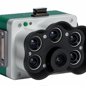
New multispectral sensor offers advanced imaging for farming, research, and environmental management AgEagle Aerial Systems Inc. (NYSE: UAVS) has announced the release of the RedEdge-P™ Green, a new multispectral camera designed to improve precision agriculture and related applications. The company says the sensor will provide farmers, researchers, and environmental managers … [Read more...] about AgEagle Launches RedEdge-P Green Camera for Precision Agriculture


