
A new partnership routes Spexi's aerial captures through Niantic Spatial's Reconstruction API to produce city-scale 3D Gaussian splats for enterprise customers. Niantic Spatial and Spexi Geospatial announced a strategic partnership that pairs Spexi's aerial data network with Niantic Spatial's 3D reconstruction pipeline. The deal positions drone imagery for physical AI as an … [Read more...] about Niantic Spatial and Spexi Turn Drone Imagery Into Physical AI
drone imagery
Spexi Orthomosaic Drone Imagery Now Available on SkyWatch Platform

SkyWatch has announced the addition of Spexi orthomosaic drone imagery to its platform, expanding access to standardized aerial data for mapping and analysis. The integration allows users to source ultra-high-resolution drone imagery directly through SkyWatch’s EXPLORE and HUB applications. With the launch, SkyWatch customers can access Spexi’s stitched, orthorectified imagery … [Read more...] about Spexi Orthomosaic Drone Imagery Now Available on SkyWatch Platform
Nearmap and New Light Deploy FEMA Disaster Response System.

Nearmap and New Light Technologies have deepened their collaboration to support the Federal Emergency Management Agency (FEMA) during major natural disasters. The partnership centers on using high‑recency aerial imagery and automated workflows to speed damage assessment, coordination, and relief‑funding decisions across presidential disaster declarations. How drones and … [Read more...] about Nearmap and New Light Deploy FEMA Disaster Response System.
SimActive’s Correlator3D™ 10.3: Revolutionizing Large-Scale Mapping with Enhanced Speed and Flexibility
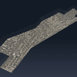
The latest update tackles big data challenges with optimized workflows and multi-platform integration, delivering powerful solutions for commercial and military applications. by DRONELIFE Staff Writer Ian J. McNabb Quebec-based software developer SimActive Inc. recently announced the release of the new Correlator3D™ Version 10.3, updating their popular mapping solution to … [Read more...] about SimActive’s Correlator3D™ 10.3: Revolutionizing Large-Scale Mapping with Enhanced Speed and Flexibility
Spexi Secures $11.5M Series A to Expand Ultra-High-Resolution Drone Imagery Network

Transforming Earth Imagery for Emergency Response, AI, and Emerging Technologies Spexi, a Vancouver-based technology company, has announced the completion of its $11.5 million USD Series A funding round, led by Blockchange Ventures. This milestone will support Spexi’s goal of building a scalable global network of drone pilots to deliver standardized, ultra-high-resolution … [Read more...] about Spexi Secures $11.5M Series A to Expand Ultra-High-Resolution Drone Imagery Network


