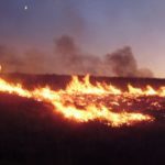
The Australian geospatial firm is using Correlator3D to generate orthomosaics from aerial imagery captured for wildfire prevention and land management projects. SimActive has announced that Landair Surveys is using its Correlator3D software to produce orthomosaics for planned burns mapping projects in Australia. The Montreal-based developer said the workflow is intended to … [Read more...] about Landair Surveys Uses SimActive Correlator3D for Planned Burns Mapping in Australia
- Skip to main content
- Skip to secondary menu
- Skip to primary sidebar
- Skip to secondary sidebar
- Skip to footer
DRONELIFE
Stay up to date on all the latest Drone News


