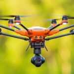
As wildfires raged in Canada, two innovative Canadian drone companies joined forces to provide responders with critical aerial data. InDro Robotics and Spexi Geospatial deployed commercial off the shelf drones weighing less than 250 grams, using the Spexigon automation platform, to provide decision makers with rapid damage assessment information and thermal imagery identifying … [Read more...] about Two Innovative Canadian Drone Companies Join Forces to Fight Kelowna Wildfires
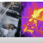
Thermal imaging
NPS-DDP Marks 47th Drone Donation for Pennsylvania Fire Department: Paying it Forward in the Public Safety Community
NPS-DDP stands for National Public Safety Drone Donation Program. The name says it all: the organization is focused on getting drones into the hands of communities who need it most, but may not have the public funding available to build a fleet. By collecting donations from individuals, drone manufacturers and partners, and NPS-DDP President Mark Langley's drone … [Read more...] about NPS-DDP Marks 47th Drone Donation for Pennsylvania Fire Department: Paying it Forward in the Public Safety Community
Teledyne FLIR Launches Development Kits for Fast Integration of the Hadron 640R, Thermal and Visible Dual Camera Module

Teledyne FLIR Releases Hadron 640R Development Kits for Fast Integration by DRONELIFE Staff Writer Ian M. Crosby Today, Teledyne FLIR released development kits for easy integration of its FLIR Hadron 640R thermal and visible dual camera module. Read more: DroneLife · Teledyne - FLIR - Hadron - 640R - Development - Kit The kits include hardware and reference software … [Read more...] about Teledyne FLIR Launches Development Kits for Fast Integration of the Hadron 640R, Thermal and Visible Dual Camera Module
Introducing the SIRAS UAV: Don’t Miss Teledyne FLIR’s Webinar, September 28
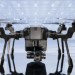
Register now for the Teledyne FLIR SIRAS webinar, September 28 at 1:00 pm PST! Teledyne FLIR introduced the new SIRAS commercial drone just before Commercial UAV Expo earlier this month. It's a drone that carries the world-class cameras that you expect from Teledyne FLIR - with a customer-driven design built to meet the needs of public safety and industrial customers at a … [Read more...] about Introducing the SIRAS UAV: Don’t Miss Teledyne FLIR’s Webinar, September 28
4 Reasons Drone Pilots Need Radiometric Thermal Zoom
Teledyne FLIR's VUE TZ20-R is a game changer for commercial drones, for applications from search and rescue to solar inspection. In a recent webinar, Teledyne FLIR's Kelly Brodbeck gives 4 reasons drone pilots need radiometric thermal zoom capabilities. The VUE TZ20-R's radiometric thermal zoom capabilities are the result of careful market research. Since FLIR was acquired … [Read more...] about 4 Reasons Drone Pilots Need Radiometric Thermal Zoom


