• Skip to main content
  • Skip to secondary menu
  • Skip to primary sidebar
  • Skip to secondary sidebar
  • Skip to footer
  • DroneRacingLife
  • DroneFlyers
  • Newsletter
DroneLife

DRONELIFE

Stay up to date on all the latest Drone News

  • News
  • Products
  • Industries
    • Agriculture
    • Construction
    • Delivery
    • Dual Use
    • Inspection
    • Public Safety
    • Surveying
  • Enthusiasts
  • Regulations
  • Business
  • Video
  • Podcasts

Mapping with Thermal Drones: Teledyne FLIR Talks Best Practices

December 15, 2021 by Miriam McNabb 5 Comments

mapping with thermal drones

Mapping with Thermal Drones: Teledyne FLIR Talks Best Practices

Teledyne FLIR are the world leaders in thermal imaging.  Mapping with thermal drones equipped with longwave infrared (LWIR) cameras – whether for solar farm or roof inspections, or for search and rescue or security missions, is getting more critical as drone flight beyond visual line of sight (BVLOS) gets closer for commercial drone applications.  New opportunities for applications like long linear pipeline inspections and long range search and rescue are expanding – and technology is evolving to meet growing demand.

In a webinar designed to help new users adopt proven best practices, the experts at Teledyne FLIR discuss the importance of resolution and altitude, emissivity and temperature accuracy, and when to use qualitative vs. quantitative data.

Mapping with Thermal Drones: Resolution and Altitude

mapping with thermal drones
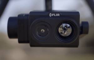
Mapping thermal data requires a high resolution camera – at a minimum, 640 pixels x 510 pixels.  Lower resolution simply won’t do the job well enough to provide useful commercial data.   As the altitude over the target increases, resolution per unit of area drops.  New developments in sensor technology provide a critical advantage in dealing with the issue: Teledyne FLIR’s new TZ20-R payload is designed to put more pixels on target at every zoom level, enabling operators to achieve the same level of resolution while flying at a greater distance.  It includes two thermal camera modules with different fields of view (FOV) to allow inspectors to maintain a safer stand-off distance, or for search and rescue missions to cover more ground.

Emissivity: The Key to Temperature Accuracy

Emissivity, say the experts at Teledyne FLIR, is by far the most important factor in getting accurate temperature data.  Emissivity refers to the ratio of energy emitted by an object compared to energy emitted by a blackbody: the surface’s ability to emit rather than reflect infrared energy.  Solar panels, for example, may have a uniform emissivity: but roofing materials vary widely.

Understanding emissivity of your target is crucial if you are looking for quantitative data.

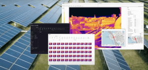
Qualitative vs. Quantitative Data: The Right Tool for the Job

Qualitative, or non-radiometric data measures the relative difference of a target from its surroundings.  Quantitative, or radiometric data, measures the temperature of a target.  Applications like search and rescue, fighting wildfires, roof inspections, or agriculture only require qualitative data to find a person, a hotspot in a wildfire, or a potential leak in a roof.  Commercial applications like solar or utility inspections, however, require quantitative data to know if a you have a real problem.

Radiometric cameras for applications that require quantitative data store temperature data for each pixel within an image.  Since thermal infrared energy from a surface can change based on angle of observation and time of day, it’s especially important to complete missions quickly and to pay attention to parameters like image overlap.

Some General Best Practices

1) Avoid Motion Blur. Fly low enough to serve the purpose, but slow enough to get good imagery – generally no faster than 12 – 15 mph.

2) Overlap and Sidelap.  For orthomosaics, the overlap and sidelap parameters are 80% by 80% for most processing engines.

3) Time of Day. Choose the time of day when any temperature difference or anomoly will be most pronounced.  Consider potential impacts of weather and solar loading from the sun.  For solar panel inspections, that’s before noon: but for roofing inspections, that’s at dawn or dusk when there are shadows.

Mapping with thermal drones is a complex application, but one that offers significant return on investment.  Sensors and processing software is continually evolving and improving to make the process easier and more accurate.  For more information on thermal orthomosaics and more, check out Teledyne FLIR’s extensive library of educational resources.

Miriam McNabb

Miriam McNabb is the Editor-in-Chief of DRONELIFE and CEO of JobForDrones, a professional drone services marketplace, and a fascinated observer of the emerging drone industry and the regulatory environment for drones. Miriam has penned over 3,000 articles focused on the commercial drone space and is an international speaker and recognized figure in the industry.  Miriam has a degree from the University of Chicago and over 20 years of experience in high tech sales and marketing for new technologies.
For drone industry consulting or writing, Email Miriam.

TWITTER:@spaldingbarker

Subscribe to DroneLife here.

Filed Under: Drone News Feeds, News, Sponsored Content, Thermal imaging Tagged With: drones for pipeline inspections, drones for roof inspections, drones for solar, flir, thermal camera, Thermal Imaging

Reader Interactions

Trackbacks

  1. 4 Reasons Radiometric Thermal Zoom for Drones – DroneLife says:
    January 25, 2022 at 8:43 am

    […] always find new uses for better and faster data.Read more about the VUE TZ20-R, best practices for mapping with thermal drones, and VUE TZ20 for public […]

    Reply
  2. 4 Reasons Radiometric Thermal Zoom for Drones » CDP Aerial Surveys says:
    January 24, 2022 at 6:06 pm

    […] more about the VUE TZ20-R, best practices for mapping with thermal drones, and VUE TZ20 for public […]

    Reply
  3. Mapping with Thermal Drones Teledyne FLIR – Game Up News says:
    December 15, 2021 at 9:30 pm

    […] Source link […]

    Reply
  4. Mapping with Thermal Drones: Teledyne FLIR Talks Best Practices Miriam McNabb — DRONELIFE – Romulan News Channel says:
    December 15, 2021 at 2:40 pm

    […] […]

    Reply
  5. Mapping with Thermal Drones: Teledyne FLIR Talks Best Practices – DronePilots.News says:
    December 15, 2021 at 2:24 pm

    […] post Mapping with Thermal Drones: Teledyne FLIR Talks Best Practices appeared first on […]

    Reply

Leave a Reply Cancel reply

Your email address will not be published. Required fields are marked *

Primary Sidebar

LATEST

Under the Ice: New SYOS Underwater Drone Targets Maritime Security and Antarctic Exploration

SYOS Introduces SU10 Underwater Drone for Multi-Domain Operations New uncrewed underwater vehicle expands company portfolio from air, land, and sea…

Continue Reading Under the Ice: New SYOS Underwater Drone Targets Maritime Security and Antarctic Exploration

Amprius and Matternet Expand Drone Delivery Battery Partnership

Silicon anode battery technology aims to improve range, charging time, and delivery economics for commercial drone operations Battery manufacturer Amprius…

Continue Reading Amprius and Matternet Expand Drone Delivery Battery Partnership

Kansas City Builds a World Cup-Era Drone Defense Network

Airspace Link and regional public safety agencies deploy a shared drone coordination and counter-UAS platform designed to support FIFA World…

Continue Reading Kansas City Builds a World Cup-Era Drone Defense Network

Autel Challenges FCC Covered List Decision, Distances Itself from DJI

Drone maker argues FCC relied on broad assumptions instead of company-specific analysis In a sharply worded filing with the Federal…

Continue Reading Autel Challenges FCC Covered List Decision, Distances Itself from DJI

Terra Drone Deploys Terra A2 Interceptor Drone to Ukraine Frontlines

The Japanese drone company brings its long-range, wide-area air defense platform into Ukrainian service alongside Terra A1 through a joint…

Continue Reading Terra Drone Deploys Terra A2 Interceptor Drone to Ukraine Frontlines

Tulip Tech Expands European UAV Battery Production with New Investment

Dutch battery company aims to strengthen drone supply chains and extend mission endurance European drone battery company Tulip Tech announced…

Continue Reading Tulip Tech Expands European UAV Battery Production with New Investment

Haryana’s Drone City Project Kicks Off With Indian Drone Company AVPL’s 11.5-Acre Campus

AVPL International will inaugurate Phase 1 of its proposed ₹80 crore Drone City Haryana project on May 16, 2026. The…

Continue Reading Haryana’s Drone City Project Kicks Off With Indian Drone Company AVPL’s 11.5-Acre Campus

Applied Aeronautics Launches SkyBeam Heavy Lift Drone Platform

New U.S.-Made quadrotor targets defense, public safety, and commercial operations with modular design and lower cost Applied Aeronautics has introduced…

Continue Reading Applied Aeronautics Launches SkyBeam Heavy Lift Drone Platform

FCC Adds More Drone Exemptions to Covered List Ban: Elevon Aerial, Air6 Systems

New FCC notice expands the list of conditionally approved foreign-made drone systems exempted from the agency’s broad Covered List restrictions…

Continue Reading FCC Adds More Drone Exemptions to Covered List Ban: Elevon Aerial, Air6 Systems

Students Compete in XPRIZE Wildfire Finals With AI Drone Firefighting

Silicon Valley students take on pros with wildfire drones. By Dronelife Features Editor Jim Magill

https://dronelife.com/wp-content/uploads/2026/05/Powerus_xFold-DragonH-Fire.mp4
The…

Continue Reading Students Compete in XPRIZE Wildfire Finals With AI Drone Firefighting

Secondary Sidebar

Footer

SPONSORED

Inspired Flight Gremsy IF800 VIO F1 drones geo week

What Will It Take to Strengthen U.S. Drone Manufacturing? A Conversation with Inspired Flight’s CEO

Global Mapper Mobile data collection

Collection Ground Control Points with Global Mapper Mobile

Military Drone Mapping Solutions

How SimActive’s Correlator3D™ is Revolutionizing Military Mapping: An Exclusive Interview with CEO Philippe Simard

Photogrammetry Accuracy Standards

SimActive Photogrammetry Software: Enabling Users to Meet Accuracy Standards for Over 20 Years

NACT Engineering Parrot ANAFI tether indoor shot

Smart Tether for Parrot ANAFI USA from NACT Engineering

Blue Marble, features global mapper, features Blue Marble

Check Out These New Features in Global Mapper v25 from Blue Marble

About Us | Contact Us | Advertise With Us | Write for Us | Privacy Policy | Terms of Service

The Trusted Source for the Business of Drones.

This website uses cookies and third party services. By clicking OK, you are agreeing to our privacy policy. ACCEPT

Manage consent

Privacy Overview

This website uses cookies to improve your experience while you navigate through the website. Out of these, the cookies that are categorized as necessary are stored on your browser as they are essential for the working of basic functionalities of the website. We also use third-party cookies that help us analyze and understand how you use this website. These cookies will be stored in your browser only with your consent. You also have the option to opt-out of these cookies. But opting out of some of these cookies may affect your browsing experience.
Necessary
Always Enabled
Necessary cookies are absolutely essential for the website to function properly. These cookies ensure basic functionalities and security features of the website, anonymously.
CookieDurationDescription
cookielawinfo-checkbox-analytics11 monthsThis cookie is set by GDPR Cookie Consent plugin. The cookie is used to store the user consent for the cookies in the category "Analytics".
cookielawinfo-checkbox-functional11 monthsThe cookie is set by GDPR cookie consent to record the user consent for the cookies in the category "Functional".
cookielawinfo-checkbox-necessary11 monthsThis cookie is set by GDPR Cookie Consent plugin. The cookies is used to store the user consent for the cookies in the category "Necessary".
cookielawinfo-checkbox-others11 monthsThis cookie is set by GDPR Cookie Consent plugin. The cookie is used to store the user consent for the cookies in the category "Other.
cookielawinfo-checkbox-performance11 monthsThis cookie is set by GDPR Cookie Consent plugin. The cookie is used to store the user consent for the cookies in the category "Performance".
viewed_cookie_policy11 monthsThe cookie is set by the GDPR Cookie Consent plugin and is used to store whether or not user has consented to the use of cookies. It does not store any personal data.
Functional
Functional cookies help to perform certain functionalities like sharing the content of the website on social media platforms, collect feedbacks, and other third-party features.
Performance
Performance cookies are used to understand and analyze the key performance indexes of the website which helps in delivering a better user experience for the visitors.
Analytics
Analytical cookies are used to understand how visitors interact with the website. These cookies help provide information on metrics the number of visitors, bounce rate, traffic source, etc.
Advertisement
Advertisement cookies are used to provide visitors with relevant ads and marketing campaigns. These cookies track visitors across websites and collect information to provide customized ads.
Others
Other uncategorized cookies are those that are being analyzed and have not been classified into a category as yet.
SAVE & ACCEPT