
LiDAR is one of the most important tools in the commercial drone industry. While it has been around since the 1960s when it was mounted to aircraft, its uses have expanded dramatically now that LiDAR can be used with commercial drones. What is LiDAR and how does it work? LiDAR is a remote sensing technology: sensors that are mounted to drones send a pulse from a laser … [Read more...] about 50 Ways to Love Your LiDAR: How LiDAR is Used in Commercial Drone Applications
Sensors
Insitu’s Photogrammetry Payload Pushes Theoretical Limits of Accuracy
Boeing subsidiary Insitu has revealed that its latest advancements in High Accuracy Photogrammetry (HAP) are pushing the theoretical limits of aerial photography at altitude. Last month Insitu’s latest prototype carried a HAP payload that can capture images accurate to within five centimeters (cm) horizontally and 10cm vertically. Insitu describes this new capability as … [Read more...] about Insitu’s Photogrammetry Payload Pushes Theoretical Limits of Accuracy
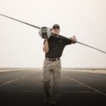
Endurance Flight without a Helicopter: Drone Tech Firm Harris Aerial Demonstrates LiDAR with Carrier H4 Hybrid
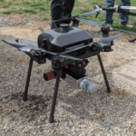
Aerial LiDAR surveys aren't new technology - but now U.S. - based Harris Aerial has demonstrated a new and ground-breaking way of performing them. LiDAR surveys provide critically accurate survey data, allowing for the creation of precise 3D models. LiDAR attached to a helicopter or other manned aircraft have been used for over 50 years in applications like natural hazard … [Read more...] about Endurance Flight without a Helicopter: Drone Tech Firm Harris Aerial Demonstrates LiDAR with Carrier H4 Hybrid
Drones Among Devices to Be Integrated with New Surveillance Technology

NEC Australia and CrowdOptic are jointly introducing an intelligent live video streaming security system enabled by real-time analysis of footage captured from fixed cameras and mobile camera sensors in body cams, smartphones, and drones. This marks a significant improvement on video surveillance and facial recognition, which today relies predominantly on footage captured … [Read more...] about Drones Among Devices to Be Integrated with New Surveillance Technology
Sentera Sensors Enable DJI Inspire 2 with Crop-Scouting Capabilities
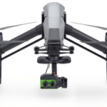
Sentera has announced its gimbaled Double 4K and Quad sensors for the DJI Inspire 2 drone. Sentera’s swappable precision crop health sensors paired with the Inspire 2 offers agronomists, crop consultants, and growers an economical way to capture diverse vegetation indices such as normalized difference vegetation index (NDVI) or normalized difference red edge (NDRE) data while … [Read more...] about Sentera Sensors Enable DJI Inspire 2 with Crop-Scouting Capabilities


