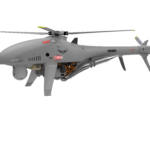
A Strategic Alliance: High Eye and Dutch Navy Partner on Advanced UAV Deployment In a recent announcement, High Eye revealed it has been awarded a contract by the Dutch Navy for its Airboxer VTOL (Vertical Take-Off and Landing) UAV (Unmanned Aerial Vehicle). This decision comes after a comprehensive evaluation of maritime VTOL UAV systems, leading to the selection of the … [Read more...] about High Eye Secures Contract with Dutch Navy for Innovative Airboxer VTOL UAV
Products
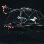
This Drone Steals Power from the Nearest Power Lines to Charge Its Battery and Keep Flying
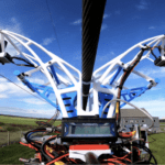
Fast Company calls it a "vampire drone," but the drone developed by a team of researchers at the University of Southern Denmark is designed to find and suck power, not blood. Dramatic headlines aside, the idea has significance for industrial drone flight beyond visual line of sight. With many drones still limited by relatively short battery life, the ability for a drone … [Read more...] about This Drone Steals Power from the Nearest Power Lines to Charge Its Battery and Keep Flying
Flyability Launches Elios 3 UT Payload in the US, Transforming Indoor Inspections
Revolutionizing Safety and Efficiency in Industrial Inspections with UTM Sensor Flyability, a leader in drone technology, has introduced its innovative Elios 3 UT Payload to the US market during a launch event in Denver, Colorado. This new technology is poised to revolutionize the way indoor inspections are conducted, particularly in challenging environments. The Elios 3 … [Read more...] about Flyability Launches Elios 3 UT Payload in the US, Transforming Indoor Inspections
Pioneering Precision: GEODNET’s Innovative Approach to Real-Time Kinematic Networking
How GEODNET is Transforming RTK Networking with Innovative Technologies and Strategic Partnership by DRONELIFE Contributing Editor Paul Rossi At AUVSI Xponential 2024, we sat down with Mike Horton of GEODNET to explore the latest advancements and strategies propelling their Real-Time Kinematic (RTK) network to the forefront of the geospatial technology market. GEODNET’s … [Read more...] about Pioneering Precision: GEODNET’s Innovative Approach to Real-Time Kinematic Networking
Pix4D Releases Enhanced PIX4Dcatch 2.0 with AR Features
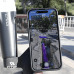
Latest update integrates professional augmented reality tools for improved precision in AEC sectors. Swiss-based Pix4D, a leading provider of drone and terrestrial mapping solutions, announced today the release of the upgraded version of their mobile scanning app, PIX4Dcatch 2.0. This update introduces augmented reality (AR) capabilities and expands compatibility with … [Read more...] about Pix4D Releases Enhanced PIX4Dcatch 2.0 with AR Features


