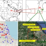
Enhancing Urban Air Mobility: UND's WindAware System Transforms UAS Operations with Advanced Wind Prediction Technology Researchers at the University of North Dakota (UND), a distinguished institution in the field of Unmanned Aircraft Systems (UASs), have unveiled a groundbreaking intelligent prediction system named “WindAware”. This system represents a significant step … [Read more...] about Innovative Wind Prediction System “WindAware” Could Enhance UAS Safety and Efficiency in Urban Airspace
Data analytics
Affordable Mapping Revolution: AerologixMaps Empowers Drone Businesses
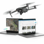
AerologixMaps: Affordable, Scalable Mapping Software In the rapidly evolving world of drone technology, a new mapping solution is filling a gap in the market for small and medium size drone businesses. AerologixMaps, developed by Australian drone industry pioneer Aerologix, is transforming drone footage into high-resolution maps with unprecedented affordability. With … [Read more...] about Affordable Mapping Revolution: AerologixMaps Empowers Drone Businesses
DJI Unveils DJI Modify: Intelligent 3D Model Editing Software for Seamless Integration with Enterprise Drones and Mapping Solutions

DJI Modify Enhances Workflow Efficiency in Surveying, Transportation, and Emergency Response with Interoperability and Smart Editing Capabilities by DRONELIFE Staff Writer Ian J. McNab DJI recently announced their new model editing software, DJI Modify, which is designed to integrate seamlessly with their range of enterprise drones and 3D modelling and mapping software, … [Read more...] about DJI Unveils DJI Modify: Intelligent 3D Model Editing Software for Seamless Integration with Enterprise Drones and Mapping Solutions
Innovative Drone Program Combats Global Landmine Crisis with AI Precision
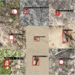
Safe Pro launches program to use drones, AI in landmine detection By DRONELIFE Features Editor Jim Magill Landmines, which kill or injure as many as 100,000 people in nations across the world every year, represent a global health crisis. Experts at the organization behind the international Minesweepers estimate that currently there are 110 million land mines in the ground in … [Read more...] about Innovative Drone Program Combats Global Landmine Crisis with AI Precision
Drones, Digital Twins, and Asset Digitization: vHive Wins 2023 Enabling Technology Leadership Award

Today, vHive, a global market leader specializing in enterprise asset digitization, announced it has been recognized by Frost & Sullivan as a recipient of the 2023 Enabling Technology Leadership Award. This award recognizes vHive as a leading Digital Twins software solution provider for multiple industries, including telecom, renewable energy, and cranes, based on its years … [Read more...] about Drones, Digital Twins, and Asset Digitization: vHive Wins 2023 Enabling Technology Leadership Award


