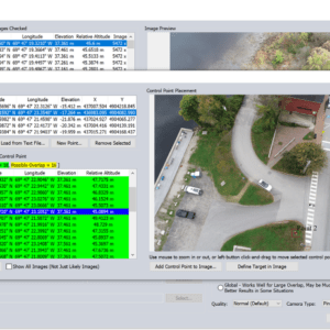
Unlocking the Power of Pixels: Efficient 3D Data Creation with Global Mapper Pro’s Pixels to Points Tool Sponsored Content. The all-in-one geospatial software, Global Mapper Pro®, really does it all! From raster data viewing and editing to vector feature creation, Global Mapper Pro goes further to include tools for point cloud analysis and classification. The Pixels to … [Read more...] about Creating 3D Data with Pixels to Points in Global Mapper Pro
Applications
Wingtra Unveils MAP61: The Game-Changing Mapping Payload Redefining Survey Efficiency
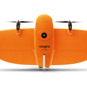
New Payload Slashes Time and Boosts Efficiency for Complex Survey Projects by DRONELIFE Staff Writer Ian J. McNabb At InterGeo this week, Switzerland-based drone manufacturer Wingtra recently announced their new MAP61 mapping payload, which they describe as “the most efficient mapping sensor on the market”. Able to capture up to 1,140 acres in a single flight, the MAP61 is … [Read more...] about Wingtra Unveils MAP61: The Game-Changing Mapping Payload Redefining Survey Efficiency
New Drone Security Provider Launches in Brazil

BIRDS Introduces Autonomous Security Solutions Tailored to Client Needs A new drone services provider, BIRDS, has launched operations in São Paulo, offering autonomous security systems designed to meet the security needs of major organizations throughout Brazil. BIRDS is the product of collaboration between three major companies: Speedbird Aero, a Brazilian UAS manufacturer … [Read more...] about New Drone Security Provider Launches in Brazil
Drone Express Wants to Become the Amazon of Drone Delivery
Drone Express Aims to Revolutionize Delivery with Marketplace Model and Rapid Service Expansion By DRONELIFE Features Editor Jim Magill Drone Express, based in Dayton, Ohio, is pursuing a business model that company officials hope will someday make it the Amazon of the drone delivery industry. The company, which recently launched delivery service operations in Winston-Salem, … [Read more...] about Drone Express Wants to Become the Amazon of Drone Delivery
Drone Technology Enhances Early Detection of Forest Fires
New System Offers Improved Accuracy for Firefighters Early detection of forest fires is critical to reducing their impact. Drones equipped with advanced cameras and artificial intelligence (AI) can provide firefighters with valuable time to respond quickly. This capability is becoming increasingly important as the risk of forest fires grows due to global warming. A study by … [Read more...] about Drone Technology Enhances Early Detection of Forest Fires


