
Recent Events Underscore Importance of Leadership in Navigating Regulatory Challenges The drone industry is facing an uncertain future as recent federal layoffs, FAA job cuts, and administrative shifts create confusion. The need for strong leadership has become even more pressing following recent incidents, including a tragic plane crash in Washington. As the industry seeks … [Read more...] about The Drone Industry Needs an Advocate at the Office of Science and Technology Policy
Strengthening Airport Defenses: The Growing Need for Better Counter-Drone Measures

Experts: More tools needed to protect airports from drones By DRONELIFE Features Editor Jim Magill (This is the fifth in a series of articles, examining the problems posed to critical infrastructure sites and other significant potential targets of drone incursions by hostile actors. Previous installments examined current federal laws pertaining to the use of counter-drone … [Read more...] about Strengthening Airport Defenses: The Growing Need for Better Counter-Drone Measures
Global Mapper v26.1 Enhances AI-Based Tools and User Experience

New Update Introduces Deep Learning Model Fine-Tuning and Improved Point Cloud Processing Blue Marble Geographics has released Global Mapper v26.1, introducing enhancements to its geographic information system (GIS) software. This update refines point cloud processing, expands deep learning capabilities, and improves customization options for users. Global Mapper is … [Read more...] about Global Mapper v26.1 Enhances AI-Based Tools and User Experience
UAV Navigation-Grupo Oesía and Primoco UAV SE Demonstrate Advanced Manned-Unmanned Teaming and Swarm Capabilities
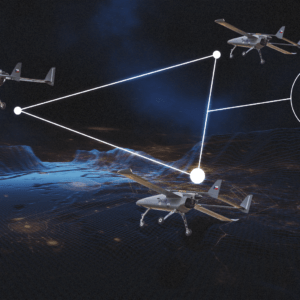
Successful Flight Test Highlights Future of Autonomous UAV Operations In a recent flight test, UAV Navigation-Grupo Oesía and Primoco UAV SE demonstrated the integration of advanced guidance, navigation, and control (GNC) technologies with teaming intelligence software. This test validated real-time swarm coordination and Manned-Unmanned Teaming (MUT) missions, showing the … [Read more...] about UAV Navigation-Grupo Oesía and Primoco UAV SE Demonstrate Advanced Manned-Unmanned Teaming and Swarm Capabilities
SimActive and Air Data Solutions Enhance Oil & Gas Mapping with High-Resolution Aerial Imagery

Correlator3D and Phase One Cameras Support Large-Scale Mapping Operations SimActive Inc.’s Correlator3D software is being used by Air Data Solutions (ADS) to map large oil and gas operations in South Texas. By integrating Phase One camera systems, ADS captures thousands of high-resolution images annually to produce detailed digital maps. Streamlining Aerial Mapping with … [Read more...] about SimActive and Air Data Solutions Enhance Oil & Gas Mapping with High-Resolution Aerial Imagery


