• Skip to main content
  • Skip to secondary menu
  • Skip to primary sidebar
  • Skip to secondary sidebar
  • Skip to footer
  • DroneRacingLife
  • DroneFlyers
  • Newsletter
DroneLife

DRONELIFE

Stay up to date on all the latest Drone News

  • News
  • Products
  • Industries
    • Agriculture
    • Construction
    • Delivery
    • Dual Use
    • Inspection
    • Public Safety
    • Surveying
  • Enthusiasts
  • Regulations
  • Business
  • Video
  • Podcasts

The Wing Free Drone Pilot App for Commercial and Recreational Users: OpenSky Launches Today in U.S.

June 29, 2021 by Miriam McNabb 97 Comments

Wing free drone pilot appThe Wing free drone pilot app, OpenSky, launched today: with features to simplify airspace intelligence for both commercial and recreational flyers.

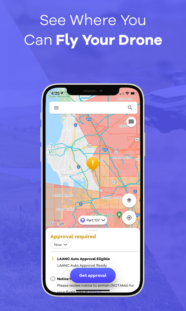
The Wing free drone pilot app has been available in Australia for a couple of years: OpenSky is available in the U. S. today for the first time. OpenSky is an adaptation of the software that Wing uses in it’s commercial drone delivery programs worldwide.  Wing says that the OpenSky system offers an easy to use app that clearly shows pilots of all levels where they can and cannot fly.

“Available for free in the Google Play and Apple’s App Store, the OpenSky app makes it very easy for drone flyers to abide by Federal Aviation Administration (FAA) airspace rules and regulations and automatically request authorization to fly in controlled airspace, including the airspace near airports and major cities.” says a Wing press release.

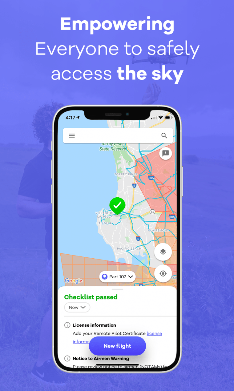
The OpenSky app brings a level of simplicity, familiarity and accuracy for drone operators across the U.S.  With OpenSky, recreational or commercial drone flyers can check FAA airspace information to see where they can and cannot fly, request permission from the FAA to fly in certain airspaces, and manage, and log their flights and permissions to their pilot profile.

Offering the app for free to both recreational and commercial flyers aligns wtih Wing’s consistent message: Open Skies for All.  “We’re releasing this app for free because we think it is paramount that all drone flyers — hobbyists, photographers, or commercial operators — are flying safely,” says Wing’s Lia Reich.

Wing is one of the companies investing time and money in enabling safe drone operation, in the hopes that their efforts will build a foundation for drone delivery and other commercial applications at scale.  “…Because OpenSky is powered by Google Maps, it brings simplicity and familiarity to drone pilots at every level of aviation experience. In this way, we hope to build support for the continued growth of the drone industry generally, and drone delivery specifically, here in the U.S., where Wing has plans to expand later this year,” says Reich.

After receiving positive feedback from drone flyers in Australia, as well as from Australia’s Civil Aviation Safety Authority (CASA), Wing began discussions with the FAA about bringing OpenSky to the U.S. The FAA has approved OpenSky as a Low Altitude Authorization and Notification Capability (LAANC) supplier, allowing the app to function as a real-time authorization tool for drone flyers wishing to operate in LAANC-controlled airspaces, which include areas surrounding hundreds of airports throughout the U.S. Without an FAA-approved LAANC supplier such as OpenSky, drone fliers would need to request authorization to operate in these areas days or weeks in advance. OpenSky can enable authorizations in seconds for operations like emergency response, commercial surveys, or film and photography sessions.

Why is a drone delivery company investing in an operator app? Because with nearly two million registered drones in the U.S. already, regulatory compliance of all drones will allow them to share the sky safely. Moreover, compliance will ultimately expand the uses and benefits of drones–among them emergency response, commercial inspections and contactless delivery–to more people.

OpenSky is one of many tools that operators can use to participate in the airspace. Wing believes that an open airspace system will encourage a stream of innovations that will support diversity, attract users and grow the entire drone industry – benefiting everyone.

Miriam McNabb

Miriam McNabb is the Editor-in-Chief of DRONELIFE and CEO of JobForDrones, a professional drone services marketplace, and a fascinated observer of the emerging drone industry and the regulatory environment for drones. Miriam has penned over 3,000 articles focused on the commercial drone space and is an international speaker and recognized figure in the industry.  Miriam has a degree from the University of Chicago and over 20 years of experience in high tech sales and marketing for new technologies.
For drone industry consulting or writing, Email Miriam.

TWITTER:@spaldingbarker

Subscribe to DroneLife here.

Filed Under: Drone News Feeds, Featured, Featured - FAA and Regulations, News Tagged With: airspace intelligence app, drone pilot app, LAANC, OpenSky, Wing

Reader Interactions

Trackbacks

  1. Google’s Wing launches free app to help drone pilots obey US regulations » Review Radar says:
    July 2, 2022 at 6:48 am

    […] is based on Google Maps, Wing tells DroneLife, and it’s color-coded to show areas where pilots can and can’t fly. Green areas are a-okay, but […]

    Reply
  2. OpenSky Wing Free Drone Pilot App Launched – Game Up News says:
    July 4, 2021 at 12:46 am

    […] Source link […]

    Reply
  3. Google’s Wing launches free app to assist drone pilots obey US rules - Yepmode News says:
    July 1, 2021 at 7:45 pm

    […] relies on Google Maps, Wing tells DroneLife, and it’s color-coded to indicate areas the place pilots can and might’t fly. Inexperienced […]

    Reply
  4. Google Wing Launches Free App To Help Drone Pilots Follow Rules | The DSLR Website says:
    July 1, 2021 at 7:19 am

    […] to DroneLife, Wing leverages Google Maps and uses color-coded areas to show where pilots can and cannot fly. […]

    Reply
  5. Google’s Wing launches free of charge application to enable drone pilots obey US regulations – News Time says:
    July 1, 2021 at 6:39 am

    […] is centered on Google Maps, Wing tells DroneLife, and it is colour-coded to demonstrate regions where pilots can and just can’t fly. […]

    Reply
  6. Google Wing Launches Free App to Help Drone Pilots Follow Rules - The Digital Journo says:
    July 1, 2021 at 12:52 am

    […] to DroneLife, Wing leverages Google Maps and uses color-coded areas to show where pilots can and cannot fly. […]

    Reply
  7. Google’s Wing launches free app to help drone pilots obey US regulations - IT News UG says:
    July 1, 2021 at 12:13 am

    […] is based on Google Maps, Wing tells DroneLife, and it’s color-coded to show areas where pilots can and can’t fly. Green areas are a-okay, but […]

    Reply
  8. Google Wing Launches Free App to Help Drone Pilots Follow Rules - 5starbase.com says:
    July 1, 2021 at 12:03 am

    […] to DroneLife, Wing leverages Google Maps and uses color-coded areas to show where pilots can and cannot fly. […]

    Reply
  9. Google’s Wing releases free app to take the pain out of drone flights – TRM Security Digest says:
    June 30, 2021 at 11:19 pm

    […] US, but that doesn’t mean it’ll be a headache to take your robotic flier for a spin. DroneLife and The Verge report that Google’s (really, Alphabet’s) drone delivery company Wing has […]

    Reply
  10. Google Wing Launches Free App to Assist Drone Pilots Observe Guidelines | Pure Profitz says:
    June 30, 2021 at 11:02 pm

    […] keeping with DroneLife, Wing leverages Google Maps and makes use of color-coded areas to point out the place pilots can […]

    Reply
  11. Google's Wing releases free app to take the pain out of drone flights - Knocking Live says:
    June 30, 2021 at 9:56 pm

    […] in the US, but that doesn’t mean it’ll be a headache to take your robotic flier for a spin. DroneLife and The Verge report that Google’s (really, Alphabet’s) drone delivery company Wing has […]

    Reply
  12. Google Wing Launches Free App To Help Drone Pilots Follow Rules | Camorabug says:
    June 30, 2021 at 9:28 pm

    […] on DroneLife, Wing leverages Google Maps and makes use of color-coded areas to point out the place pilots can […]

    Reply
  13. Google Wing lancia un'app gratuita per aiutare i piloti di droni a seguire le regole says:
    June 30, 2021 at 8:52 pm

    […] me DroneLifeWing sfrutta Google Maps e utilizza aree codificate a colori per mostrare dove i piloti possono e […]

    Reply
  14. Google Wing lanza una aplicación gratuita para ayudar a los pilotos de drones a seguir las reglas says:
    June 30, 2021 at 8:38 pm

    […] acuerdo a DronelifeEl ala mejora Google Maps y usa áreas codificadas por colores para mostrar dónde los pilotos […]

    Reply
  15. Google Wing Launches Free App to Help Drone Pilots Follow Rules - Best Epic Trends says:
    June 30, 2021 at 8:19 pm

    […] to DroneLife, Wing leverages Google Maps and uses color-coded areas to show where pilots can and cannot fly. […]

    Reply
  16. Google Wing ha lanzado una aplicación gratuita para ayudar a los pilotos de drones a seguir las reglas says:
    June 30, 2021 at 7:34 pm

    […] acuerdo a Drone‌life, El ala afecta a Google Maps y utiliza áreas codificadas por colores para mostrar a los pilotos […]

    Reply
  17. Google’s Wing launches free app to help drone pilots obey US regulations | The Verge - Flag of Ulysses says:
    June 30, 2021 at 6:39 pm

    […] is based on Google Maps, Wing tells DroneLife, and it’s color-coded to show areas where pilots can and can’t fly. Green areas are a-okay, but […]

    Reply
  18. Google Wing Launches Free App to Help Drone Pilots Follow Rules – Zulnaz News says:
    June 30, 2021 at 6:34 pm

    […] to DroneLife, Wing leverages Google Maps and uses color-coded areas to show where pilots can and cannot fly. […]

    Reply
  19. Το Google Wing λανσάρει δωρεάν εφαρμογή για να ανακουφίσει τον πόνο από τα drone says:
    June 30, 2021 at 6:27 pm

    […] για περιστροφή δεν σημαίνει ότι θα είναι πονοκέφαλος. Dronelife Και Στην άκρη Αναφέρετε ότι η Wing κατέχει την εταιρεία […]

    Reply
  20. Google Wing lanza una aplicación gratuita para ayudar a los pilotos de drones a seguir las reglas says:
    June 30, 2021 at 6:13 pm

    […] mi DroneLifeWing aprovecha Google Maps y usa áreas codificadas por colores para mostrar dónde los pilotos […]

    Reply
  21. Google Wing Launches Free App to Assist Drone Pilots Observe Guidelines - Cryptoinfoos says:
    June 30, 2021 at 6:06 pm

    […] line with DroneLife, Wing leverages Google Maps and makes use of color-coded areas to point out the place pilots can […]

    Reply
  22. Google Wing Launches Free App to Help Drone Pilots Follow Rules – SHOP WITH THE DURENS says:
    June 30, 2021 at 5:47 pm

    […] to DroneLife, Wing leverages Google Maps and uses color-coded areas to show where pilots can and cannot fly. […]

    Reply
  23. Google Wing Launches Free App to Help Drone Pilots Follow Rules - Ravi Prabhat says:
    June 30, 2021 at 5:44 pm

    […] to DroneExistence, Wing leverages Google Maps and makes use of color-coded spaces to turn the place pilots can and […]

    Reply
  24. Google Wing Launches Free App to Help Drone Pilots Follow Rules – Tech Zinga | Tech and Gadgets News says:
    June 30, 2021 at 5:35 pm

    […] to DroneLife, Wing leverages Google Maps and uses color-coded areas to show where pilots can and cannot fly. […]

    Reply
  25. Google's Wing lancia un'app gratuita per alleviare il dolore dei voli dei droni says:
    June 30, 2021 at 4:27 pm

    […] Negli Stati Uniti, ma ciò non significa che sarà faticoso portare il tuo drone a fare un giro. DroneLife E il il bordo Segnala che la società di consegna di droni di Google (già Alphabet) ha il petto […]

    Reply
  26. Google's Wing releases free app to take the pain out of drone flights says:
    June 30, 2021 at 4:13 pm

    […] the US, but that doesn’t mean it will be a headache to take your robotic aircraft for a spin. DroneLife is The Verge reports that Google’s drone delivery company (actually Alphabet) Wing has […]

    Reply
  27. Google’s Wing launches free app to help drone pilots obey US regulations – VIPortal INC says:
    June 30, 2021 at 3:21 pm

    […] is based on Google Maps, Wing tells DroneLife, and it’s color-coded to show areas where pilots can and can’t fly. Green areas are a-okay, but […]

    Reply
  28. Google’s Wing launches free app to help drone pilots obey US regulations - Jon Porter - The Daily Grand says:
    June 30, 2021 at 2:56 pm

    […] is based on Google Maps, Wing tells DroneLife, and it’s color-coded to show areas where pilots can and can’t fly. Green areas are a-okay, but […]

    Reply
  29. Google’s Wing launches free app to help drone pilots obey US regulations – E.P.G.N. Network says:
    June 30, 2021 at 2:55 pm

    […] is based on Google Maps, Wing tells DroneLife, and it’s color-coded to show areas where pilots can and can’t fly. Green areas are a-okay, but […]

    Reply
  30. Google's Wing launches free app to ease drone theft - ondequando says:
    June 30, 2021 at 2:52 pm

    […] but that doesn’t mean it’ll be a headache to take a ride with your robotic flyer. DroneLife and The edge reports that Google’s (really, Alphabet) drone delivery company Wing has […]

    Reply
  31. Google's Wing releases free app to take the pain out of drone flights - DzTechno - DZTECHNO! says:
    June 30, 2021 at 2:41 pm

    […] in the US, but that doesn’t mean it’ll be a headache to take your robotic flier for a spin. DroneLife and The Verge report that Google’s (really, Alphabet’s) drone delivery company Wing has […]

    Reply
  32. Wing de Google lanza una aplicación gratuita para aliviar el dolor de los vuelos con drones says:
    June 30, 2021 at 2:35 pm

    […] pero eso no significa que sea un dolor de cabeza llevar a su aviador robótico a dar un paseo. DroneLife y El borde informe que Wing, la empresa de entrega de drones de Google (en realidad, Alphabet), […]

    Reply
  33. Google’s Wing releases free app to take the pain out of drone flights | GoFixer says:
    June 30, 2021 at 2:02 pm

    […] in the US, but that doesn’t mean it’ll be a headache to take your robotic flier for a spin. DroneLife and The Verge report that Google’s (really, Alphabet’s) drone delivery company Wing has […]

    Reply
  34. Google’s Wing releases free app to take the pain out of drone flights | James News says:
    June 30, 2021 at 1:59 pm

    […] in the US, but that doesn’t mean it’ll be a headache to take your robotic flier for a spin. DroneLife and The Verge report that Google’s (really, Alphabet’s) drone delivery company Wing has […]

    Reply
  35. Google's Wing releases free app to take the pain out of drone flights- techcodex.com says:
    June 30, 2021 at 1:58 pm

    […] in the US, but that doesn’t mean it’ll be a headache to take your robotic flier for a spin. DroneLife and The Verge report that Google’s (really, Alphabet’s) drone delivery company Wing has […]

    Reply
  36. Google’s Wing releases free app to take the pain out of drone flights - Best Sellers Bazaar says:
    June 30, 2021 at 1:54 pm

    […] in the US, but that doesn’t mean it’ll be a headache to take your robotic flier for a spin. DroneLife and The Verge report that Google’s (really, Alphabet’s) drone delivery company Wing has […]

    Reply
  37. Google’s Wing releases free app to take the pain out of drone flights – Android Authority – Zulnaz News says:
    June 30, 2021 at 1:50 pm

    […] in the US, but that doesn’t mean it’ll be a headache to take your robotic flier for a spin. DroneLife and The Verge report that Google’s (really, Alphabet’s) drone delivery company Wing has […]

    Reply
  38. Google’s Wing releases free app to take the pain out of drone flights – View Plugg says:
    June 30, 2021 at 1:34 pm

    […] in the US, but that doesn’t mean it’ll be a headache to take your robotic flier for a spin. DroneLife and The Verge report that Google’s (really, Alphabet’s) drone delivery company Wing has […]

    Reply
  39. Google's Wing releases free app to take the pain out of drone flights - Allas-Start says:
    June 30, 2021 at 1:32 pm

    […] in the US, but that doesn’t mean it’ll be a headache to take your robotic flier for a spin. DroneLife and The Verge report that Google’s (really, Alphabet’s) drone delivery company Wing has […]

    Reply
  40. Google's Wing releases free app to take the pain out of drone flights - Android Authority - Creators Empire says:
    June 30, 2021 at 1:31 pm

    […] now drone flight license But that doesn’t mean spinning the robot pliers will be a headache. drone life and The Verge Google’s (really Alphabet’s) drone delivery company Wing release OpenSky […]

    Reply
  41. Google’s Wing releases free app to take the pain out of drone flights - Simturax says:
    June 30, 2021 at 1:27 pm

    […] in the US, but that doesn’t mean it’ll be a headache to take your robotic flier for a spin. DroneLife and The Verge report that Google’s (really, Alphabet’s) drone delivery company Wing has […]

    Reply
  42. Google’s Wing releases free app to take the pain out of drone flights ⋆ 💫 Kozmofeed says:
    June 30, 2021 at 1:27 pm

    […] in the US, but that doesn’t mean it’ll be a headache to take your robotic flier for a spin. DroneLife and The Verge report that Google’s (really, Alphabet’s) drone delivery company Wing has […]

    Reply
  43. Google's Wing releases free app to take the pain out of drone flights | Wetter Forum says:
    June 30, 2021 at 1:21 pm

    […] in the US, but that doesn’t mean it’ll be a headache to take your robotic flier for a spin. DroneLife and The Verge report that Google’s (really, Alphabet’s) drone delivery company Wing has […]

    Reply
  44. Google’s Wing launches free app to help drone pilots obey US regulations – CHRISTIAN says:
    June 30, 2021 at 1:10 pm

    […] is based on Google Maps, Wing tells DroneLife, and it’s color-coded to show areas where pilots can and can’t fly. Green areas are a-okay, but […]

    Reply
  45. Google’s Wing launches free app to help drone pilots obey US regulations - frogfactoryblog.com says:
    June 30, 2021 at 1:01 pm

    […] is based on Google Maps, Wing tells DroneLife, and it’s color-coded to show areas where pilots can and can’t fly. Green areas are a-okay, but […]

    Reply
  46. Google’s Wing launches free app to help drone pilots obey US regulationsJon Porteron 2021-06-30 at 14:54 The Verge - All Posts - tutorialeu says:
    June 30, 2021 at 12:44 pm

    […] is based on Google Maps, Wing tells DroneLife, and it’s color-coded to show areas where pilots can and can’t fly. Green areas are a-okay, but […]

    Reply
  47. Google’s Wing launches free app to help drone pilots obey US regulations – VIP Finance says:
    June 30, 2021 at 12:41 pm

    […] is based on Google Maps, Wing tells DroneLife, and it’s color-coded to show areas where pilots can and can’t fly. Green areas are a-okay, but […]

    Reply
  48. Google’s Wing launches free app to help drone pilots obey US regulations | Masoud ILDEREMI says:
    June 30, 2021 at 12:40 pm

    […] is based on Google Maps, Wing tells DroneLife, and it’s color-coded to show areas where pilots can and can’t fly. Green areas are a-okay, but […]

    Reply
  49. Google’s Wing launches free app to help drone pilots obey US regulations - Fresh Tech Daily says:
    June 30, 2021 at 12:05 pm

    […] is based on Google Maps, Wing tells DroneLife, and it’s color-coded to show areas where pilots can and can’t fly. Green areas are a-okay, but […]

    Reply
  50. 谷歌的 Wing 推出免費應用程序以幫助無人機飛行員遵守美國法規 – 創科技新聞 says:
    June 30, 2021 at 12:01 pm

    […] 基於谷歌地圖,Wing 告訴DroneLife […]

    Reply
  51. Google's Wing Lance Une Application Gratuite Pour Aider Les Pilotes De Drones à Respecter La Réglementation Américaine - Tech Tribune France says:
    June 30, 2021 at 11:58 am

    […] est basé sur Google Maps, Wing raconte DroneLife, et il est codé par couleur pour montrer les zones où les pilotes peuvent et ne peuvent pas […]

    Reply
  52. Google’s Wing launches free app to help drone pilots obey US regulations - PeakNews says:
    June 30, 2021 at 11:56 am

    […] is based on Google Maps, Wing tells DroneLife, and it’s color-coded to show areas where pilots can and can’t fly. Green areas are a-okay, but […]

    Reply
  53. Google’s Wing launches free app to help drone pilots obey US regulations - Fancy Hints says:
    June 30, 2021 at 11:54 am

    […] is based on Google Maps, Wing tells DroneLife, and it’s color-coded to show areas where pilots can and can’t fly. Green areas are a-okay, but […]

    Reply
  54. Google’s Wing launches free app to help drone pilots obey US regulations – Latest Technology News says:
    June 30, 2021 at 11:51 am

    […] is based on Google Maps, Wing tells DroneLife, and it’s color-coded to show areas where pilots can and can’t fly. Green areas are a-okay, but […]

    Reply
  55. Google’s Wing launches free app to help drone pilots obey US regulations - Neotizen News says:
    June 30, 2021 at 11:49 am

    […] is based on Google Maps, Wing tells DroneLife, and it’s color-coded to show areas where pilots can and can’t fly. Green areas are a-okay, but […]

    Reply
  56. Google’s Wing launches free app to help drone pilots obey US regulations – buzzas says:
    June 30, 2021 at 11:48 am

    […] is based on Google Maps, Wing tells DroneLife, and it’s color-coded to show areas where pilots can and can’t fly. Green areas are a-okay, but […]

    Reply
  57. Google’s Wing launches free app to help drone pilots obey US regulations – mrhagen.net says:
    June 30, 2021 at 11:36 am

    […] is based on Google Maps, Wing tells DroneLife, and it’s color-coded to show areas where pilots can and can’t fly. Green areas are a-okay, but […]

    Reply
  58. Google’s Wing launches free app to help drone pilots obey US regulations - News Concerns says:
    June 30, 2021 at 11:33 am

    […] is based on Google Maps, Wing tells DroneLife, and it’s color-coded to show areas where pilots can and can’t fly. Green areas are a-okay, but […]

    Reply
  59. Google’s Wing launches free app to help drone pilots obey US regulations - Tech Dram says:
    June 30, 2021 at 11:30 am

    […] is based on Google Maps, Wing tells DroneLife, and it’s color-coded to show areas where pilots can and can’t fly. Green areas are a-okay, but […]

    Reply
  60. Google’s Wing launches free app to help drone pilots obey US regulations - The News Motion says:
    June 30, 2021 at 11:28 am

    […] is based on Google Maps, Wing tells DroneLife, and it’s color-coded to show areas where pilots can and can’t fly. Green areas are a-okay, but […]

    Reply
  61. Google’s Wing launches free app to help drone pilots obey US regulations | K2C Digital says:
    June 30, 2021 at 11:27 am

    […] is based on Google Maps, Wing tells DroneLife, and it’s color-coded to show areas where pilots can and can’t fly. Green areas are a-okay, but […]

    Reply
  62. Google’s Wing launches free app to help drone pilots obey US regulations- techcodex.com says:
    June 30, 2021 at 11:22 am

    […] is based on Google Maps, Wing tells DroneLife, and it’s color-coded to show areas where pilots can and can’t fly. Green areas are a-okay, but […]

    Reply
  63. Google’s Wing launches free app to help drone pilots obey US regulations – PublicSwamp says:
    June 30, 2021 at 11:21 am

    […] is based on Google Maps, Wing tells DroneLife, and it’s color-coded to show areas where pilots can and can’t fly. Green areas are a-okay, but […]

    Reply
  64. Google’s Wing launches free app to help drone pilots obey US regulations – upcomesnews.com says:
    June 30, 2021 at 11:19 am

    […] is based on Google Maps, Wing tells DroneLife, and it’s color-coded to show areas where pilots can and can’t fly. Green areas are a-okay, but […]

    Reply
  65. Google’s Wing launches free app to help drone pilots obey US regulations – MagicSpan says:
    June 30, 2021 at 11:18 am

    […] is based on Google Maps, Wing tells DroneLife, and it’s color-coded to show areas where pilots can and can’t fly. Green areas are a-okay, but […]

    Reply
  66. Google’s Wing launches free app to help drone pilots obey US regulations – New Liberty News says:
    June 30, 2021 at 11:16 am

    […] is based on Google Maps, Wing tells DroneLife, and it’s color-coded to show areas where pilots can and can’t fly. Green areas are a-okay, but […]

    Reply
  67. Google’s Wing launches free app to help drone pilots obey US regulations - Magazine Mediapur says:
    June 30, 2021 at 11:16 am

    […] is based on Google Maps, Wing tells DroneLife, and it’s color-coded to show areas where pilots can and can’t fly. Green areas are a-okay, but […]

    Reply
  68. Google’s Wing launches free app to help drone pilots obey US regulations - times.business says:
    June 30, 2021 at 11:15 am

    […] is based on Google Maps, Wing tells DroneLife, and it’s color-coded to show areas where pilots can and can’t fly. Green areas are a-okay, but […]

    Reply
  69. Google’s Wing Launches Free App To Help Drone Pilots Obey US Regulations - Learnings says:
    June 30, 2021 at 11:15 am

    […] is based on Google Maps, Wing tells DroneLife, and it’s color-coded to show areas where pilots can and can’t fly. Green areas are a-okay, but […]

    Reply
  70. Google’s Wing launches free app to help drone pilots obey US regulations - The Verge says:
    June 30, 2021 at 11:14 am

    […] is based on Google Maps, Wing tells DroneLife, and it’s color-coded to show areas where pilots can and can’t fly. Green areas are a-okay, but […]

    Reply
  71. Google’s Wing launches free app to help drone pilots obey US regulations - Wilson's Media says:
    June 30, 2021 at 11:13 am

    […] is based on Google Maps, Wing tells DroneLife, and it’s color-coded to show areas where pilots can and can’t fly. Green areas are a-okay, but […]

    Reply
  72. Google’s Wing launches free app to help drone pilots obey US regulations – Hey says:
    June 30, 2021 at 11:13 am

    […] is based on Google Maps, Wing tells DroneLife, and it’s color-coded to show areas where pilots can and can’t fly. Green areas are a-okay, but […]

    Reply
  73. Google’s Wing launches free app to help drone pilots obey US regulationsNews World WideLatest News says:
    June 30, 2021 at 11:12 am

    […] is based on Google Maps, Wing tells DroneLife, and it’s color-coded to show areas where pilots can and can’t fly. Green areas are a-okay, but […]

    Reply
  74. Google’s Wing launches free app to help drone pilots obey US regulations - InstaBumper Blog says:
    June 30, 2021 at 11:11 am

    […] is based on Google Maps, Wing tells DroneLife, and it’s color-coded to show areas where pilots can and can’t fly. Green areas are a-okay, but […]

    Reply
  75. Google’s Wing launches free app to help drone pilots obey US regulations - Gamezigo says:
    June 30, 2021 at 11:10 am

    […] is based on Google Maps, Wing tells DroneLife, and it’s color-coded to show areas where pilots can and can’t fly. Green areas are a-okay, but […]

    Reply
  76. Google’s Wing launches free app to help drone pilots obey US regulations - Verve times says:
    June 30, 2021 at 11:10 am

    […] is based on Google Maps, Wing tells DroneLife, and it’s color-coded to show areas where pilots can and can’t fly. Green areas are a-okay, but […]

    Reply
  77. Google’s Wing launches free app to help drone pilots obey US regulations – Yeah, you slippin says:
    June 30, 2021 at 11:09 am

    […] is based on Google Maps, Wing tells DroneLife, and it’s color-coded to show areas where pilots can and can’t fly. Green areas are a-okay, but […]

    Reply
  78. Google’s Wing launches free app to help drone pilots obey US regulations - ISFeed says:
    June 30, 2021 at 11:09 am

    […] is based on Google Maps, Wing tells DroneLife, and it’s color-coded to show areas where pilots can and can’t fly. Green areas are a-okay, but […]

    Reply
  79. Google’s Wing launches free app to help drone pilots obey US regulations – ਸੱਚ ਦੀ ਅਵਾਜ says:
    June 30, 2021 at 11:08 am

    […] is based on Google Maps, Wing tells DroneLife, and it’s color-coded to show areas where pilots can and can’t fly. Green areas are a-okay, but […]

    Reply
  80. Google’s Wing launches free app to help drone pilots obey US regulations - Simturax says:
    June 30, 2021 at 11:08 am

    […] is based on Google Maps, Wing tells DroneLife, and it’s color-coded to show areas where pilots can and can’t fly. Green areas are a-okay, but […]

    Reply
  81. Google’s Wing launches free app to assist drone pilots obey US rules – Shajjad Hossain says:
    June 30, 2021 at 11:07 am

    […] relies on Google Maps, Wing tells DroneLife, and it’s color-coded to point out areas the place pilots can and might’t fly. Inexperienced […]

    Reply
  82. Google’s Wing launches free app to help drone pilots obey US regulations – Hot News Station says:
    June 30, 2021 at 11:07 am

    […] is based on Google Maps, Wing tells DroneLife, and it’s color-coded to show areas where pilots can and can’t fly. Green areas are a-okay, but […]

    Reply
  83. Google’s Wing launches free app to help drone pilots obey US regulations – TECHNO SPARKLE says:
    June 30, 2021 at 11:06 am

    […] is based on Google Maps, Wing tells DroneLife, and it’s color-coded to show areas where pilots can and can’t fly. Green areas are a-okay, but […]

    Reply
  84. Google’s Wing launches free app to assist drone pilots obey US rules – Tech News Feed by Milkyweb Technologies says:
    June 30, 2021 at 11:05 am

    […] relies on Google Maps, Wing tells DroneLife, and it’s color-coded to point out areas the place pilots can and might’t fly. Inexperienced […]

    Reply
  85. Google's Wing launches free app to help drone pilots comply with US regulations says:
    June 30, 2021 at 11:05 am

    […] is based on Google Maps, Wing tells DroneLife, and it’s color-coded to show areas where pilots can and cannot fly. Green areas are okay, […]

    Reply
  86. Google’s Wing launches free app to help drone pilots obey US regulations - says:
    June 30, 2021 at 11:04 am

    […] is based on Google Maps, Wing tells DroneLife, and it’s color-coded to show areas where pilots can and can’t fly. Green areas are a-okay, but […]

    Reply
  87. Google’s Wing launches free app to help drone pilots obey US regulations – The Sky Magazine says:
    June 30, 2021 at 11:03 am

    […] is based on Google Maps, Wing tells DroneLife, and it’s color-coded to show areas where pilots can and can’t fly. Green areas are a-okay, but […]

    Reply
  88. Google's Wing launches a free app to help drone pilots obey US regulations. - Journal Beat says:
    June 30, 2021 at 11:03 am

    […] is based on Google Maps, Wing He says Dronelifeand it is color-coded to show the areas where pilots can and cannot fly. Green areas are fine, but […]

    Reply
  89. Google’s Wing launches free app to help drone pilots obey US regulations | CATCHSTORY says:
    June 30, 2021 at 11:02 am

    […] is based on Google Maps, Wing tells DroneLife, and it’s color-coded to show areas where pilots can and can’t fly. Green areas are a-okay, but […]

    Reply
  90. Google’s Wing launches free app to help drone pilots obey US regulations | Stock Market Pioneer says:
    June 30, 2021 at 11:02 am

    […] is based on Google Maps, Wing tells DroneLife, and it’s color-coded to show areas where pilots can and can’t fly. Green areas are a-okay, but […]

    Reply
  91. Google’s Wing launches free app to help drone pilots obey US regulations | Sports Grind Entertainment says:
    June 30, 2021 at 11:01 am

    […] is based on Google Maps, Wing tells DroneLife, and it’s color-coded to show areas where pilots can and can’t fly. Green areas are a-okay, but […]

    Reply
  92. Google’s Wing launches free app to help drone pilots obey US regulations - BonneInfo says:
    June 30, 2021 at 11:00 am

    […] is based on Google Maps, Wing tells DroneLife, and it’s color-coded to show areas where pilots can and can’t fly. Green areas are a-okay, but […]

    Reply
  93. Google’s Wing launches free app to help drone pilots obey US regulations - Best Buy Reviews says:
    June 30, 2021 at 10:59 am

    […] is based upon Google Maps, Wing tells DroneLife, and also it’s color-coded to reveal locations where pilots can and also can not fly. […]

    Reply
  94. Google’s Wing launches free app to help drone pilots obey US regulations ⋆ 💫 Kozmofeed says:
    June 30, 2021 at 10:56 am

    […] is based on Google Maps, Wing tells DroneLife, and it’s color-coded to show areas where pilots can and can’t fly. Green areas are a-okay, but […]

    Reply
  95. Google’s Wing launches free app to help drone pilots obey US regulations says:
    June 30, 2021 at 10:55 am

    […] is based on Google Maps, Wing tells DroneLife, and it’s color-coded to show areas where pilots can and can’t fly. Green areas are a-okay, but […]

    Reply
  96. OpenSky Wing Free Drone Pilot App Launched – Dronestagram Blog says:
    June 30, 2021 at 10:01 am

    […] More… […]

    Reply
  97. OpenSky Wing Free Drone Pilot App Launched - Go Drones Blog says:
    June 30, 2021 at 8:19 am

    […] OpenSky, the Wing Free Drone Pilot App for both recreational and commercial drone flyers, launches today with LAANC capabilities and more. Source […]

    Reply

Leave a Reply Cancel reply

Your email address will not be published. Required fields are marked *

Primary Sidebar

LATEST

Drones Transform Warehouse Operations at Southern Glazer’s

Corvus Robotics rollout supports supply chain transformation and improved warehouse performance Southern Glazer’s Wine & Spirits has expanded its use…

Continue Reading Drones Transform Warehouse Operations at Southern Glazer’s

Flying Lion Launches DroneBooth for Rapid Drone Dock Deployment

Portable system enables 24×7 operations without fixed power or internet infrastructure Flying Lion, Inc. has announced the release of DroneBooth™,…

Continue Reading Flying Lion Launches DroneBooth for Rapid Drone Dock Deployment

BRINC Launch Signals Next Phase of U.S. Public Safety Drone Industry

New Guardian platform and Seattle factory highlight scaling pressure, public safety adoption, and policy shifts shaping the U.S. drone market.…

Continue Reading BRINC Launch Signals Next Phase of U.S. Public Safety Drone Industry

Red Force as a Service Brings Realistic Counter-UAS Testing to Pendleton

Pendleton UAS Range (PUR) and Gambit have partnered to deliver Red Force as a Service for counter-UAS testing, validation, and…

Continue Reading Red Force as a Service Brings Realistic Counter-UAS Testing to Pendleton

Unifly Expands European Drone Consulting with New Acquisition

Unifly acquires EuroUSC-Benelux to expand drone regulatory and compliance consulting across Belgium, the Netherlands, Luxembourg, and France. Unifly, a global…

Continue Reading Unifly Expands European Drone Consulting with New Acquisition

Photojournalist Challenges FAA Temporary Flight Restriction as First Amendment Violation

By Dronelife Features Editor Jim Magill A drone pilot has sued the FAA, claiming that an FAA temporary flight restriction…

Continue Reading Photojournalist Challenges FAA Temporary Flight Restriction as First Amendment Violation

Terra Drone Announces Entry into Defense Market with Planned U.S. Subsidiary

Company outlines strategy to expand unmanned systems across global defense markets Tokyo-based Terra Drone Corporation has announced a full-scale entry…

Continue Reading Terra Drone Announces Entry into Defense Market with Planned U.S. Subsidiary

China Leads Global Surge in Counter-Drone Patents as Security Concerns Grow

New data highlights rising investment in jamming, laser, and microwave systems as governments and industry seek scalable drone defense solutions…

Continue Reading China Leads Global Surge in Counter-Drone Patents as Security Concerns Grow

Texas A&M Team Uses Drones to Map Ocean Currents

By Dronelife Features Editor Jim Magill When an offshore platform experiences a massive blowout resulting in an oil spill covering…

Continue Reading Texas A&M Team Uses Drones to Map Ocean Currents

ePropelled Opens UK Hub to Scale UAV Propulsion

ePropelled has opened its new Global Innovation Centre in Coventry, expanding capacity for UAV propulsion and power systems. The facility…

Continue Reading ePropelled Opens UK Hub to Scale UAV Propulsion

Secondary Sidebar

Footer

SPONSORED

Inspired Flight Gremsy IF800 VIO F1 drones geo week

What Will It Take to Strengthen U.S. Drone Manufacturing? A Conversation with Inspired Flight’s CEO

Global Mapper Mobile data collection

Collection Ground Control Points with Global Mapper Mobile

Military Drone Mapping Solutions

How SimActive’s Correlator3D™ is Revolutionizing Military Mapping: An Exclusive Interview with CEO Philippe Simard

Photogrammetry Accuracy Standards

SimActive Photogrammetry Software: Enabling Users to Meet Accuracy Standards for Over 20 Years

NACT Engineering Parrot ANAFI tether indoor shot

Smart Tether for Parrot ANAFI USA from NACT Engineering

Blue Marble, features global mapper, features Blue Marble

Check Out These New Features in Global Mapper v25 from Blue Marble

About Us | Contact Us | Advertise With Us | Write for Us | Privacy Policy | Terms of Service

The Trusted Source for the Business of Drones.

This website uses cookies and third party services. By clicking OK, you are agreeing to our privacy policy. ACCEPT

Manage consent

Privacy Overview

This website uses cookies to improve your experience while you navigate through the website. Out of these, the cookies that are categorized as necessary are stored on your browser as they are essential for the working of basic functionalities of the website. We also use third-party cookies that help us analyze and understand how you use this website. These cookies will be stored in your browser only with your consent. You also have the option to opt-out of these cookies. But opting out of some of these cookies may affect your browsing experience.
Necessary
Always Enabled
Necessary cookies are absolutely essential for the website to function properly. These cookies ensure basic functionalities and security features of the website, anonymously.
CookieDurationDescription
cookielawinfo-checkbox-analytics11 monthsThis cookie is set by GDPR Cookie Consent plugin. The cookie is used to store the user consent for the cookies in the category "Analytics".
cookielawinfo-checkbox-functional11 monthsThe cookie is set by GDPR cookie consent to record the user consent for the cookies in the category "Functional".
cookielawinfo-checkbox-necessary11 monthsThis cookie is set by GDPR Cookie Consent plugin. The cookies is used to store the user consent for the cookies in the category "Necessary".
cookielawinfo-checkbox-others11 monthsThis cookie is set by GDPR Cookie Consent plugin. The cookie is used to store the user consent for the cookies in the category "Other.
cookielawinfo-checkbox-performance11 monthsThis cookie is set by GDPR Cookie Consent plugin. The cookie is used to store the user consent for the cookies in the category "Performance".
viewed_cookie_policy11 monthsThe cookie is set by the GDPR Cookie Consent plugin and is used to store whether or not user has consented to the use of cookies. It does not store any personal data.
Functional
Functional cookies help to perform certain functionalities like sharing the content of the website on social media platforms, collect feedbacks, and other third-party features.
Performance
Performance cookies are used to understand and analyze the key performance indexes of the website which helps in delivering a better user experience for the visitors.
Analytics
Analytical cookies are used to understand how visitors interact with the website. These cookies help provide information on metrics the number of visitors, bounce rate, traffic source, etc.
Advertisement
Advertisement cookies are used to provide visitors with relevant ads and marketing campaigns. These cookies track visitors across websites and collect information to provide customized ads.
Others
Other uncategorized cookies are those that are being analyzed and have not been classified into a category as yet.
SAVE & ACCEPT