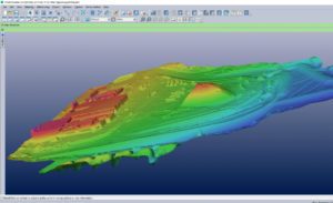
 Eos Systems recently released a photogrammetry software package created specifically for drones.
This past week, the Canadian firm announced the launch of PhotoModeler UAS 2016. The suite creates 3D imagery, maps and measurements from images transmitted via drone and integrates them with full geographic coordinate systems support.
“Photogrammetry has been our passion for over 20 years, and we are very excited by the response [PhotoModeler] has been getting from the drone market,” Eos CEO Alan Walford said in a recent DroneLife interview.
The company demonstrated the software at the 2016 Commercial UAV Expo in Las Vegas this past week. “We expect PhotoModeler UAS to play a key role in the rapidly growing UAS survey industry,” Walford said. Eos plans to offer the software at a reduced price of $2,275 through November.
PhotoModeler features post-processing kinematics (PPK), volume objects, full geographic coordinate systems support, multispectral image support and control point assistance.
“We can utilize a drone and fly a 43-acre site in minutes and PhotoModeler will take that data and provide the output we are looking for to effectively manage the project for our clients,” stated one Eos customer.
With post-processing kinematics, the software can correct a drone-driven survey mission with GPS data for greater accuracy which could prove powerful for precision industries such as agriculture, mining, construction and utility inspection surveys.
“Volume objects provide easy and accurate volume data for stock piles and mining operations. Full geographic coordinate system support enables users to work in their local geographic coordinate system for better compatibility,” Walford added.
“Support is provided for multispectral images including normalized difference vegetation index (NDVI) surface models and ortho-mosaics for precision agriculture. An intuitive interface is provided for efficiently marking ground control points.”
The marriage of surveying-drone technology and photogrammetry is expected to grow into a healthy trend-line in years to come. As a job-growth trend, photogrammetry came in 15th on a list of high-growth vocations, according to Bureau of Labor Statistics data. Photogrammetry jobs are expected to grow at a rate of 29 percent with a median salary of $60,930.
Jason is a longstanding contributor to DroneLife with an avid interest in all things tech. He focuses on anti-drone technologies and the public safety sector; police, fire, and search and rescue.
Beginning his career as a journalist in 1996, Jason has since written and edited thousands of engaging news articles, blog posts, press releases and online content.
Email Jason
TWITTER:@JasonPReagan
Subscribe to DroneLife here.


[…] post Eos Launches Photogrammetry Suite for Drones appeared first on […]