• Skip to main content
  • Skip to secondary menu
  • Skip to primary sidebar
  • Skip to secondary sidebar
  • Skip to footer
  • DroneRacingLife
  • DroneFlyers
  • Newsletter
DroneLife

DRONELIFE

Stay up to date on all the latest Drone News

  • News
  • Products
  • Industries
    • Agriculture
    • Construction
    • Delivery
    • Dual Use
    • Inspection
    • Public Safety
    • Surveying
  • Enthusiasts
  • Regulations
  • Business
  • Video
  • Podcasts

DARPA Works on Drone Dragnet

October 7, 2016 by Jason Reagan 4 Comments

Photo courtesy of DARPA

The U.S. military’s top think-tank is thinking of ways to map and track potentially harmful drones over major American cities.

Last month, the Defense Advanced Research Projects Agency announced the launch of the Aerial Dragnet program “to provide persistent, wide-area surveillance of all [drones] operating below 1,000 feet in a large city,” according to a DARPA statement.

“Commercial websites currently exist that display in real time the tracks of relatively high and fast aircraft—from small general aviation planes to large airliners—all overlaid on geographical maps as they fly around the country and the world,” DARPA program manager Jeff Krolik said in a press release.

“We want a similar capability for identifying and tracking slower, low-flying unmanned aerial systems, particularly in urban environments.”

The program’s primary focus is the protection of military troops in cities overseas; however, DARPA officials believe Aerial Dragnet could offer applications back home in mapping and tracking drone-inspired terror threats.

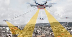
Researchers envision a surveillance network of overlapping sensor arrays spaced out over metropolitan neighborhoods.

“Although several systems are being developed for tracking small [drones] by extending surveillance methods used in open areas where large line-of-sight buffers mitigate the threat, these systems are impractical for operation in urban terrain,” Krolik said.

To fuel the program, DARPA is seeking a few good experts in sensor technology, signal processing and network autonomy to join Aerial Dragnet.

Once the right tech for the job is determined, DARPA hopes the system can be continually updated to provide a real-time, 3D overview of urban airspace that will identify what should and should not be up in the sky.

The mapping project will go hand-in-hand with DARPA’s other projects designed to mitigate rogue drone threats.  In August, the agency announced a request for information to help create “novel, flexible, mobile layered” anti-drone solutions to defend “fixed and mobile ground and naval forces from possible drone threats.”

When it comes to drone tech, however, DARPA is playing both sides of the street. Earlier this year, the agency tested three drones for its Fast Lightweight Autonomy program, launching sensor-heavy quadcopters that can fly autonomously up to 45 mph.

Officials hope the project can help “reduce the amount of processing power, communications, and human intervention needed for [drones] to accomplish low-level tasks, such as navigation around obstacles in a cluttered environment.”

Jason Reagan
Jason Reagan

Jason is a longstanding contributor to DroneLife with an avid interest in all things tech. He focuses on anti-drone technologies and the public safety sector; police, fire, and search and rescue.

Beginning his career as a journalist in 1996, Jason has since written and edited thousands of engaging news articles, blog posts, press releases and online content.

Email Jason
TWITTER:@JasonPReagan

LinkedIn 

Subscribe to DroneLife here.

Filed Under: Defense, Fire and Police, News Tagged With: Aerial Dragnet, Anti-drone, DARPA

Reader Interactions

Trackbacks

  1. DARPA Once Again Seeks New Ways to Defeat Rogue Drones | News and Reviews about Drones, Quadcopter, Camera says:
    September 28, 2017 at 11:16 am

    […] and mobile ground and naval forces from possible drone threats.” The agency also launched the Aerial Dragnet program “to provide persistent, wide-area surveillance of all [drones] operating below 1,000 feet […]

    Reply
  2. drone helicopter | DARPA Once Again Seeks New Ways to Defeat Rogue Drones says:
    September 28, 2017 at 11:05 am

    […] and mobile ground and naval forces from possible drone threats.” The agency also launched the Aerial Dragnet program “to provide persistent, wide-area surveillance of all [drones] operating below 1,000 feet […]

    Reply
  3. Orange Leaf Successfully Delivers Frozen Yogurt by Drone | Drone "Ki" says:
    November 7, 2016 at 12:00 am

    […] The U.S. military’s top think-tank is thinking of ways to map and track potentially harmful drones over major American cities. Last month, the Defense Advanced Research Projects Agency announced the launch of the Aerial Dragnet program “to provide persistent, wide-area surveillance of all [drones] operating below 1,000 feet in a large city,” according to a […] The post DARPA Works on Drone Dragnet appeared first on DRONELIFE. See Original Article […]

    Reply
  4. DARPA Works on Drone Dragnet | Drone, UAV, Quadcopter a Multi Rotor News says:
    October 7, 2016 at 3:45 pm

    […] post DARPA Works on Drone Dragnet appeared first on […]

    Reply

Leave a Reply Cancel reply

Your email address will not be published. Required fields are marked *

Primary Sidebar

LATEST

UK Government Backs Drone Expansion with £50 Million Investment

Windracers among companies recognized as UK moves to scale routine drone operations and advanced air mobility The UK government has…

Continue Reading UK Government Backs Drone Expansion with £50 Million Investment

U.S. Navy Awards Packet Digital $9.8 Million to Scale Drone Battery Production in North Dakota

North Dakota facility will manufacture NDAA-compliant battery cells for drones and defense systems Packet Digital and its subsidiary Badland Batteries…

Continue Reading U.S. Navy Awards Packet Digital $9.8 Million to Scale Drone Battery Production in North Dakota

Danish Startup Launches 10K Drone Sensor for Wide-Area Search, Surveillance, and Mine Detection

Danish start-up promotes innovative sensor system By DRONELIFE Features Editor Jim Magill Marine rescue teams using drones to search for…

Continue Reading Danish Startup Launches 10K Drone Sensor for Wide-Area Search, Surveillance, and Mine Detection

FAA Publishes Proposed Rule for Drone Restrictions Around Critical Infrastructure

New Section 2209 NPRM would create a formal process for restricting drone flights near sensitive facilities The Federal Aviation Administration…

Continue Reading FAA Publishes Proposed Rule for Drone Restrictions Around Critical Infrastructure

Public Comment Window Closing: FCC Weighs DJI Challenge to Covered List Ruling

Public input period highlights ongoing divide over foreign drone policy and market access The deadline to submit comments on the…

Continue Reading Public Comment Window Closing: FCC Weighs DJI Challenge to Covered List Ruling

FAA Advances Long-Delayed Rule to Restrict Drones Over Sensitive Sites

Long-awaited proposal aims to balance security and access in low-altitude airspace The Federal Aviation Administration (FAA) has announced a long-anticipated…

Continue Reading FAA Advances Long-Delayed Rule to Restrict Drones Over Sensitive Sites

WaiV Robotics Debuts Maritime VTOL Landing Pad with $7.5M Seed Round

The London-based maritime startup unveils a gyro-stabilized landing pad that recovers VTOL drones on vessels as small as 10 meters…

Continue Reading WaiV Robotics Debuts Maritime VTOL Landing Pad with $7.5M Seed Round

Perceptual Robotics Raises Funding to Automate Wind Turbine Inspection Drones

Loggerhead Ventures leads the round with follow-on from One Planet Capital, fueling AI-powered drones for wind farm maintenance. Perceptual Robotics…

Continue Reading Perceptual Robotics Raises Funding to Automate Wind Turbine Inspection Drones

Teledyne FLIR OEM Launches Prism Software to Detect Small Drones at Longer Range

New AI-enabled software aims to identify small drone threats earlier and support faster response Teledyne FLIR OEM, part of Teledyne…

Continue Reading Teledyne FLIR OEM Launches Prism Software to Detect Small Drones at Longer Range

When Commercial Drone Technology Meets Defense: A Closer Look at Civil–Military Integration

New analysis highlights how shared innovation pipelines are shaping both commercial drone markets and military capabilities A recent report from…

Continue Reading When Commercial Drone Technology Meets Defense: A Closer Look at Civil–Military Integration

Secondary Sidebar

Footer

SPONSORED

Inspired Flight Gremsy IF800 VIO F1 drones geo week

What Will It Take to Strengthen U.S. Drone Manufacturing? A Conversation with Inspired Flight’s CEO

Global Mapper Mobile data collection

Collection Ground Control Points with Global Mapper Mobile

Military Drone Mapping Solutions

How SimActive’s Correlator3D™ is Revolutionizing Military Mapping: An Exclusive Interview with CEO Philippe Simard

Photogrammetry Accuracy Standards

SimActive Photogrammetry Software: Enabling Users to Meet Accuracy Standards for Over 20 Years

NACT Engineering Parrot ANAFI tether indoor shot

Smart Tether for Parrot ANAFI USA from NACT Engineering

Blue Marble, features global mapper, features Blue Marble

Check Out These New Features in Global Mapper v25 from Blue Marble

About Us | Contact Us | Advertise With Us | Write for Us | Privacy Policy | Terms of Service

The Trusted Source for the Business of Drones.

This website uses cookies and third party services. By clicking OK, you are agreeing to our privacy policy. ACCEPT

Manage consent

Privacy Overview

This website uses cookies to improve your experience while you navigate through the website. Out of these, the cookies that are categorized as necessary are stored on your browser as they are essential for the working of basic functionalities of the website. We also use third-party cookies that help us analyze and understand how you use this website. These cookies will be stored in your browser only with your consent. You also have the option to opt-out of these cookies. But opting out of some of these cookies may affect your browsing experience.
Necessary
Always Enabled
Necessary cookies are absolutely essential for the website to function properly. These cookies ensure basic functionalities and security features of the website, anonymously.
CookieDurationDescription
cookielawinfo-checkbox-analytics11 monthsThis cookie is set by GDPR Cookie Consent plugin. The cookie is used to store the user consent for the cookies in the category "Analytics".
cookielawinfo-checkbox-functional11 monthsThe cookie is set by GDPR cookie consent to record the user consent for the cookies in the category "Functional".
cookielawinfo-checkbox-necessary11 monthsThis cookie is set by GDPR Cookie Consent plugin. The cookies is used to store the user consent for the cookies in the category "Necessary".
cookielawinfo-checkbox-others11 monthsThis cookie is set by GDPR Cookie Consent plugin. The cookie is used to store the user consent for the cookies in the category "Other.
cookielawinfo-checkbox-performance11 monthsThis cookie is set by GDPR Cookie Consent plugin. The cookie is used to store the user consent for the cookies in the category "Performance".
viewed_cookie_policy11 monthsThe cookie is set by the GDPR Cookie Consent plugin and is used to store whether or not user has consented to the use of cookies. It does not store any personal data.
Functional
Functional cookies help to perform certain functionalities like sharing the content of the website on social media platforms, collect feedbacks, and other third-party features.
Performance
Performance cookies are used to understand and analyze the key performance indexes of the website which helps in delivering a better user experience for the visitors.
Analytics
Analytical cookies are used to understand how visitors interact with the website. These cookies help provide information on metrics the number of visitors, bounce rate, traffic source, etc.
Advertisement
Advertisement cookies are used to provide visitors with relevant ads and marketing campaigns. These cookies track visitors across websites and collect information to provide customized ads.
Others
Other uncategorized cookies are those that are being analyzed and have not been classified into a category as yet.
SAVE & ACCEPT