• Skip to main content
  • Skip to secondary menu
  • Skip to primary sidebar
  • Skip to secondary sidebar
  • Skip to footer
  • DroneRacingLife
  • DroneFlyers
  • Newsletter
DroneLife

DRONELIFE

Stay up to date on all the latest Drone News

  • News
  • Products
  • Industries
    • Agriculture
    • Construction
    • Delivery
    • Dual Use
    • Inspection
    • Public Safety
    • Surveying
  • Enthusiasts
  • Regulations
  • Business
  • Video
  • Podcasts

Teledyne FLIR Defense Expands Payload Program with Emesent Hovermap for GPS-Denied Operations

April 28, 2026 by Miriam McNabb Leave a Comment

New integration brings LiDAR mapping and radiation detection together across air and ground platforms

Teledyne FLIR Defense has expanded its Third-Party Payload Integration Program with the addition of Emesent’s Hovermap LiDAR payload. Announced at Modern Day Marine 2026, the certification allows the Hovermap system to operate across Teledyne FLIR’s unmanned aerial systems (UAS), ground robots, and radiation detection platforms.

The integration focuses on a common operational challenge: environments where GPS signals are unavailable or unreliable. These conditions often occur in tunnels, dense urban areas, and hazardous CBRN (chemical, biological, radiological, and nuclear) environments. By combining LiDAR-based mapping with existing platforms, the companies aim to improve situational awareness without relying on external infrastructure.

Addressing GPS-Denied Environments

Emesent’s Hovermap uses LiDAR-based Simultaneous Localization and Mapping (SLAM) technology to generate accurate 3D maps without GPS. This capability allows operators to navigate and map complex environments in real time.

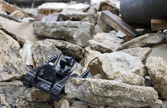
The system is now compatible with several Teledyne FLIR platforms. On the SkyRanger® R70 and R80D SkyRaider® drones, Hovermap enables aerial mapping in GPS-denied conditions. When mounted on the SUGV™ 325 ground robot, it provides continuous 3D awareness in enclosed or obstructed spaces.

The integration also extends to radiation detection. When paired with the MUVE™ R430 payload on the SUGV platform, Hovermap allows operators to visualize radiation levels within a mapped environment. This creates a combined spatial and hazard picture for CBRN teams operating in the field.

“Knowing the shape of a space is powerful. Knowing where the radiation is within that space, in real time, without putting a person in harm’s way, is an operational game-changer,” said Stefan Hrabar, co-founder and chief strategy officer at Emesent. “Our partnership with Teledyne FLIR Defense brings together GPS-denied mapping and radiation detection in a way that directly addresses what CBRN operators need in the field.”

Expanding Multi-Sensor Capabilities

Teledyne FLIR says the integration reflects a broader shift toward combining multiple sensing technologies into a single operational view. The company’s open-architecture approach allows third-party payloads to be certified for compatibility across its platforms.

“Teledyne FLIR builds platforms trusted for the most demanding CBRN missions in the world,” said Tung Ng, vice president of Unmanned Systems North America for Teledyne FLIR Defense. “Working with Emesent, we’ll be able to give operators a fused, spatial picture of the threat environment they simply haven’t had access to before.

“This is the direction the whole field is heading in, and we’re delivering it now through certified third-party payloads like Hovermap,” Ng added.

Certified payloads undergo testing for mechanical fit, electrical integration, software compatibility, and flight performance. This process is designed to ensure that new capabilities can be deployed reliably across existing systems.

Foundation for Future Development

Both companies indicate that the partnership will extend beyond current capabilities. Ongoing development efforts include autonomous navigation and expanded sensor fusion across additional CBRN detection technologies.

The integration highlights a growing focus on systems that combine mapping, detection, and real-time data into a single operational workflow. For public safety and defense users, this approach may reduce the need for multiple separate tools in complex environments.

The integrated systems are on display at Teledyne FLIR Defense booth #1724 at Modern Day Marine 2026, held April 28–30 at Marine Corps Base Quantico.

Read more:

  • Teledyne FLIR OEM Upgrades Prism SKR Software for Autonomous Target Recognition
  • Teledyne FLIR OEM Launches Lepton XDS Dual Thermal-Visible Camera Module
  • Teledyne FLIR OEM Introduces Its Longest-Range Thermal ISR Camera to Date
Miriam McNabb

Miriam McNabb is the Editor-in-Chief of DRONELIFE and CEO of JobForDrones, a professional drone services marketplace, and a fascinated observer of the emerging drone industry and the regulatory environment for drones. Miriam has penned over 3,000 articles focused on the commercial drone space and is an international speaker and recognized figure in the industry.  Miriam has a degree from the University of Chicago and over 20 years of experience in high tech sales and marketing for new technologies.
For drone industry consulting or writing, Email Miriam.

TWITTER:@spaldingbarker

Subscribe to DroneLife here.

Filed Under: Applications, Defense, Drone News, Drone News Feeds, Dual Use, LiDAR, News Tagged With: CBRN detection, defense technology, drone payload integration, Emesent Hovermap, GPS-denied navigation, ground robots, LiDAR drones, Public Safety Drones, radiation mapping, SkyRaider R80D, SkyRanger R70, SLAM mapping, SUGV 325, Teledyne FLIR Defense, unmanned systems

Reader Interactions

Leave a Reply Cancel reply

Your email address will not be published. Required fields are marked *

Primary Sidebar

LATEST

Who Builds the Sky? How Regional Partnerships Are Creating the Infrastructure for Advanced Air Mobility

On this episode of the Drone Radio Show, Lavera Alexander of the Monterey Bay Economic Partnership discusses why the future…

Continue Reading Who Builds the Sky? How Regional Partnerships Are Creating the Infrastructure for Advanced Air Mobility

FAA Moves from Planning to Building for Advanced Air Mobility

New research facility signals shift from policy development to operational readiness The Federal Aviation Administration is taking another step toward…

Continue Reading FAA Moves from Planning to Building for Advanced Air Mobility

How Skyways Quietly Built a Global Heavy-Lift Drone Business

Texas-based company expands offshore cargo operations while preparing for the next phase of U.S. BVLOS regulations By DRONELIFE Features Editor…

Continue Reading How Skyways Quietly Built a Global Heavy-Lift Drone Business

National Resilience Strategy Connects the Dots Behind U.S. Drone Policy

New White House strategy frames commercial drones as part of a broader effort to strengthen U.S. manufacturing, infrastructure, and supply…

Continue Reading National Resilience Strategy Connects the Dots Behind U.S. Drone Policy

Beyond the Drone: Percepto’s New Platform Brings AI to Infrastructure Inspections

Percepto launches next-gen inspection software By DRONELIFE Features Editor Jim Magill For energy companies, producing actionable data is almost as…

Continue Reading Beyond the Drone: Percepto’s New Platform Brings AI to Infrastructure Inspections

Danish Investigation Finds No Proof Drones Caused Copenhagen Airport Shutdown

Nine-month investigation underscores the need for better airspace awareness, not just more speculation News and Commentary.  A nine-month investigation into…

Continue Reading Danish Investigation Finds No Proof Drones Caused Copenhagen Airport Shutdown

Flytrex and Wing Report Zero Airspace Conflicts for Multi-Operator Drone Delivery

Flytrex says automated UTM coordination with Wing has deconflicted 100% of operations in Dallas–Fort Worth shared airspace, with zero conflicts.…

Continue Reading Flytrex and Wing Report Zero Airspace Conflicts for Multi-Operator Drone Delivery

BRINC Partnership Gives Public Safety Agencies an “Immediate Upgrade” in Incident Intelligence

BRINC and Nova Partner to Add Advanced Mapping and Thermal Intelligence for Public Safet Public safety drone manufacturer BRINC has…

Continue Reading BRINC Partnership Gives Public Safety Agencies an “Immediate Upgrade” in Incident Intelligence

Prodrone Debuts All-Japanese Industrial Drone

This article published in collaboration with JUIDA, the Japan UAS Industrial Development Association.     Aichi-based Prodrone introduces the PD4B-MS prototype,…

Continue Reading Prodrone Debuts All-Japanese Industrial Drone

Uruguayan Government Announces New Drone Dispatch Program

The Montevideo deployment, run in partnership with Uruguayan technology firm Timerix, ties gunshot-detection alerts to automated drone dispatch and live…

Continue Reading Uruguayan Government Announces New Drone Dispatch Program

Secondary Sidebar

Footer

SPONSORED

Inspired Flight Gremsy IF800 VIO F1 drones geo week

What Will It Take to Strengthen U.S. Drone Manufacturing? A Conversation with Inspired Flight’s CEO

Global Mapper Mobile data collection

Collection Ground Control Points with Global Mapper Mobile

Military Drone Mapping Solutions

How SimActive’s Correlator3D™ is Revolutionizing Military Mapping: An Exclusive Interview with CEO Philippe Simard

Photogrammetry Accuracy Standards

SimActive Photogrammetry Software: Enabling Users to Meet Accuracy Standards for Over 20 Years

NACT Engineering Parrot ANAFI tether indoor shot

Smart Tether for Parrot ANAFI USA from NACT Engineering

Blue Marble, features global mapper, features Blue Marble

Check Out These New Features in Global Mapper v25 from Blue Marble

About Us | Contact Us | Advertise With Us | Write for Us | Privacy Policy | Terms of Service

The Trusted Source for the Business of Drones.

This website uses cookies and third party services. By clicking OK, you are agreeing to our privacy policy. ACCEPT

Manage consent

Privacy Overview

This website uses cookies to improve your experience while you navigate through the website. Out of these, the cookies that are categorized as necessary are stored on your browser as they are essential for the working of basic functionalities of the website. We also use third-party cookies that help us analyze and understand how you use this website. These cookies will be stored in your browser only with your consent. You also have the option to opt-out of these cookies. But opting out of some of these cookies may affect your browsing experience.
Necessary
Always Enabled
Necessary cookies are absolutely essential for the website to function properly. These cookies ensure basic functionalities and security features of the website, anonymously.
CookieDurationDescription
cookielawinfo-checkbox-analytics11 monthsThis cookie is set by GDPR Cookie Consent plugin. The cookie is used to store the user consent for the cookies in the category "Analytics".
cookielawinfo-checkbox-functional11 monthsThe cookie is set by GDPR cookie consent to record the user consent for the cookies in the category "Functional".
cookielawinfo-checkbox-necessary11 monthsThis cookie is set by GDPR Cookie Consent plugin. The cookies is used to store the user consent for the cookies in the category "Necessary".
cookielawinfo-checkbox-others11 monthsThis cookie is set by GDPR Cookie Consent plugin. The cookie is used to store the user consent for the cookies in the category "Other.
cookielawinfo-checkbox-performance11 monthsThis cookie is set by GDPR Cookie Consent plugin. The cookie is used to store the user consent for the cookies in the category "Performance".
viewed_cookie_policy11 monthsThe cookie is set by the GDPR Cookie Consent plugin and is used to store whether or not user has consented to the use of cookies. It does not store any personal data.
Functional
Functional cookies help to perform certain functionalities like sharing the content of the website on social media platforms, collect feedbacks, and other third-party features.
Performance
Performance cookies are used to understand and analyze the key performance indexes of the website which helps in delivering a better user experience for the visitors.
Analytics
Analytical cookies are used to understand how visitors interact with the website. These cookies help provide information on metrics the number of visitors, bounce rate, traffic source, etc.
Advertisement
Advertisement cookies are used to provide visitors with relevant ads and marketing campaigns. These cookies track visitors across websites and collect information to provide customized ads.
Others
Other uncategorized cookies are those that are being analyzed and have not been classified into a category as yet.
SAVE & ACCEPT