
• Skip to main content
  • Skip to secondary menu
  • Skip to primary sidebar
  • Skip to secondary sidebar
  • Skip to footer
  • DroneRacingLife
  • DroneFlyers
  • Newsletter
DroneLife

DRONELIFE

Stay up to date on all the latest Drone News

  • News
  • Products
  • Industries
    • Agriculture
    • Construction
    • Delivery
    • Dual Use
    • Inspection
    • Public Safety
    • Surveying
  • Enthusiasts
  • Regulations
  • Business
  • Video
  • Podcasts

GeoCue Launches TrueView 550 Aerial LiDAR System at INTERGEO

September 16, 2026 by Miriam McNabb Leave a Comment

New system combines advanced LiDAR, dual mapping cameras and two positioning options for professional surveying and mapping.

GeoCue has expanded its standard aerial LiDAR portfolio with the launch of the TrueView 550. The company announced the new mapping system at INTERGEO 2026 in Munich, Germany.

The TrueView 550 builds on GeoCue’s TrueView 539 and TrueView 540 systems. It combines high-performance LiDAR with two 20-megapixel mapping cameras. Customers can also choose between two GNSS-inertial navigation systems.
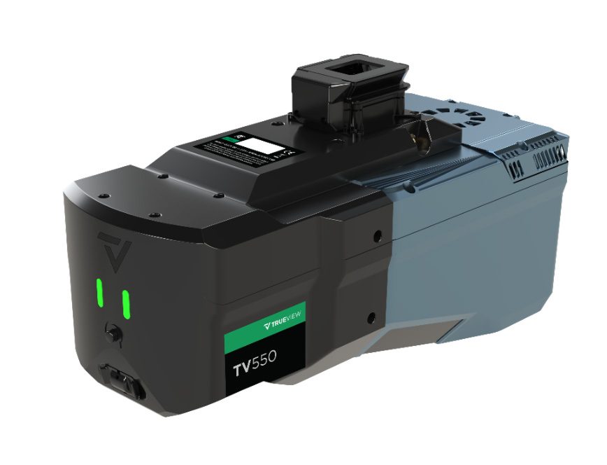
GeoCue designed the system for surveying, engineering and other geospatial applications. It aims to offer performance close to higher-end aerial LiDAR systems at a lower price point.

Longer Range and Higher Data Density

The TrueView 550 supports ranging distances of up to 2,100 meters. Typical flight altitudes range from 100 to 600 meters above ground level.

At 120 meters, the scanner can collect up to one million points per second. Advanced waveform processing supports point-cloud density and data completeness. These capabilities can help operators map larger areas and work over steep or uneven terrain.

“The TrueView 550 is a true GeoCue product made in USA,” said Frank Darmayan, CEO of GeoCue. “We are combining the latest advanced LiDAR technology, GNSS-INS, and dual mapping cameras for a wider Field of View. The result is a completely unique TrueView sensor that gives customers the level of accuracy and performance they expect from an engineering-grade system, but at a much more accessible price point.”

The system includes two 20-megapixel global shutter cameras. Together, they provide a wider imaging field of view than a single-camera system.

The cameras collect RGB imagery while the LiDAR sensor records 3D measurements. This combined data can improve point-cloud colorization and help users identify features. It can also support inspections and the creation of project deliverables.

Potential uses include topographic surveys, infrastructure mapping, corridor projects and construction documentation. The system also connects with GeoCue’s broader workflow. Users can process data, perform quality control and create deliverables in LP360.

Two Positioning Options

GeoCue offers the TrueView 550 with its TrueNav GNSS-inertial navigation system. Customers can also select the Applanix APX-20 for higher positioning performance.

The APX-20 option includes unlimited Trimble PP-RTX post-processing. PP-RTX uses satellite and reference network corrections to provide centimeter-level positioning. This approach can remove the need to establish a field base station.

“The LiDAR market continues to evolve, and our customers have different requirements depending on the projects they are taking on,” said Vivien Heriard-Dubreuil, CEO of mdGroup, GeoCue’s parent company. “With the TrueView 550, we wanted to give customers more choice. They can select our TrueNav positioning system for a powerful, integrated GeoCue solution, or choose the Applanix APX-20 for enhanced GNSS-inertial performance and access to unlimited PP-RTX processing. That flexibility, combined with the performance of the new LiDAR and dual imaging system, makes the TrueView 550 the highest-performing sensor in our standard portfolio.”

Expanding the TrueView Portfolio

The INTERGEO launch follows two GeoCue product announcements at Commercial UAV Expo 2026. At that event, the company introduced the TV1 NDAA UL and TV1 NDAA.

GeoCue developed both systems with Ouster. They use the Ouster OS1 MAX REV8, a 256-channel LiDAR sensor. It can collect up to 10.4 million points per second. Its practical detection range reaches 200 meters at 10% reflectivity.

The lightweight TV1 NDAA UL uses the sensor’s native direct colorization. As a result, it does not need a separate mapping camera to colorize the point cloud. Its size and weight make it suitable for compact multirotor and fixed-wing aircraft.

The TV1 NDAA uses the same LiDAR technology but adds a 26-megapixel global shutter camera. It collects detailed point clouds and high-resolution images during the same flight.

These systems address customers with NDAA compliance requirements. The TrueView 550 serves customers seeking a high-performance option within GeoCue’s standard product range.

“We look for gaps and opportunities where we can better fulfill the needs of our customers and respond to what the market is asking for,” said Vincent Legrand, Vice President of Global Sales at GeoCue. “The TrueView 550 fills an important position in our standard range, just as the new TV1 NDAA systems expanded our compliant range. Having strong options across both our Standard and NDAA-compliant portfolios gives GeoCue the ability to help customers select the right tool for the work they actually need to accomplish.”

Read more:

  • GeoCue Integrates Ouster’s BABA-Compliant Rev8 OS1 Max Lidar Into TrueView Drone Payloads
  • GeoCue’s TrueView 641 Certified for Real-Time Robotics HERA Drone
  • GeoCue Partners with JGC Geoinformation Systems to Expand LiDAR Mapping Solutions in Greece and Balkans

 

Miriam McNabb

Miriam McNabb is the Editor-in-Chief of DRONELIFE and CEO of JobForDrones, a professional drone services marketplace, and a fascinated observer of the emerging drone industry and the regulatory environment for drones. Miriam has penned over 3,000 articles focused on the commercial drone space and is an international speaker and recognized figure in the industry.  Miriam has a degree from the University of Chicago and over 20 years of experience in high tech sales and marketing for new technologies.
For drone industry consulting or writing, Email Miriam.

TWITTER:@spaldingbarker

Subscribe to DroneLife here.

Filed Under: Applications, Cameras, Construction, Drone News, Drone News Feeds, Mapping, News Tagged With: aerial LiDAR, Applanix, drone surveying, GeoCue, geospatial technology, high-performance drone LiDAR, INTERGEO 2026, LiDAR mapping, LP360, TrueView 550

Reader Interactions

Leave a Reply Cancel reply

Your email address will not be published. Required fields are marked *

Primary Sidebar

LATEST

FAA Part 107 Drone Pilot Test Changes October 26: What Applicants Need to Know

New image-based questions will require applicants to interpret aviation charts, while existing Part 107 regulations remain unchanged. The Federal Aviation…

Continue Reading FAA Part 107 Drone Pilot Test Changes October 26: What Applicants Need to Know

DroneClear Launches ChatGPT App to Help Travelers Navigate Thailand’s Drone Rules

AI-powered service provides information on drone registration, insurance, and flight restrictions. DroneClear Thailand has introduced a ChatGPT app designed to…

Continue Reading DroneClear Launches ChatGPT App to Help Travelers Navigate Thailand’s Drone Rules

Do Cleaning Drones Actually Work? 15 Apellix Before-and-After Jobs Show the Results

Cleaning drones offer a commercial use case providing one of the clearest examples of drones handling the “dark, dirty, and…

Continue Reading Do Cleaning Drones Actually Work? 15 Apellix Before-and-After Jobs Show the Results

29 Governors Call for Expanded Counter-Drone Training Under New Federal Law

Bipartisan request seeks more training for law enforcement, corrections officers, and National Guard personnel as states implement new counter-UAS authorities.…

Continue Reading 29 Governors Call for Expanded Counter-Drone Training Under New Federal Law

Cleaning, Painting, and Beyond: Lucid Bots Expands Its Drone Platform

Student’s vision turns into drone cleaning startup By DRONELIFE Features Editor Jim Magill The inspiration needed to start a successful…

Continue Reading Cleaning, Painting, and Beyond: Lucid Bots Expands Its Drone Platform

“Hammer Down”: FCC Moves to Open 50 MHz of Spectrum for Drones

October 29 vote will also consider new restrictions on foreign electronics testing and certification laboratories. The Federal Communications Commission (FCC)…

Continue Reading “Hammer Down”: FCC Moves to Open 50 MHz of Spectrum for Drones

WarrenUAS Hosts Second Tactical Drone Training Course for Regional First Responders

Following a July session for police, fire and water rescue teams from New Jersey and Pennsylvania, the November 21 course…

Continue Reading WarrenUAS Hosts Second Tactical Drone Training Course for Regional First Responders

Ørsted and Skyports Trial Heavy Cargo Drones for Turbine Maintenance at Hornsea 2

The four-week North Sea trial flew maintenance kits weighing up to 65 kilograms (143 pounds) between a service vessel and…

Continue Reading Ørsted and Skyports Trial Heavy Cargo Drones for Turbine Maintenance at Hornsea 2

Court Challenge Could Shape FCC Authority Over Previously Approved Drones

Hikvision challenge comes as FCC considers restrictions on previously authorized foreign-produced drones A case argued before the U.S. Court of…

Continue Reading Court Challenge Could Shape FCC Authority Over Previously Approved Drones

Satellite Applications Catapult Announces National Drone Testing Center at Westcott

The National Autonomy and Drone Innovation Centre, backed by £2.25 million (about $3 million) from Buckinghamshire Council, will give UK…

Continue Reading Satellite Applications Catapult Announces National Drone Testing Center at Westcott

Secondary Sidebar

Footer

SPONSORED

drone cleaning

Do Cleaning Drones Actually Work? 15 Apellix Before-and-After Jobs Show the Results

What Is the Best Commercial Cleaning Drone in 2026? Specs, Prices, and a Head-to-Head Comparison

Inspired Flight Gremsy IF800 VIO F1 drones geo week

What Will It Take to Strengthen U.S. Drone Manufacturing? A Conversation with Inspired Flight’s CEO

Global Mapper Mobile data collection

Collection Ground Control Points with Global Mapper Mobile

Military Drone Mapping Solutions

How SimActive’s Correlator3D™ is Revolutionizing Military Mapping: An Exclusive Interview with CEO Philippe Simard

Photogrammetry Accuracy Standards

SimActive Photogrammetry Software: Enabling Users to Meet Accuracy Standards for Over 20 Years

About Us | Contact Us | Advertise With Us | Write for Us | Privacy Policy | Terms of Service

The Trusted Source for the Business of Drones.

This website uses cookies and third party services. By clicking OK, you are agreeing to our privacy policy. ACCEPT

Manage consent

Privacy Overview

This website uses cookies to improve your experience while you navigate through the website. Out of these, the cookies that are categorized as necessary are stored on your browser as they are essential for the working of basic functionalities of the website. We also use third-party cookies that help us analyze and understand how you use this website. These cookies will be stored in your browser only with your consent. You also have the option to opt-out of these cookies. But opting out of some of these cookies may affect your browsing experience.
Necessary
Always Enabled
Necessary cookies are absolutely essential for the website to function properly. These cookies ensure basic functionalities and security features of the website, anonymously.
CookieDurationDescription
cookielawinfo-checkbox-analytics11 monthsThis cookie is set by GDPR Cookie Consent plugin. The cookie is used to store the user consent for the cookies in the category "Analytics".
cookielawinfo-checkbox-functional11 monthsThe cookie is set by GDPR cookie consent to record the user consent for the cookies in the category "Functional".
cookielawinfo-checkbox-necessary11 monthsThis cookie is set by GDPR Cookie Consent plugin. The cookies is used to store the user consent for the cookies in the category "Necessary".
cookielawinfo-checkbox-others11 monthsThis cookie is set by GDPR Cookie Consent plugin. The cookie is used to store the user consent for the cookies in the category "Other.
cookielawinfo-checkbox-performance11 monthsThis cookie is set by GDPR Cookie Consent plugin. The cookie is used to store the user consent for the cookies in the category "Performance".
viewed_cookie_policy11 monthsThe cookie is set by the GDPR Cookie Consent plugin and is used to store whether or not user has consented to the use of cookies. It does not store any personal data.
Functional
Functional cookies help to perform certain functionalities like sharing the content of the website on social media platforms, collect feedbacks, and other third-party features.
Performance
Performance cookies are used to understand and analyze the key performance indexes of the website which helps in delivering a better user experience for the visitors.
Analytics
Analytical cookies are used to understand how visitors interact with the website. These cookies help provide information on metrics the number of visitors, bounce rate, traffic source, etc.
Advertisement
Advertisement cookies are used to provide visitors with relevant ads and marketing campaigns. These cookies track visitors across websites and collect information to provide customized ads.
Others
Other uncategorized cookies are those that are being analyzed and have not been classified into a category as yet.
SAVE & ACCEPT




