
• Skip to main content
  • Skip to secondary menu
  • Skip to primary sidebar
  • Skip to secondary sidebar
  • Skip to footer
  • DroneRacingLife
  • DroneFlyers
  • Newsletter
DroneLife

DRONELIFE

Stay up to date on all the latest Drone News

  • News
  • Products
  • Industries
    • Agriculture
    • Construction
    • Delivery
    • Dual Use
    • Inspection
    • Public Safety
    • Surveying
  • Enthusiasts
  • Regulations
  • Business
  • Video
  • Podcasts

Alaskan Drone Team Enters Active Volcano to Advance Safer Research Methods

April 14, 2025 by Miriam McNabb Leave a Comment

University of Alaska Fairbanks mission tests remote gas sampling system at Costa Rica’s Poás volcano

In early March, a team from the University of Alaska Fairbanks (UAF) used drones to collect gas samples from the crater of Poás volcano in Costa Rica. Their mission, led by research assistant professor Társilo Girona, aimed to make volcano research safer by testing a new method of soil gas measurement using unmanned aircraft.
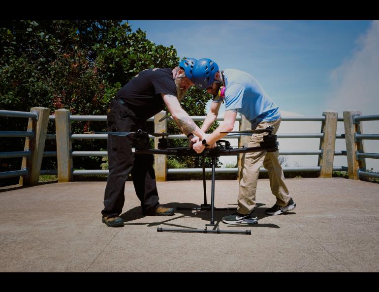
ACUASI Pilots work with Alta X drone: image credit Martina Picciallo

“Our goal was to test a new and safer way of measuring soil degassing at a variety of spots in an active volcanic crater, and we accomplished that goal,” Girona said. “The UAF drone team was fantastic, and the equipment performed exceptionally well.”

The drone-based approach allowed researchers to collect data from a volcanic crater about half a mile wide and 1,000 feet deep—one of the largest on Earth—without exposing personnel to dangerous conditions.

Part of a Larger International Effort

The UAF mission was part of a broader international experiment focused on understanding the plumbing system of Poás volcano. Now in its second year, the Poás community experiment began during the 12th Cities on Volcanoes Congress held in Guatemala and is supported by the AVERT (Anticipating Volcanic Eruptions in Real-Time) project in collaboration with Costa Rica’s Volcanological and Seismological Observatory (Oviscori).

Poás is one of Costa Rica’s most active and accessible volcanoes, standing 8,848 feet above sea level and located about 25 miles from the capital, San José. It has seen increased seismic activity and sulfur dioxide emissions, along with ground uplift. A steam-driven eruption on March 1 released an ash column as high as 1,300 feet, followed by additional eruptions.

“The challenge with phreatic explosions lies in their sudden occurrence, with little to no warning,” Girona said. “I hope using drones to measure soil degassing and soil conditions can help us to better anticipate these events.”

Innovative Use of Drone Technology

The Alaska Center for Unmanned Aircraft Systems Integration (ACUASI) provided the team and equipment for the drone volcano mission. This marked the group’s first drone flight into an active volcanic crater. Team members included drone pilots Jason Williams, Matthew Westhoff, and James Copple, alongside Girona.

The crew worked from a safe viewing platform located about one-third of a mile from the crater. They deployed two drones: a small Parrot drone to scout a safe landing area and a 24-pound Alta X Heavy Lift drone to carry the scientific instruments.
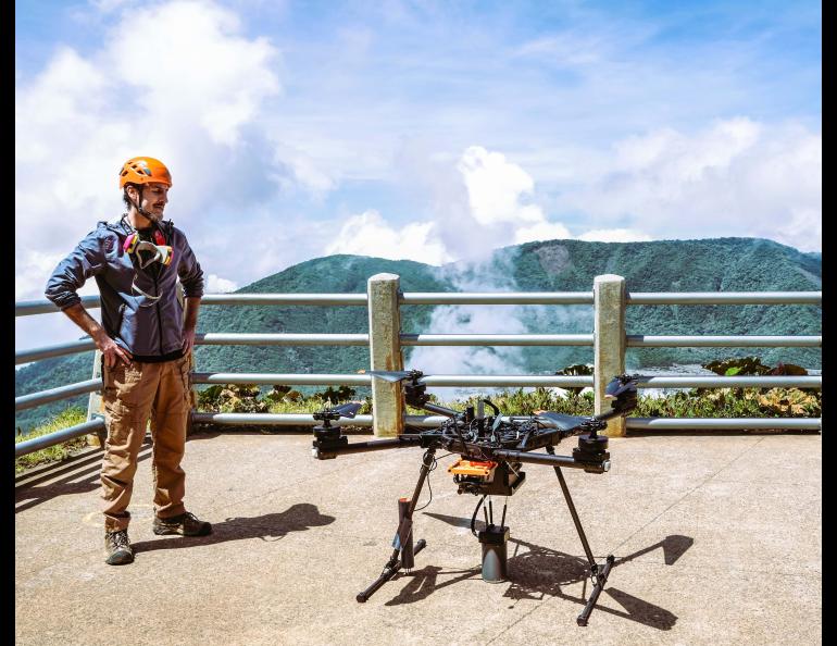
image credit Martina Picciallo

The Parrot drone remained airborne to monitor activity while the Alta X approached the landing site. The Alta X carried a gas accumulation chamber, gas sensor, and soil sensor. It landed, powered down its rotors, and pressed the chamber into the soil to collect samples for about two minutes before moving on to the next site.

“The aircraft performed extremely well in the challenging environment of the volcano,” said Williams, ACUASI’s chief unmanned aircraft systems pilot.

“There were some challenges to overcome, mainly the difficulty in determining the height of the instrumented aircraft from the ground while performing the landing and the exact lateral position in relation to the desired landing spot,” he added.

Coordination was essential, as a third drone operated by Copple provided real-time altitude data to guide the Alta X pilot during landing.

“There was an enormous amount of crew coordination by all three pilots while attempting to land the instrumented drone in the crater,” Williams said. “Since all three aircraft were airborne and in close proximity to each other, we were constantly informing each other of our height and position.”

Promising Results and Next Steps

The team collected data on carbon dioxide, water vapor, soil temperature, and moisture—key indicators of magma and hydrothermal activity. Girona said the mission proved that drones can conduct remote soil degassing campaigns safely and efficiently.

“It demonstrates the feasibility of using our approach for remote soil degassing measurements in challenging environments,” Girona said. “The mission not only confirmed the viability of the technique but also provided critical experience that will enhance future deployments in similar volcanic environments.”
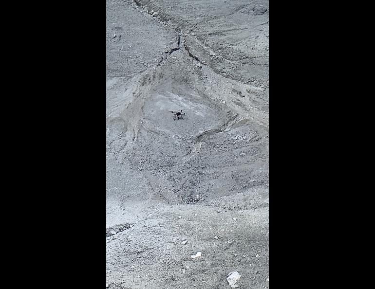
drone volcano mission UAF
AltaX Drone in crater, early March. Image courtesy ACUASI

Looking ahead, Girona hopes to secure additional funding to improve the method, expand to new volcanoes, and integrate more advanced technologies.

“With additional funding, we plan to refine and optimize our approach, expand fieldwork to different volcanic environments, and integrate advanced technologies to enhance measurement capabilities,” he said.

Girona plans to publish results from the Poás volcano campaign, further contributing to the growing body of research in safe, remote volcanology.  Learn more about the mission here!

Read more:

  • Drone Cargo Delivery: University of Alaska to Build New Hangar for Base of Operations
  • A 45 Mile, Airport-to-Airport Drone Delivery in Alaska
  • UAF Unveils New Icing Tower to Enhance Drone Safety in Arctic Conditions

Miriam McNabb

Miriam McNabb is the Editor-in-Chief of DRONELIFE and CEO of JobForDrones, a professional drone services marketplace, and a fascinated observer of the emerging drone industry and the regulatory environment for drones. Miriam has penned over 3,000 articles focused on the commercial drone space and is an international speaker and recognized figure in the industry.  Miriam has a degree from the University of Chicago and over 20 years of experience in high tech sales and marketing for new technologies.
For drone industry consulting or writing, Email Miriam.

TWITTER:@spaldingbarker

Subscribe to DroneLife here.

Filed Under: Drone News, Drone News Feeds, Drones in the News, News Tagged With: ACUASI, Costa Rica volcano, drone gas sampling, drone volcanology, phreatic eruption, Poás volcano, soil degassing, UAF drones, unmanned aircraft, volcano research

Reader Interactions

Leave a Reply Cancel reply

Your email address will not be published. Required fields are marked *

Primary Sidebar

LATEST

Beyond Part 108: FAA and EASA See Collaboration as Key to Scaling BVLOS

Despite different regulatory frameworks, aviation officials at Commercial UAV Expo pointed to common challenges in risk, data and managing increasingly…

Continue Reading Beyond Part 108: FAA and EASA See Collaboration as Key to Scaling BVLOS

GeoCue Integrates Ouster’s BABA-Compliant Rev8 OS1 Max Lidar Into TrueView Drone Payloads

Native color digital lidar joins TrueView 1 payloads and LP360 software for utility corridor and large-scale infrastructure mapping across the…

Continue Reading GeoCue Integrates Ouster’s BABA-Compliant Rev8 OS1 Max Lidar Into TrueView Drone Payloads

EagleNXT Launches Altum-PT Pro Sensor at Commercial UAV Expo

The new flagship of the MicaSense portfolio captures synchronized multispectral, panchromatic and radiometric thermal data in a single payload for…

Continue Reading EagleNXT Launches Altum-PT Pro Sensor at Commercial UAV Expo

Scaling Drone Operations Will Require More Than Part 108

FAA officials at Commercial UAV Expo discussed how regulation, information sharing, airspace modernization and security must work together as advanced…

Continue Reading Scaling Drone Operations Will Require More Than Part 108

Venezuela Earthquakes Show the Power of Drones, and the Challenge of a Crowded Sky

At Commercial UAV Expo, Juan Plaza outlined how drones supported rescue, damage assessment and recovery after the June earthquakes, while…

Continue Reading Venezuela Earthquakes Show the Power of Drones, and the Challenge of a Crowded Sky

California Passes 400-Foot Drone Restriction for Concerts, Raising FAA Pre-Emption Questions

AB 2113 would restrict unauthorized drone flights near large outdoor entertainment venues, but aviation attorneys say questions remain over state…

Continue Reading California Passes 400-Foot Drone Restriction for Concerts, Raising FAA Pre-Emption Questions

Heven AeroTech Stands Up Hydrogen Drone Factory in 90 Days

New 56,000-square-foot Virginia facility launches a planned nationwide UAS manufacturing networ Heven AeroTech has opened a 56,000-square-foot production facility in…

Continue Reading Heven AeroTech Stands Up Hydrogen Drone Factory in 90 Days

Amprius Targets Longer Drone Flights With New 500 Wh/kg Battery Cell

Second-generation SiCore technology pairs higher energy density with a path to volume productio Amprius Technologies has introduced a silicon-anode battery…

Continue Reading Amprius Targets Longer Drone Flights With New 500 Wh/kg Battery Cell

One Airspace View: Dronetag Remote ID Data Joins Airwise Nexus

The integration combines Remote ID detections with telemetry, radar, weather, and other operational dat Dronetag and Airwise Solutions have announced…

Continue Reading One Airspace View: Dronetag Remote ID Data Joins Airwise Nexus

Avidrone Pushes Heavy-Lift Drone Performance Toward the 4:1 Barrier

DARPA Lift Challenge winner achieves a 3.84:1 payload-to-weight ratio with a purpose-built 29-pound aircraft By DRONELIFE Features Editor Jim Magill…

Continue Reading Avidrone Pushes Heavy-Lift Drone Performance Toward the 4:1 Barrier

Secondary Sidebar

Footer

SPONSORED

What Is the Best Commercial Cleaning Drone in 2026? Specs, Prices, and a Head-to-Head Comparison

Inspired Flight Gremsy IF800 VIO F1 drones geo week

What Will It Take to Strengthen U.S. Drone Manufacturing? A Conversation with Inspired Flight’s CEO

Global Mapper Mobile data collection

Collection Ground Control Points with Global Mapper Mobile

Military Drone Mapping Solutions

How SimActive’s Correlator3D™ is Revolutionizing Military Mapping: An Exclusive Interview with CEO Philippe Simard

Photogrammetry Accuracy Standards

SimActive Photogrammetry Software: Enabling Users to Meet Accuracy Standards for Over 20 Years

NACT Engineering Parrot ANAFI tether indoor shot

Smart Tether for Parrot ANAFI USA from NACT Engineering

About Us | Contact Us | Advertise With Us | Write for Us | Privacy Policy | Terms of Service

The Trusted Source for the Business of Drones.

This website uses cookies and third party services. By clicking OK, you are agreeing to our privacy policy. ACCEPT

Manage consent

Privacy Overview

This website uses cookies to improve your experience while you navigate through the website. Out of these, the cookies that are categorized as necessary are stored on your browser as they are essential for the working of basic functionalities of the website. We also use third-party cookies that help us analyze and understand how you use this website. These cookies will be stored in your browser only with your consent. You also have the option to opt-out of these cookies. But opting out of some of these cookies may affect your browsing experience.
Necessary
Always Enabled
Necessary cookies are absolutely essential for the website to function properly. These cookies ensure basic functionalities and security features of the website, anonymously.
CookieDurationDescription
cookielawinfo-checkbox-analytics11 monthsThis cookie is set by GDPR Cookie Consent plugin. The cookie is used to store the user consent for the cookies in the category "Analytics".
cookielawinfo-checkbox-functional11 monthsThe cookie is set by GDPR cookie consent to record the user consent for the cookies in the category "Functional".
cookielawinfo-checkbox-necessary11 monthsThis cookie is set by GDPR Cookie Consent plugin. The cookies is used to store the user consent for the cookies in the category "Necessary".
cookielawinfo-checkbox-others11 monthsThis cookie is set by GDPR Cookie Consent plugin. The cookie is used to store the user consent for the cookies in the category "Other.
cookielawinfo-checkbox-performance11 monthsThis cookie is set by GDPR Cookie Consent plugin. The cookie is used to store the user consent for the cookies in the category "Performance".
viewed_cookie_policy11 monthsThe cookie is set by the GDPR Cookie Consent plugin and is used to store whether or not user has consented to the use of cookies. It does not store any personal data.
Functional
Functional cookies help to perform certain functionalities like sharing the content of the website on social media platforms, collect feedbacks, and other third-party features.
Performance
Performance cookies are used to understand and analyze the key performance indexes of the website which helps in delivering a better user experience for the visitors.
Analytics
Analytical cookies are used to understand how visitors interact with the website. These cookies help provide information on metrics the number of visitors, bounce rate, traffic source, etc.
Advertisement
Advertisement cookies are used to provide visitors with relevant ads and marketing campaigns. These cookies track visitors across websites and collect information to provide customized ads.
Others
Other uncategorized cookies are those that are being analyzed and have not been classified into a category as yet.
SAVE & ACCEPT




