
• Skip to main content
  • Skip to secondary menu
  • Skip to primary sidebar
  • Skip to secondary sidebar
  • Skip to footer
  • DroneRacingLife
  • DroneFlyers
  • Newsletter
DroneLife

DRONELIFE

Stay up to date on all the latest Drone News

  • News
  • Products
  • Industries
    • Agriculture
    • Construction
    • Delivery
    • Dual Use
    • Inspection
    • Public Safety
    • Surveying
  • Enthusiasts
  • Regulations
  • Business
  • Video
  • Podcasts

MassDOT Aeronautics Teams Up with MassDOT Highway to Pioneer Drone Technology for Smarter Highway Maintenance

August 4, 2024 by Miriam McNabb Leave a Comment

Drones and Data Analytics Set to Transform Highway Inspections in Massachusetts

The Massachusetts Department of Transportation (MassDOT) Aeronautics Division is teaming up with MassDOT Highway to take highway inspections and maintenance to the next level using drones and data analytics. They’ve applied for a $1 million grant from the Federal Highway Administration’s Accelerated Innovation Deployment (AID) Program to fund the second phase of this innovative project.

Building on Initial Success

The project’s first phase, backed by a $1 million AID grant in 2021 and an additional $250,000 from MassDOT, laid the groundwork for using drones in highway inspections. Dr. Sinan Abood, MassDOT Aeronautics Data & Analytics Team Leader, said, “The initial phase set up a digital system to manage and deliver UAS imagery and products.” This phase proved that drones could significantly enhance inspection accuracy and efficiency.

Drones provided high-resolution imagery and detailed 3D maps, making infrastructure assessments more precise. They also cut down on inspection times and costs while improving safety by enabling remote evaluations. Specific successes included faster bridge inspections, accurate pavement monitoring, and better environmental management.
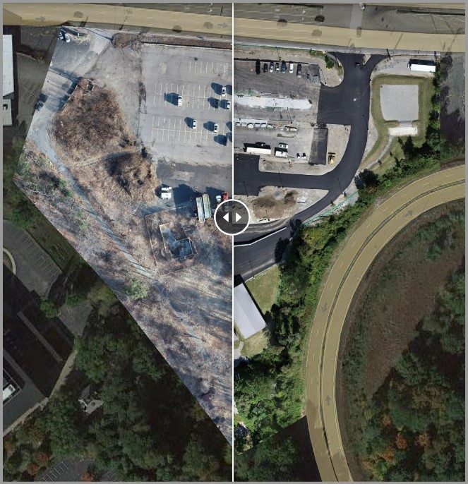
Project Tracking: Using a standard “slide” tool found in many GIS applications, MassDOT Highway engineers can efficiently compare progress between any two dates that the area was flown.


How Drones Collect and Use Data

MassDOT’s drones collect various types of data, like high-resolution images, 3D maps, thermal images, and LiDAR scans. This data helps with proactive maintenance and more accurate condition assessments, aiding in better planning and scheduling. Dr. Abood explained, “Thermal imaging helps us spot heat-related issues, while LiDAR scans give us precise measurements of the terrain and infrastructure.”
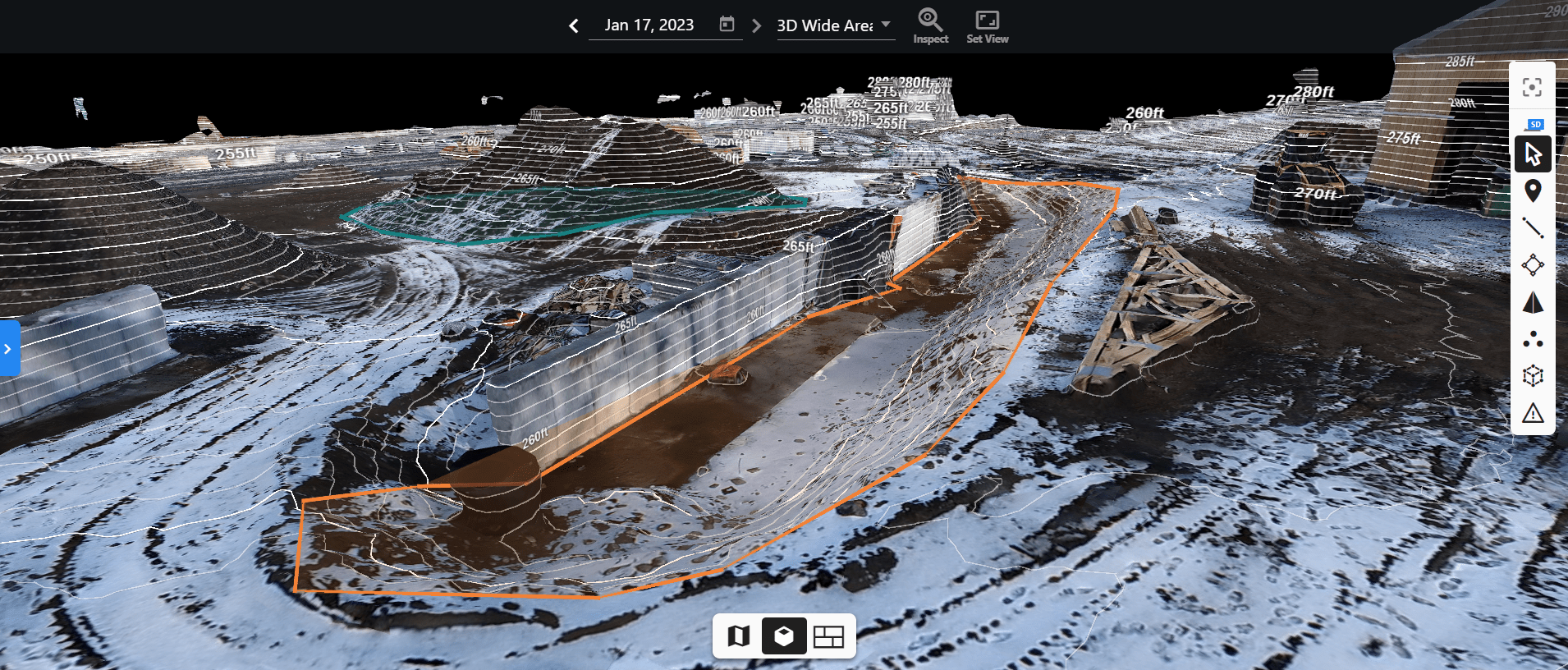
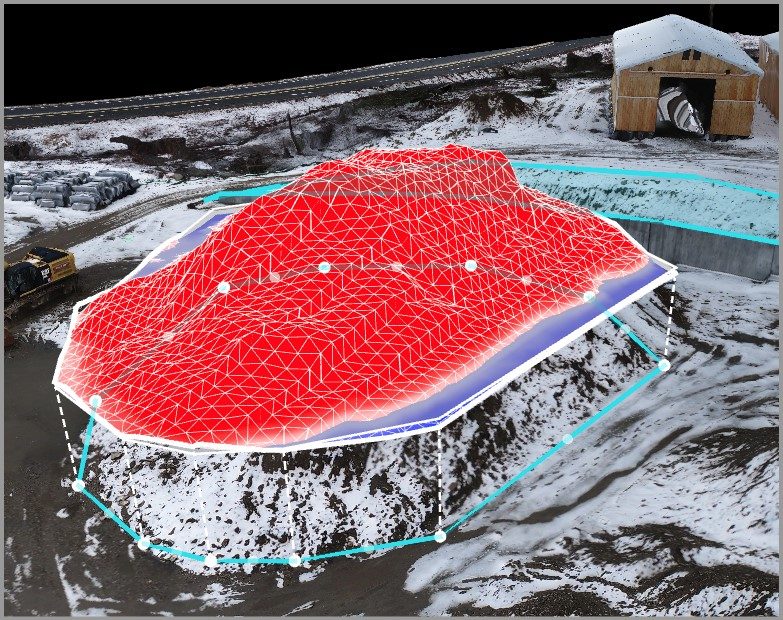
Framingham Stockpiles wContours: with the right workflows and processing, 3D models of the site can be created for a digital representation of the current site conditions.


Quantity Verification: project personnel can check or confirm material quantities with invoices while maintaining a digital record should any disputes need to be resolved down the road.

However, integrating this new data with existing systems isn’t always easy. Compatibility issues with older systems, data security, and managing the large volume of data are significant challenges.

Adapting to Different Environments

The drone-based system works in both rural and urban areas by adapting to the specific needs of each environment. In rural areas, drones need longer flight times and strong battery life to cover large distances. Dr. Abood gave examples like inspecting remote bridges and monitoring farmland for crop health.

In cities, drones need advanced navigation and obstacle avoidance systems to handle complex infrastructure. They also need to be mindful of noise and privacy concerns. Examples of urban projects include managing traffic and inspecting tall buildings. This adaptability ensures that drones can efficiently support infrastructure maintenance in diverse settings.

Aligning with Broader Goals

This project fits well with the goals of the Healey-Driscoll Administration, which focuses on equity, mobility, competitiveness, workforce development, and climate resilience. By ensuring consistent infrastructure quality across urban and rural areas, it promotes equitable access to safe transportation. The project also boosts Massachusetts’ competitiveness in infrastructure innovation and creates new job opportunities in drone operation and data analysis.

Dr. Abood highlighted the environmental benefits, stating, “Drones help us with proactive maintenance and adapting to climate impacts, strengthening climate resilience.” This initiative supports a more equitable, mobile, competitive, skilled, and resilient Massachusetts.
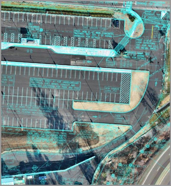
Documentation: having the ability to place CAD plans over the orthomosaic imagery enables for accurate progress tracking.

Long-Term Impacts and Future Prospects

If successful, this drone-based system could have a significant long-term impact on MassDOT and other transportation agencies across the country. The benefits include better infrastructure monitoring, improved data collection and analysis, and increased safety.

Regular and accurate inspections, cost savings from fewer manual inspections, and comprehensive data for better decision-making are key advantages. Using AI and machine learning with drone data can predict infrastructure issues before they become critical. Drones also reduce the risk to human inspectors and offer real-time monitoring during construction projects.

Dr. Abood noted that this project could influence future transportation management and policy decisions. “Successful implementation will likely lead to new regulatory frameworks, increased funding, and strategic planning based on data-driven decisions,” he said. This project could also foster public-private partnerships, create new skills within transportation agencies, and enhance transparency and public engagement.

MassDOT Aeronautics and MassDOT Highway are pioneering the use of drones and data analytics to revolutionize highway inspections and maintenance. With the $1 million AID grant, they aim to enhance the safety, efficiency, and effectiveness of the state’s transportation system, setting a new standard for public transportation management.

Read more:

  • MassDOT Showcases Innovation at Drone Safety Day
  • MassDOT Aeronautics to Conduct Cybersecurity Webinar for Drone Pilots: Monday, April 29
  • Drones on Cape Cod: Skyports and MassDOT Partner to Connect Remote Communities

Miriam McNabb

Miriam McNabb is the Editor-in-Chief of DRONELIFE and CEO of JobForDrones, a professional drone services marketplace, and a fascinated observer of the emerging drone industry and the regulatory environment for drones. Miriam has penned over 3,000 articles focused on the commercial drone space and is an international speaker and recognized figure in the industry.  Miriam has a degree from the University of Chicago and over 20 years of experience in high tech sales and marketing for new technologies.
For drone industry consulting or writing, Email Miriam.

TWITTER:@spaldingbarker

Subscribe to DroneLife here.

Filed Under: Applications, DL Exclusive, Drone News, Drone News Feeds, Drones in the News, Featured, News Tagged With: drone data analytics, drone highway inspections, drone-based infrastructure management, Federal Highway Administration AID, highway maintenance drones, highway safety technology, infrastructure inspection drones, MassDOT Aeronautics, MassDOT drone project, UAS technology in transportation

Reader Interactions

Leave a Reply Cancel reply

Your email address will not be published. Required fields are marked *

Primary Sidebar

LATEST

Cat-Inspired Claws Help Ice Dart Drone Land on Steep Ice

Université de Sherbrooke researchers demonstrate a new approach to landing multirotors on steep, irregular ice surfaces Cats may seem an…

Continue Reading Cat-Inspired Claws Help Ice Dart Drone Land on Steep Ice

Motorola Solutions Completes $1.5 Billion Acquisition of D-Fend Solutions

Counter-drone technology joins Motorola Solutions’ public safety portfolio as demand for airspace protection grows Motorola Solutions has completed its $1.5…

Continue Reading Motorola Solutions Completes $1.5 Billion Acquisition of D-Fend Solutions

Ondas Opens UAS Training and Operations Hub at Ohio’s NAAMCE

New Springfield facility will support long-endurance UAS training, testing and flight operations as Ondas expands its U.S. defense business Ondas…

Continue Reading Ondas Opens UAS Training and Operations Hub at Ohio’s NAAMCE

The White House Wants Drone Dominance. How Much of the Supply Chain Must Be American?

Recent executive orders, FCC action and a White House industry meeting point to growing scrutiny of what goes into U.S.-made…

Continue Reading The White House Wants Drone Dominance. How Much of the Supply Chain Must Be American?

FCC Proposal Could Bring Drone Software and Supply Chains Under Greater Scrutiny

Active FCC rulemaking considers hardware and software disclosures that could affect agricultural and commercial drone manufacturers A new FCC rulemaking…

Continue Reading FCC Proposal Could Bring Drone Software and Supply Chains Under Greater Scrutiny

United Utilities Uses Thermal Drones to Find Hidden Moorland Fire Hotspots

Thermal imaging drones help crews locate underground heat pockets that could reignite after major fires in northwest England. United Utilities…

Continue Reading United Utilities Uses Thermal Drones to Find Hidden Moorland Fire Hotspots

Inside the Counter-UAS Response to Drone Flights Over Spokane Wildfires

FBI and local officials describe how a multi-agency task force detected dozens of unauthorized drones, located pilots and worked to…

Continue Reading Inside the Counter-UAS Response to Drone Flights Over Spokane Wildfires

Saildrone Announces European Expansion With Copenhagen HQ and Three Build Contracts

The maritime autonomy company adds three European build partners and opens Northern Europe operations at the historic Quintus Bastion in…

Continue Reading Saildrone Announces European Expansion With Copenhagen HQ and Three Build Contracts

HOVERAir Launches VERSA 2-in-1 Gimbal and Camera Drone

The 2-in-1 device from ZeroZero Robotics records 4K 60fps video and converts from a pocket gimbal camera into a self-flying…

Continue Reading HOVERAir Launches VERSA 2-in-1 Gimbal and Camera Drone

uAvionix FlightLine Surveillance Data Feeds Airwise Nexus at Skyway Range in Tulsa

The partnership feeds low-altitude cooperative aircraft data from uAvionix’s FlightStation network into the Airwise Nexus platform for Skyway Range BVLOS…

Continue Reading uAvionix FlightLine Surveillance Data Feeds Airwise Nexus at Skyway Range in Tulsa

Secondary Sidebar

Footer

SPONSORED

What Is the Best Commercial Cleaning Drone in 2026? Specs, Prices, and a Head-to-Head Comparison

Inspired Flight Gremsy IF800 VIO F1 drones geo week

What Will It Take to Strengthen U.S. Drone Manufacturing? A Conversation with Inspired Flight’s CEO

Global Mapper Mobile data collection

Collection Ground Control Points with Global Mapper Mobile

Military Drone Mapping Solutions

How SimActive’s Correlator3D™ is Revolutionizing Military Mapping: An Exclusive Interview with CEO Philippe Simard

Photogrammetry Accuracy Standards

SimActive Photogrammetry Software: Enabling Users to Meet Accuracy Standards for Over 20 Years

NACT Engineering Parrot ANAFI tether indoor shot

Smart Tether for Parrot ANAFI USA from NACT Engineering

About Us | Contact Us | Advertise With Us | Write for Us | Privacy Policy | Terms of Service

The Trusted Source for the Business of Drones.

This website uses cookies and third party services. By clicking OK, you are agreeing to our privacy policy. ACCEPT

Manage consent

Privacy Overview

This website uses cookies to improve your experience while you navigate through the website. Out of these, the cookies that are categorized as necessary are stored on your browser as they are essential for the working of basic functionalities of the website. We also use third-party cookies that help us analyze and understand how you use this website. These cookies will be stored in your browser only with your consent. You also have the option to opt-out of these cookies. But opting out of some of these cookies may affect your browsing experience.
Necessary
Always Enabled
Necessary cookies are absolutely essential for the website to function properly. These cookies ensure basic functionalities and security features of the website, anonymously.
CookieDurationDescription
cookielawinfo-checkbox-analytics11 monthsThis cookie is set by GDPR Cookie Consent plugin. The cookie is used to store the user consent for the cookies in the category "Analytics".
cookielawinfo-checkbox-functional11 monthsThe cookie is set by GDPR cookie consent to record the user consent for the cookies in the category "Functional".
cookielawinfo-checkbox-necessary11 monthsThis cookie is set by GDPR Cookie Consent plugin. The cookies is used to store the user consent for the cookies in the category "Necessary".
cookielawinfo-checkbox-others11 monthsThis cookie is set by GDPR Cookie Consent plugin. The cookie is used to store the user consent for the cookies in the category "Other.
cookielawinfo-checkbox-performance11 monthsThis cookie is set by GDPR Cookie Consent plugin. The cookie is used to store the user consent for the cookies in the category "Performance".
viewed_cookie_policy11 monthsThe cookie is set by the GDPR Cookie Consent plugin and is used to store whether or not user has consented to the use of cookies. It does not store any personal data.
Functional
Functional cookies help to perform certain functionalities like sharing the content of the website on social media platforms, collect feedbacks, and other third-party features.
Performance
Performance cookies are used to understand and analyze the key performance indexes of the website which helps in delivering a better user experience for the visitors.
Analytics
Analytical cookies are used to understand how visitors interact with the website. These cookies help provide information on metrics the number of visitors, bounce rate, traffic source, etc.
Advertisement
Advertisement cookies are used to provide visitors with relevant ads and marketing campaigns. These cookies track visitors across websites and collect information to provide customized ads.
Others
Other uncategorized cookies are those that are being analyzed and have not been classified into a category as yet.
SAVE & ACCEPT




