• Skip to main content
  • Skip to secondary menu
  • Skip to primary sidebar
  • Skip to secondary sidebar
  • Skip to footer
  • DroneRacingLife
  • DroneFlyers
  • Newsletter
DroneLife

DRONELIFE

Stay up to date on all the latest Drone News

  • News
  • Products
  • Industries
    • Agriculture
    • Construction
    • Delivery
    • Dual Use
    • Inspection
    • Public Safety
    • Surveying
  • Enthusiasts
  • Regulations
  • Business
  • Video
  • Podcasts

New Oceanographic Survey Drone Can Take Off, Land, and Sail on the Water

July 22, 2024 by Miriam McNabb Leave a Comment

This article published in collaboration with JUIDA, the Japan UAS Industrial Development Association.

Penta Ocean Construction (President, Takuzo Shimizu) and Prodrone Co., Ltd. (President, Shunsuke Toya) have jointly developed the “Penta-Ocean Vanguard-DroneAqua” (POV-DA), an innovative oceanographic survey drone capable of taking off, landing, and sailing on the sea.

Oceanographic Survey Drone

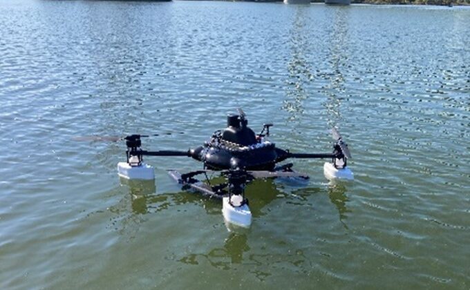
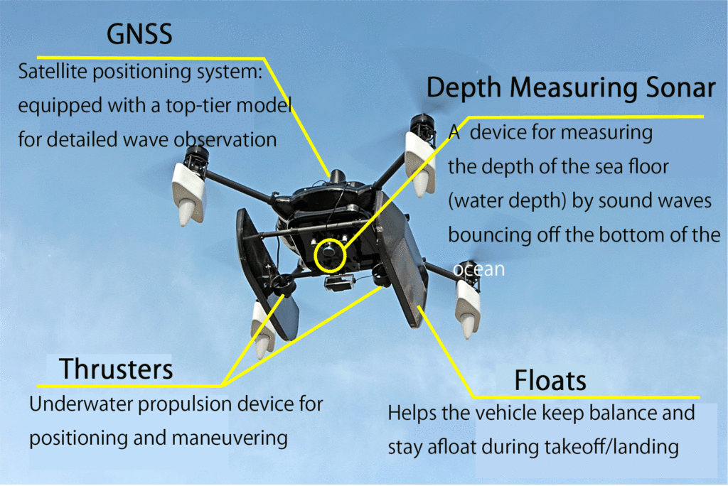
The POV-DA is designed for seamless water operations, equipped with a high-precision GNSS satellite system, thrusters, and a depth-measuring sonar. According to a Penta Ocean press release, the drone can transmit and display real-time data on its current location (X, Y, Z coordinates) and water depth to operators on land through a remote control console. The drone can navigate to specific monitoring points using its thrusters, maintaining position despite waves and swells. These capabilities enable efficient and automated bathymetric surveys and wave observations.

Oceanographic Survey Drone

Bathymetric Surveys

In construction projects involving breakwaters, quay walls, and similar structures, depth sounding has traditionally been performed using dedicated boats or lead sounding methods. With the introduction of POV-DA, the time required for depth surveys is significantly reduced. Real-time data transmission allows operators to monitor underwater construction progress and assess the need for additional soil dumping. The team confirmed that the POV-DA’s depth surveying accuracy is within +/-10cm of traditional methods, making it suitable for practical construction management.

Wave Observation

Marine construction management and safety often rely on weather and marine forecast data, as well as wave height measurements near the project site. Visual checks from the coastline are also performed to assess project feasibility. The POV-DA provides real-time wave height and period data derived from GNSS readings, allowing construction managers to assess site conditions more quickly and accurately. The drone’s measurements have been shown to vary by +/-10% or less compared to conventional wave meters, demonstrating its reliability for construction applications.

In addition to improving construction management efficiency and feasibility assessments, the POV-DA can take aerial shots for emergency support during disasters, providing real-time updates on land and underwater damages.

Future enhancements to the POV-DA may include additional equipment such as multi-parameter water quality meters and water sampling devices, broadening its applications to coastal environment preservation and comprehensive marine observations in construction projects.

Read more:

  • Japan’s Drone Industry Takes Flight: JUIDA’s New Model-Specific Pilot Licensure Program
  • Wingcopter and ITOCHU Advance Drone Delivery in Japan with New Certification Process
  • Japanese Drone Industry Rallies for Earthquake Recovery Efforts
Miriam McNabb

Miriam McNabb is the Editor-in-Chief of DRONELIFE and CEO of JobForDrones, a professional drone services marketplace, and a fascinated observer of the emerging drone industry and the regulatory environment for drones. Miriam has penned over 3,000 articles focused on the commercial drone space and is an international speaker and recognized figure in the industry.  Miriam has a degree from the University of Chicago and over 20 years of experience in high tech sales and marketing for new technologies.
For drone industry consulting or writing, Email Miriam.

TWITTER:@spaldingbarker

Subscribe to DroneLife here.

Filed Under: Applications, Drone News, Drone News Feeds, News Tagged With: bathymetric surveys, construction technology, GNSS satellite system, marine construction, marine safety, oceanographic survey drone, Prodrone, real-time data, underwater monitoring, wave observation

Reader Interactions

Leave a Reply Cancel reply

Your email address will not be published. Required fields are marked *

Primary Sidebar

LATEST

Africa Pavilion to Debut at XPONENTIAL Europe 2026

African Drone Forum initiative highlights growing role of African innovators in global autonomy ecosystem The African Drone Forum (ADF) has…

Continue Reading Africa Pavilion to Debut at XPONENTIAL Europe 2026

Everdrone Raises SEK 36 Million to Expand Drone-Based Emergency Healthcare Services

Funding supports commercialization and expansion of drone-delivered medical response systems across Europe Everdrone has raised SEK 36 million in a…

Continue Reading Everdrone Raises SEK 36 Million to Expand Drone-Based Emergency Healthcare Services

Palantir, Ondas, and World View Partner on Multi-Domain ISR Integration

Palantir Technologies, Ondas Inc., and World View Enterprises have announced a strategic partnership to develop an AI-enabled operational architecture for multi-domain…

Continue Reading Palantir, Ondas, and World View Partner on Multi-Domain ISR Integration

Alpine Eagle Scales Counter-Drone Production as European Demand Grows

Sentinel system expansion reflects rising need for deployable, cost-effective air defense solutions Alpine Eagle, a European counter-drone technology company, is…

Continue Reading Alpine Eagle Scales Counter-Drone Production as European Demand Grows

Fortem DroneHunter and TrueView Radar Join Lockheed Martin Sanctum

Fortem Technologies has announced a new contract with Lockheed Martin to deploy autonomous counter-drone systems for critical infrastructure protection. The…

Continue Reading Fortem DroneHunter and TrueView Radar Join Lockheed Martin Sanctum

DHS Taps Fortem for Kinetic Counter-UAS Systems at World Cup Venues

By Dronelife Features Editor Jim Magill (Editor’s note: This story is part of a series of reports on efforts to…

Continue Reading DHS Taps Fortem for Kinetic Counter-UAS Systems at World Cup Venues

DroneShield Integrates Robin Radar for Layered Drone Airspace Protection

DroneShield has announced a new partnership with Robin Radar Systems to expand its counter-UAS sensor ecosystem. The agreement integrates Robin’s…

Continue Reading DroneShield Integrates Robin Radar for Layered Drone Airspace Protection

Warren County Community College Launches Counter-Drone Security Training Program

New curriculum will train students and professionals to identify and respond to drone threats Warren County Community College (WCCC) in…

Continue Reading Warren County Community College Launches Counter-Drone Security Training Program

Drone Warfare Expertise Is Becoming a Global Export Industry

A review of today’s international news reveals a growing market for drone warfare knowledge and counter-UAS technology A review of…

Continue Reading Drone Warfare Expertise Is Becoming a Global Export Industry

FAA’s DiSCVR System Helps Law Enforcement Identify Drones in Flight

New FAA data tool connects Remote ID broadcasts with registration and airspace authorization records As drone use continues to grow…

Continue Reading FAA’s DiSCVR System Helps Law Enforcement Identify Drones in Flight

Secondary Sidebar

Footer

SPONSORED

Inspired Flight Gremsy IF800 VIO F1 drones geo week

What Will It Take to Strengthen U.S. Drone Manufacturing? A Conversation with Inspired Flight’s CEO

Global Mapper Mobile data collection

Collection Ground Control Points with Global Mapper Mobile

Military Drone Mapping Solutions

How SimActive’s Correlator3D™ is Revolutionizing Military Mapping: An Exclusive Interview with CEO Philippe Simard

Photogrammetry Accuracy Standards

SimActive Photogrammetry Software: Enabling Users to Meet Accuracy Standards for Over 20 Years

NACT Engineering Parrot ANAFI tether indoor shot

Smart Tether for Parrot ANAFI USA from NACT Engineering

Blue Marble, features global mapper, features Blue Marble

Check Out These New Features in Global Mapper v25 from Blue Marble

About Us | Contact Us | Advertise With Us | Write for Us | Privacy Policy | Terms of Service

The Trusted Source for the Business of Drones.

This website uses cookies and third party services. By clicking OK, you are agreeing to our privacy policy. ACCEPT

Manage consent

Privacy Overview

This website uses cookies to improve your experience while you navigate through the website. Out of these, the cookies that are categorized as necessary are stored on your browser as they are essential for the working of basic functionalities of the website. We also use third-party cookies that help us analyze and understand how you use this website. These cookies will be stored in your browser only with your consent. You also have the option to opt-out of these cookies. But opting out of some of these cookies may affect your browsing experience.
Necessary
Always Enabled
Necessary cookies are absolutely essential for the website to function properly. These cookies ensure basic functionalities and security features of the website, anonymously.
CookieDurationDescription
cookielawinfo-checkbox-analytics11 monthsThis cookie is set by GDPR Cookie Consent plugin. The cookie is used to store the user consent for the cookies in the category "Analytics".
cookielawinfo-checkbox-functional11 monthsThe cookie is set by GDPR cookie consent to record the user consent for the cookies in the category "Functional".
cookielawinfo-checkbox-necessary11 monthsThis cookie is set by GDPR Cookie Consent plugin. The cookies is used to store the user consent for the cookies in the category "Necessary".
cookielawinfo-checkbox-others11 monthsThis cookie is set by GDPR Cookie Consent plugin. The cookie is used to store the user consent for the cookies in the category "Other.
cookielawinfo-checkbox-performance11 monthsThis cookie is set by GDPR Cookie Consent plugin. The cookie is used to store the user consent for the cookies in the category "Performance".
viewed_cookie_policy11 monthsThe cookie is set by the GDPR Cookie Consent plugin and is used to store whether or not user has consented to the use of cookies. It does not store any personal data.
Functional
Functional cookies help to perform certain functionalities like sharing the content of the website on social media platforms, collect feedbacks, and other third-party features.
Performance
Performance cookies are used to understand and analyze the key performance indexes of the website which helps in delivering a better user experience for the visitors.
Analytics
Analytical cookies are used to understand how visitors interact with the website. These cookies help provide information on metrics the number of visitors, bounce rate, traffic source, etc.
Advertisement
Advertisement cookies are used to provide visitors with relevant ads and marketing campaigns. These cookies track visitors across websites and collect information to provide customized ads.
Others
Other uncategorized cookies are those that are being analyzed and have not been classified into a category as yet.
SAVE & ACCEPT