
Read or listen to all of the headlines in one place: excerpts from the DRONELIFE drone news of the week ending March 1, 2024. Click on the titles below for the full story.
Continue reading below, or listen:
News and Commentary. In San Francisco, Prop E will be on the ballot on March 5. Among other provisions designed to help public safety agencies deal with rising crime rates in the city, Prop E would ease the way for police drone use. The discussion in San Francisco’s media, however, has highlighted the drone industry’s imperative to educate community leaders and lawmakers about what drones are good at – the de-escalation and better outcomes that most communities hope for.
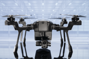 Teledyne FLIR Partners with PoliceGrantsHelp to Boost Public Safety Solutions
Drone and sensor developer Teledyne FLIR has recently announced a partnership with PoliceGrantsHelp.com, who help eligible agencies gain access to grants, increasing the affordability of their public safety-focused solutions. Designed to help “bridge the gap” between operational needs and budget realities, grants are vital to maximizing the capabilities of departments of all sizes. Teledyne FLIR is now offering their SIRAS professional drone alongside a comprehensive set of grant consulting services designed to defray costs for eligible customers.
 Texas Police Secure Drone Data, Aim to Preserve Fleets Despite Ban Attempts
As both state and federal officials try to limit, if not outright ban, the use of Chinese-made drones by public service agencies, police departments and sheriff’s offices in Texas have taken steps to ensure that those UAVs in their fleets do not present the security threat that ban advocates fear. In the last several years, many, if not most municipal police departments and county sheriff’s offices in the Lone Star State have established UAV programs. Among those police agencies with unmanned aerial system (UAS) programs, aerial vehicles produced by Da-Jiang Innovations (DJI) typically comprise the bulk of their fleets.
 Skyebrowse Introduces Affordable Photogrammetry Software Tier
Texas-based mapping software developer Skyebrowse recently announced a new “Lite” tier for their flagship affordable photogrammetry software, making access to high-quality mapping more accessible for organizations than ever. While missing certain professional tools and access to long-term CJIS-compliant cloud storage, Skyebrowse Lite comes in at $49 a month and features a higher level of accuracy, higher priority processing, and a full year of cloud storage than their pay-per-model “freemium” tier.
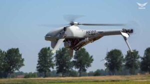 High Eye Wins Netherlands Ministry of Defence Tender with Airboxer VTOL UAV
In a significant development for both the defense industry and unmanned aerial vehicle (UAV) technology, High Eye has been announced as the winner of an international tender issued by the Netherlands Ministry of Defence. This achievement marks a noteworthy milestone in High Eye’s journey of innovation and growth, showcasing their commitment to advancing UAV capabilities on a global scale. The tender win highlights the exceptional quality and capability of High Eye’s flagship product, the Airboxer. This VTOL (Vertical Take-Off and Landing) UAV is set to be integrated comprehensively into the operations of the Netherlands Ministry of Defence over a program spanning more than two years. The integration will cover both European and international operations, emphasizing the versatile applicability of the Airboxer system.
 The LiDAR Pros: Comprehensive LiDAR Drone Services from the Experts of Sundance Media Group
The integration of LiDAR technology into commercial drone operations continues to revolutionize industries such as architecture, surveying, construction, and public safety. The precision and efficiency offered by LiDAR have prompted significant advancements in data collection, enabling companies to streamline processes and enhance project outcomes. The LiDAR Pros, LLC, headquartered in Las Vegas, NV, has recently announced an expansion of their services and drone reselling operations in the Southwest region. Boasting a team with over 80 years of collective experience in aviation and UAS data collection, The LiDAR Pros are positioned to cater to a wide range of projects spanning Nevada, Utah, Idaho, Southwest Colorado, western Arizona, and California.
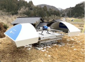
In the wake of the devastating Noto Peninsula Earthquake that struck on January 1, 2024, Japan’s response has been characterized by innovative drone technology and collaborative relief efforts spearheaded by various companies in partnership with the Japan UAS Industrial Development Association (JUIDA). JUIDA, in coordination with the local government and the Japan Ground Self-Defense Force (JGSDF) 10th Division, swiftly dispatched an integrated crisis general manager to the affected area. Together with partner companies, they initiated a wide array of activities, including searching for victims, delivering medicine, conducting aerial photography of the affected regions, and monitoring sediment dams using drone ports over an extended period. According to JUIDA, this marks the first large-scale, systematic operation of unmanned aerial vehicles during a disaster in Japan.

Miriam McNabb is the Editor-in-Chief of DRONELIFE and CEO of JobForDrones, a professional drone services marketplace, and a fascinated observer of the emerging drone industry and the regulatory environment for drones. Miriam has penned over 3,000 articles focused on the commercial drone space and is an international speaker and recognized figure in the industry. Miriam has a degree from the University of Chicago and over 20 years of experience in high tech sales and marketing for new technologies.
For drone industry consulting or writing, Email Miriam.
TWITTER:@spaldingbarker
Subscribe to DroneLife here.




[…] Supply hyperlink asubhan wordpress autoblog amazon autoblog affiliate autoblog wordpress web site web site growth […]