• Skip to main content
  • Skip to secondary menu
  • Skip to primary sidebar
  • Skip to secondary sidebar
  • Skip to footer
  • DroneRacingLife
  • DroneFlyers
  • Newsletter
DroneLife

DRONELIFE

Stay up to date on all the latest Drone News

  • News
  • Products
  • Industries
    • Agriculture
    • Construction
    • Delivery
    • Dual Use
    • Inspection
    • Public Safety
    • Surveying
  • Enthusiasts
  • Regulations
  • Business
  • Video
  • Podcasts

Pix4D Launches Next Gen Suite of Tools [Video]

April 1, 2020 by Miriam McNabb 10 Comments

Pix 4D is expanding their enterprise toolset beyond their mapping roots – although the Pix4DMapper platform continues to evolve and improve, staying out ahead of the curve in accuracy and processing time.  Now, the company announces the addition of a totally new generation of tools to the Pix4D suite:  Pix4Dsurvey, Pix4Dmatic, Pix4Dinspect, and Pix4Dscan.  See the video below for a teaser – and then read on for the details on how Pix4D is creating maximum value for enterprise drone teams.

The following is a Pix4D press release.

Lausanne, Switzerland, March 31st, 2020

 Photogrammetry leader Pix4D is announcing today the commercial release of next-generation software addressing the modern-day professional challenges. Developed in close collaboration with customers and partners, Pix4Dsurvey, Pix4Dmatic, Pix4Dinspect, and Pix4Dscan will contribute to revolutionizing the way professional customers operate and deliver their services.

Breaking ground with Pix4Dsurvey & Pix4Dmatic

Digital photogrammetry is an essential part of every modern surveyor’s toolkit and has contributed to launching hundreds of new drone mapping businesses around the world. Pix4Dsurvey and Pix4Dmatic represent the next step in photogrammetry, addressing major challenges in the geospatial industry.

Pix4Dsurvey is bridging the gap between digital photogrammetry and CAD by transforming point data into CAD-ready formats. It allows the vectorization of any element, thanks to the rayCloud environment. Dramatically reducing overall surveying time, and expanding possibilities for surveying and mapping professionals, Pix4Dsurvey is now available for trial and purchase.

Pix4Dmatic, a new photogrammetry software product, will enable accurate drone mapping on a new scale. Built for the latest generation of drones, it is optimized for processing thousands of images while maintaining survey-grade accuracy, halving the time taken to deliver your large project from images to point cloud. Pix4Dmatic beta program is now open for applications.

In addition, Pix4Dmapper version 4.5, a new update of the leading desktop photogrammetry software, is now available for download. With speed-up in the image calibration and point cloud generation by an average of 20% in both steps, it now enables users to process projects faster than ever.

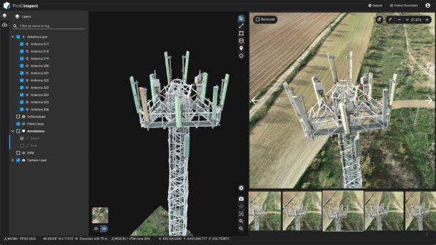
Automating industrial inspection with Pix4Dscan & Pix4Dinspect

Manual inspection of industrial assets and infrastructure is time-consuming, expensive and at times dangerous. Current technology has reduced the danger but the process remains long and costly. Pix4Dscan and Pix4Dinspect will change that.

Pix4Dscan is a drone flight app designed to deal with complex structures. Pix4Dinspect cloud-based software is an analytics platform able to manage and inspect digital assets modelled with Pix4D’s best-in-market photogrammetry. Together they deliver an end-to-end solution for industrial inspections and asset management.

New and improved Pix4D Training platform and offering

New software needs first-class training material. This is why the new Pix4D Training platform is now easier than ever to access. All resources —from quick tip videos to official certifications — can be found at training.pix4d.com.

Christoph Strecha, Pix4D’s Founder and CEO, comments: “I am confident this set of mobile, cloud and desktop software are a major evolution for drone mapping applications, allowing projects to get progressively larger, and making data more actionable than ever. These products will revolutionize the way professionals work, improving efficiency and expanding possibilities.”

About Pix4D

 Pix4D (pix4d.com) develops cutting-edge software that converts images taken by hand, by drone or by plane into accurate and georeferenced survey-grade 2D mosaics, 3D models and point clouds. The dynamic and rapidly expanding company, founded in 2011, is based in Switzerland, with offices in San Francisco, Denver, Shanghai, Berlin, Madrid and Tokyo.


Miriam McNabb

Miriam McNabb is the Editor-in-Chief of DRONELIFE and CEO of JobForDrones, a professional drone services marketplace, and a fascinated observer of the emerging drone industry and the regulatory environment for drones. Miriam has penned over 3,000 articles focused on the commercial drone space and is an international speaker and recognized figure in the industry.  Miriam has a degree from the University of Chicago and over 20 years of experience in high tech sales and marketing for new technologies.
For drone industry consulting or writing, Email Miriam.

TWITTER:@spaldingbarker

Subscribe to DroneLife here.

Filed Under: Drone News Feeds, News Tagged With: aerial imagery, commercial drone program, Commercial Drones, drone mapping platform, Drones for Construction, drones for inspection, drones for surveying, Pix4D

Reader Interactions

Trackbacks

  1. Pix4D Donates Pix4Dreact to Non-Profits - Best Drones Online says:
    August 19, 2021 at 2:14 pm

    […] is on the floor at AUVSI Xponential in Atlanta this week, demonstrating their suite of mapping products.  One of these is Pix4Dreact, the fast mapping product for emergency response […]

    Reply
  2. Pix4D Donates Pix4Dreact to Non-Profits – Gadsofgods says:
    August 19, 2021 at 1:56 pm

    […] is on the floor at AUVSI Xponential in Atlanta this week, demonstrating their suite of mapping products.  One of these is Pix4Dreact, the fast mapping product for emergency response […]

    Reply
  3. Pix4D Donates Pix4Dreact to Non-Profits - Secopter says:
    August 19, 2021 at 9:26 am

    […] is on the floor at AUVSI Xponential in Atlanta this week, demonstrating their suite of mapping products.  One of these is Pix4Dreact, the fast mapping product for emergency response […]

    Reply
  4. Pix4D Donates Pix4D React – to Any Non-Profit that Needs It - Summer Of Drones News says:
    August 19, 2021 at 9:22 am

    […] is on the ground at AUVSI Xponential in Atlanta this week, demonstrating their suite of mapping products.  One of those is Pix4Dreact, the quick mapping product for emergency response […]

    Reply
  5. Pix4D Donates Pix4D React – to Any Non-Profit that Needs It - The Drone Page says:
    August 19, 2021 at 9:19 am

    […] is on the floor at AUVSI Xponential in Atlanta this week, demonstrating their suite of mapping products.  One of these is Pix4Dreact, the fast mapping product for emergency response […]

    Reply
  6. Autel and Pix4D Partner for the Ultimate Public Safety Drone Solution | Gadgets says:
    August 27, 2020 at 5:37 pm

    […] Group, the Autel Evo II flew over a mock nighttime crime scene for evidence documentation: and Pix4Dreact, Pix4D’s real-time mapping solution for law enforcement, sent the scene to a large screen on a […]

    Reply
  7. Pix4D Launches Subsequent Gen Suite of Instruments [Video] - Drone Stuff Pro says:
    April 1, 2020 at 9:08 pm

    […] Supply hyperlink […]

    Reply
  8. Pix4D Launches Next Gen Suite of Tools [Video] | Drone Magazine says:
    April 1, 2020 at 4:13 pm

    […] Source […]

    Reply
  9. Pix4D Launches Next Gen Suite of Tools [Video] | Gadgets says:
    April 1, 2020 at 3:56 pm

    […] Source link […]

    Reply
  10. Pix4D Launches Next Gen Suite of Tools [Video] ⋆ says:
    April 1, 2020 at 1:54 pm

    […] The complete article is here […]

    Reply

Leave a Reply Cancel reply

Your email address will not be published. Required fields are marked *

Primary Sidebar

LATEST

Teledyne FLIR OEM Upgrades Prism SKR Software for Autonomous Target Recognition

New release combines mission execution and intelligent supervision in a single autonomy platform Teledyne FLIR OEM has announced an upgrade…

Continue Reading Teledyne FLIR OEM Upgrades Prism SKR Software for Autonomous Target Recognition

Drone Operations Software Company AirHub Closes €4.4M Series A

AirHub, a European drone operations software company based in The Hague, has closed a €4.4 million Series A funding round.…

Continue Reading Drone Operations Software Company AirHub Closes €4.4M Series A

Arrive AI Patents Shared Drone Delivery Endpoint With Tenth U.S. Patent

Arrive AI (NASDAQ: ARAI) has secured its tenth U.S. patent, strengthening its intellectual property portfolio for autonomous drone delivery infrastructure.…

Continue Reading Arrive AI Patents Shared Drone Delivery Endpoint With Tenth U.S. Patent

Korean eVTOL Developer Airbility Partners on UAV Public Safety in Thailand

South Korean eVTOL developer Airbility has signed a four-party Memorandum of Understanding to deploy UAV systems for public safety and…

Continue Reading Korean eVTOL Developer Airbility Partners on UAV Public Safety in Thailand

Is U.S. Manufacturing the Answer? SKYROVER Signals a New Strategy as FCC Pressure Mounts

A Hong Kong-based drone company outlines a five-year U.S. roadmap, raising questions about compliance, supply chains, and market access A…

Continue Reading Is U.S. Manufacturing the Answer? SKYROVER Signals a New Strategy as FCC Pressure Mounts

Blue Marble Geographics and Avenza Systems Combine to Create Unified Geospatial Platform

Merger connects office-based analysis with field operations for end-to-end spatial workflows Blue Marble Geographics and Avenza Systems, Inc. have announced…

Continue Reading Blue Marble Geographics and Avenza Systems Combine to Create Unified Geospatial Platform

Amazon Prime Air Adjusts Course After Richardson Setbacks

After rocky start in Texas city, Amazon Air service flying high By DRONELIFE Features Editor Jim Magill After only a…

Continue Reading Amazon Prime Air Adjusts Course After Richardson Setbacks

Airspace Security at 2026 JUNO Awards

RF-Cyber counter-drone system enables non-disruptive protection for large public event D-Fend Solutions announced that its EnforceAir counter-drone system was deployed…

Continue Reading Airspace Security at 2026 JUNO Awards

Will States Be Ready with Counter Drone Tech for the FIFA World Cup?

Funding snafu, other issues delay counter-UAS ramp-up in Maryland, elsewhere By DRONELIFE Features Editor Jim Magill (Editor’s note: This is…

Continue Reading Will States Be Ready with Counter Drone Tech for the FIFA World Cup?

Strait of Hormuz Tensions Highlight a Growing Role for Small Drone Surveillance

Maritime risk, insurance pressure, and degraded navigation signals point to new use cases for commercial UAV systems Ongoing tension in…

Continue Reading Strait of Hormuz Tensions Highlight a Growing Role for Small Drone Surveillance

Secondary Sidebar

Footer

SPONSORED

Inspired Flight Gremsy IF800 VIO F1 drones geo week

What Will It Take to Strengthen U.S. Drone Manufacturing? A Conversation with Inspired Flight’s CEO

Global Mapper Mobile data collection

Collection Ground Control Points with Global Mapper Mobile

Military Drone Mapping Solutions

How SimActive’s Correlator3D™ is Revolutionizing Military Mapping: An Exclusive Interview with CEO Philippe Simard

Photogrammetry Accuracy Standards

SimActive Photogrammetry Software: Enabling Users to Meet Accuracy Standards for Over 20 Years

NACT Engineering Parrot ANAFI tether indoor shot

Smart Tether for Parrot ANAFI USA from NACT Engineering

Blue Marble, features global mapper, features Blue Marble

Check Out These New Features in Global Mapper v25 from Blue Marble

About Us | Contact Us | Advertise With Us | Write for Us | Privacy Policy | Terms of Service

The Trusted Source for the Business of Drones.

This website uses cookies and third party services. By clicking OK, you are agreeing to our privacy policy. ACCEPT

Manage consent

Privacy Overview

This website uses cookies to improve your experience while you navigate through the website. Out of these, the cookies that are categorized as necessary are stored on your browser as they are essential for the working of basic functionalities of the website. We also use third-party cookies that help us analyze and understand how you use this website. These cookies will be stored in your browser only with your consent. You also have the option to opt-out of these cookies. But opting out of some of these cookies may affect your browsing experience.
Necessary
Always Enabled
Necessary cookies are absolutely essential for the website to function properly. These cookies ensure basic functionalities and security features of the website, anonymously.
CookieDurationDescription
cookielawinfo-checkbox-analytics11 monthsThis cookie is set by GDPR Cookie Consent plugin. The cookie is used to store the user consent for the cookies in the category "Analytics".
cookielawinfo-checkbox-functional11 monthsThe cookie is set by GDPR cookie consent to record the user consent for the cookies in the category "Functional".
cookielawinfo-checkbox-necessary11 monthsThis cookie is set by GDPR Cookie Consent plugin. The cookies is used to store the user consent for the cookies in the category "Necessary".
cookielawinfo-checkbox-others11 monthsThis cookie is set by GDPR Cookie Consent plugin. The cookie is used to store the user consent for the cookies in the category "Other.
cookielawinfo-checkbox-performance11 monthsThis cookie is set by GDPR Cookie Consent plugin. The cookie is used to store the user consent for the cookies in the category "Performance".
viewed_cookie_policy11 monthsThe cookie is set by the GDPR Cookie Consent plugin and is used to store whether or not user has consented to the use of cookies. It does not store any personal data.
Functional
Functional cookies help to perform certain functionalities like sharing the content of the website on social media platforms, collect feedbacks, and other third-party features.
Performance
Performance cookies are used to understand and analyze the key performance indexes of the website which helps in delivering a better user experience for the visitors.
Analytics
Analytical cookies are used to understand how visitors interact with the website. These cookies help provide information on metrics the number of visitors, bounce rate, traffic source, etc.
Advertisement
Advertisement cookies are used to provide visitors with relevant ads and marketing campaigns. These cookies track visitors across websites and collect information to provide customized ads.
Others
Other uncategorized cookies are those that are being analyzed and have not been classified into a category as yet.
SAVE & ACCEPT